Flinders Street, Adelaide

Last updated

Flinders Street

Flinders St.JPG
Flinders Street, looking east from King William Street
Flinders Street, Adelaide
Australia South Australia City of Adelaide location map.svg
Red pog.svg
West end
Red pog.svg
East end
Coordinates
General information
TypeStreet
Location Adelaide city centre
Length1.2 km (0.7 mi) [1]
Opened1837
Major junctions
West end King William Street
Adelaide
 
East end East Terrace
Adelaide
Location(s)
LGA(s) City of Adelaide

Flinders Street is a main street in the city centre of Adelaide, South Australia. It runs from the northern end of Victoria Square to East Terrace. It is one of the intermediate-width streets of the Adelaide grid, at 1+12 chains (99  ft ; 30  m ) wide. [2] [3] [4]

Contents

History

The street is named after the navigator and cartographer Captain Matthew Flinders. [5]

On 22 November 1878 the East Adelaide Model School, later Flinders Street Public School or Flinders Street Model School, [6] was opened in large bluestone buildings designed by E. J. Woods. A primary school occupied the premises until 1969, when the Flinders Street Adult Education Centre was established there. In 1978 it became the Flinders St School of Music, a campus of TAFE. [5]

Many churches were built on Flinders Street in the 1860s and 1870s, and several survive today. [5] [7]

In August 2022, the City of Adelaide renamed a laneway off Flinders Street, behind Adelaide Town Hall, Paul Kelly Lane. Previously named Pilgrim Lane after the adjacent church, the lane is now called Paul Kelly Lane. It is the fourth such renaming after musicians associated with the city, the others being Sia Furler, No Fixed Address, and Cold Chisel. [8]

Historic buildings

Churches

As of 2022 churches on Flinders Street include:

Other historic buildings

Junction list

Locationkm [1] miDestinationsNotes
Adelaide city centre 00.0 Victoria Square, King William Street Continues as Franklin Street
0.20.12 Gawler Place
0.550.34 Pulteney Street
0.750.47 Frome Street
1.10.68 Hutt Street Eastern side of the intersection is permanently closed to traffic
1.20.75 East Terrace
1.000 mi = 1.609 km; 1.000 km = 0.621 mi

See also

Australia road sign W5-29.svg   Australian Roadsportal

Footnotes

  1. The Hermannsburg Choir sang at this church on their 1967 tour. [11]

Related Research Articles

<span class="mw-page-title-main">Hermannsburg, Northern Territory</span> Town in the Northern Territory, Australia

Hermannsburg, also known as Ntaria, is an Aboriginal community in Ljirapinta Ward of the MacDonnell Shire in the Northern Territory of Australia, 125 kilometres (78 mi); west southwest of Alice Springs, on the Finke River, in the traditional lands of the Western Arrarnta people.

<span class="mw-page-title-main">Norwood, South Australia</span> Suburb of Adelaide, South Australia

Norwood is a suburb of Adelaide, about 4 km (2.5 mi) east of the Adelaide city centre. The suburb is in the City of Norwood Payneham & St Peters, whose predecessor was the oldest South Australian local government municipality.

<span class="mw-page-title-main">Gatton, Queensland</span> Town in Queensland, Australia

Gatton is a rural town and locality in the Lockyer Valley Region, Queensland, Australia. In the 2016 census, the locality of Gatton had a population of 7,101 people.

<span class="mw-page-title-main">ACDC Lane</span> Road in Melbourne, Victoria

AC/DC Lane is a laneway in the central business district of Melbourne, Victoria, Australia. A short and narrow street running off Flinders Lane, it runs roughly north–south in between Exhibition Street and Russell Street. The lane is named as a tribute to the famous Australian hard rock band AC/DC.

<span class="mw-page-title-main">Roadvale, Queensland</span> Town in Queensland, Australia

Roadvale is a rural locality in the Scenic Rim Region, Queensland, Australia. In the 2021 census, Roadvale had a population of 303 people.

<span class="mw-page-title-main">Laidley, Queensland</span> Town in Queensland, Australia

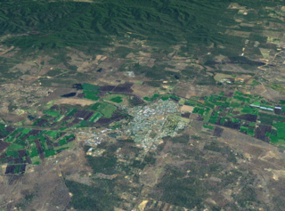
Laidley is a rural town and locality in the Lockyer Valley Region, Queensland, Australia. In the 2016 census, the locality of Laidley had a population of 3,808 people.

<span class="mw-page-title-main">Brisbane central business district</span> Suburb of Brisbane, Queensland, Australia

Brisbane City is the central suburb and central business district of Brisbane, the state capital of Queensland, Australia. It is colloquially referred to as the "Brisbane CBD" or "the city". It is located on a point on the northern bank of the Brisbane River, historically known as Meanjin, Mianjin or Meeanjin in the local Aboriginal Australian dialect. The triangular shaped area is bounded by the median of the Brisbane River to the east, south and west. The point, known at its tip as Gardens Point, slopes upward to the north-west where the city is bounded by parkland and the inner city suburb of Spring Hill to the north. The CBD is bounded to the north-east by the suburb of Fortitude Valley. To the west the CBD is bounded by Petrie Terrace, which in 2010 was reinstated as a suburb.

<span class="mw-page-title-main">Aratula</span> Town in Queensland, Australia

Aratula is a rural town and locality in the Scenic Rim Region, Queensland, Australia. In the 2016 census, the locality of Aratula had a population of 532 people.

Newmarket is a north-west suburb in the City of Brisbane, Queensland, Australia. In the 2016 census, Newmarket had a population of 4,979 people.

<span class="mw-page-title-main">Rosewood, Queensland</span> Town in Queensland, Australia

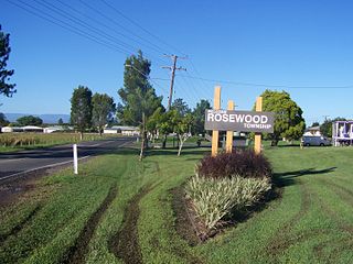
Rosewood is a rural town and locality in the City of Ipswich, Queensland, Australia. In the 2016 census, the locality of Rosewood had a population of 2,834 people.

Morphett Street is a main street in the west of the city centre of Adelaide, South Australia, parallel to King William Street and numbered from north to south. At its northern end it is part of the West End of Adelaide, a thriving cultural and entertainment precinct, with the Lion Arts Centre on the south-western corner of its junction with North Terrace.

<span class="mw-page-title-main">Townsville City, Queensland</span> Suburb of Townsville, Queensland, Australia

Townsville City is a coastal suburb at the centre of the City of Townsville, Queensland, Australia. In the 2016 census, the suburb of Townsville City had a population of 2,910 people.

Ntaria Choir, formerly known as Ntaria Ladies Choir, Hermannsburg Ladies Choir, Hermannsburg Choir], and various other names, is a choir of Australian Aboriginal people from Hermannsburg in Central Australia. The members of the choir are Arrernte people from the area and they sing a mixture of English, Arrente, and Pitjantjatjara.

<span class="mw-page-title-main">Hutt Street</span> Street in Adelaide, South Australia

Hutt Street is the easternmost of the five major north–south roads running through the City of Adelaide. It runs from Pirie Street to South Terrace, from where it continues south as Hutt Road. Flanked by leafy side streets with many late 19th-century dwellings, it is home to a wide range of restaurants, two pubs, shops, offices and professional and medical suites.

<span class="mw-page-title-main">Lanes and arcades of Melbourne</span>

The Melbourne central business district in Australia is home to numerous lanes and arcades. Often called "laneways", these narrow streets and pedestrian paths date mostly from the Victorian era, and are a popular cultural attraction for their cafes, bars and street art.

<span class="mw-page-title-main">Pilgrim Uniting Church</span> Church in South Australia, Australia

Pilgrim Uniting Church is a Uniting church located on Flinders Street, Adelaide in South Australia.

Sandleton is a locality and former town in South Australia. It is located on the plains on the eastern side of the Mount Lofty Ranges. The current boundaries for the locality were created in 2003 for the long-established name of the area.

Urraween is a suburb of Hervey Bay in the Fraser Coast Region, Queensland, Australia. At the 2021 census Urraween had a population of 7,951.

<span class="mw-page-title-main">Flinders Street Baptist Church</span> Church in Australia

Flinders Street Baptist Church is a heritage-listed Baptist church located at 71-75 Flinders Street, Adelaide, South Australia, Australia. The church is affiliated with the Australian Baptist Ministries.

<span class="mw-page-title-main">Lanes and alleyways of Sydney</span>

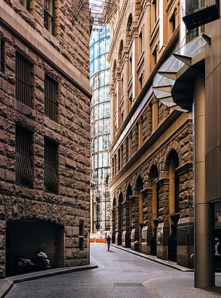
The lanes and alleyways of Sydney are a series of passageways found in Sydney central business district that have historically functioned by providing both off-street vehicular access to city buildings and secondary pedestrian routes through city blocks. They generally feature street art, cafes, restaurants, bars and retail outlets. The Rocks has the most prominent and historical laneways in Sydney, which date to the 19th century. Forgotten Songs is a popular attraction found in Angel Place.

References

  1. 1 2 Google (1 June 2022). "Flinders Street" (Map). Google Maps . Google. Retrieved 1 June 2022.
  2. 2003 Adelaide Street Directory, 41st Edition. UBD (A Division of Universal Press Pty Ltd). 2003. ISBN   0-7319-1441-4.
  3. Map Archived 25 March 2017 at the Wayback Machine of the Adelaide CBD, North Adelaide and the Adelaide Parklands.
  4. "Flinders Street, Adelaide" (Map). Google Maps.
  5. 1 2 3 Elton, Jude. "Flinders Street". SA History Hub. Retrieved 5 August 2022.
  6. "Government's model and practising schools in city set the standards for South Australian teachers in early 1870s". AdelaideAZ. Retrieved 23 December 2022.
  7. 1 2 "Our Beginnings". Bethlehem Lutheran Church. Retrieved 10 November 2022.
  8. Davies, Richard (4 August 2022). "Adelaide City Council renames laneway in honour of musician Paul Kelly". ABC News. Australian Broadcasting Corporation . Retrieved 5 August 2022.
  9. "Locate Us". Bethlehem Lutheran Church. Retrieved 10 November 2022.
  10. 1 2 3 4 5 6 7 "8 Heritage Buildings in Flinders Street, Adelaide". Weekend Notes. 21 December 2016. Retrieved 10 November 2022.
  11. Barwick, Rohan (16 July 2021). "Historic Hermannsburg Choir tour celebrated in new book" (audio, 30 mins). ABC Darwin. Australian Broadcasting Corporation . Retrieved 10 November 2022.
  12. "Contact". Flinders Street Baptist Church. Retrieved 10 November 2022.
  13. "65-69 Flinders Street ADELAIDE". The South Australia Heritage Places database. Retrieved 10 November 2022.
  14. "Rear 65 Flinders Street ADELAIDE". The South Australia Heritage Places database. Retrieved 10 November 2022.
  15. "Contact Us". Pilgrim Church. Retrieved 10 November 2022.
  16. "St Paul's Creative Centre". Creative Industries. Government of South Australia. 17 June 2022. Retrieved 10 November 2022.