North Terrace is one of the four terraces that bound the central business and residential district of Adelaide, the capital city of South Australia. It runs east–west, along the northern edge of "the square mile". The western end continues on to Port Road, and the eastern end continues across the Adelaide Parklands as Botanic Road.

The Glenelg tram line is a tram/light rail line in Adelaide. Apart from a short street-running section in Glenelg, the line has its own reservation, with minimal interference from road traffic.

King William Street is the part of a major arterial road that traverses the CBD and centre of Adelaide, continuing as King William Road to the north of North Terrace and south of Greenhill Road; between South Terrace and Greenhill Road it is called Peacock Road. At approximately 40 metres (130 ft) wide, King William Street is the widest main street of all the Australian State capital cities. Named after King William IV in 1837, it is historically considered one of Adelaide's high streets, for its focal point of businesses, shops and other prominent establishments. The Glenelg tram line runs along the middle of the street through the city centre.
South Road and its southern section as Main South Road outside of Adelaide is a major north–south conduit connecting Adelaide and the Fleurieu Peninsula, in South Australia. It is one of Adelaide's most important arterial and bypass roads. As South Road, it is designated part of route A2 within suburban Adelaide. As Main South Road, it is designated part of routes A13 and B23.
The South Australian Company, also referred to as the South Australia Company, was formed in London on 9 October 1835, after the South Australia (Foundation) Act 1834 had established the new British Province of South Australia, with the South Australian Colonization Commission set up to oversee implementation of the Act.

The metropolitan area of Adelaide, South Australia is served by a wide variety of transport. Being centrally located on the Australian mainland, it forms a hub for east–west and north–south routes. The road network includes major expressways such as the Southern Expressway, the South Eastern Freeway, the Port River Expressway, the Northern Expressway and the South Road Superway. The city also has a public transport system managed by Adelaide Metro, consisting of a contracted bus system including the O-Bahn Busway, six metropolitan railway lines, and the Glenelg-Adelaide-Hindmarsh Tram. According to a study conducted by the Australian Bureau of Statistics, Adelaide has the highest passenger vehicle travel to work (84%) and the second lowest proportion of people walking to work (2.9%)–something that is being combated by the South Australian government in an effort to increase citizen ridership and use of public transport.
This is a timeline of Adelaide history.
The Electricity Trust of South Australia (ETSA) was the South Australian Government-owned monopoly vertically integrated electricity provider from 1946 until its privatisation in 1999.

Anzac Highway is an 8.7-kilometre-long (5.4 mi) main arterial road heading southwest from the city of Adelaide, the capital of South Australia, to the beachside suburb of Glenelg.

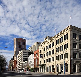
Adelaide city centre is the inner city locality of Greater Adelaide, the capital city of South Australia. It is known by locals simply as "the City" or "Town" to distinguish it from Greater Adelaide and from the City of Adelaide local government area. The population was 15,115 in the 2016 census.

Until 1958, trams formed a network spanning most of Adelaide, with a history dating back to 1878. Adelaide ran horse trams from 1878 to 1914 and electric trams from 1909, but has primarily relied on buses for public transport since the mid-20th century. Electric trams, and later trolleybuses, were Adelaide's main method of public transport throughout the life of the electric tram network. The tram network was progressively closed down through the 1950s with the last lines closing in 1958; the Glenelg tram line was the only line to survive these closures and has remained in operation ever since and has been progressively upgraded and extended since 2005.

Buses in Adelaide are the most extensive service of the South Australian capital's public transport system, the Adelaide Metro. A large fleet of diesel, hybrid diesel-electric, and natural gas powered buses operate services which typically terminate in the city-centre or at a suburban interchange. Buses get priority on many roads and intersections, with dedicated bus lanes and 'B'-light bus only phases at many traffic lights.

Grenfell Street is a major street in the north-east quarter of the Adelaide city centre, South Australia. The street runs west-east from King William Street to East Terrace. Its intersection with Pulteney Street is formed by Hindmarsh Square. On the west side of King William Street, it continues as Currie Street towards West Terrace.

East Terrace marks the eastern edge of the Adelaide city centre. It is one of the main north–south thoroughfares through the east side of the city. Although the terrace essentially runs north–south between North Terrace and South Terrace, unlike Adelaide's other three terraces, its path is far from a straight line; travelling the entire length of East Terrace requires turning at right angles at most intersections from Pirie Street onwards. These days however, the traffic flow, after a swerve to the east between Grenfell and Pirie Streets, continues southwards over the Pirie intersection into Hutt Street and on down to South Terrace.

North Adelaide is a predominantly residential precinct and suburb of the City of Adelaide in South Australia, situated north of the River Torrens and within the Adelaide Park Lands.

William Bakewell was a solicitor and politician in the early days of the Colony of South Australia.

Edward Howard Bakewell was a South Australian pastoralist, businessman and administrator.

Frome Street is a street in the East End of the Adelaide city centre, South Australia. It runs from North Terrace in the north to Angas Street, and then as Regent Street North to Carrington Street in the south. North of North Terrace, Frome Street continues towards North Adelaide as Frome Road.

Gawler Place is a single-lane thoroughfare in the city centre of Adelaide, the capital of South Australia. Somewhat narrower than other busy streets in the Central Business District, it runs north to south from North Terrace to Wakefield Street, parallel to and approximately midway between King William and Pulteney streets.