
North Terrace is one of the four terraces that bound the central business and residential district of Adelaide, the capital city of South Australia. It runs east–west, along the northern edge of "the square mile". The western end continues on to Port Road, and the eastern end continues across the Adelaide Parklands as Botanic Road.

Rundle Street, often referred to as "Rundle Street East" as distinct from Rundle Mall, is a street in the East End of the city centre of Adelaide, the capital of South Australia. It runs from Pulteney Street to East Terrace, where it becomes Rundle Road through the East Park Lands. The street is close to Adelaide Botanic Gardens, Rundle Park, Rymill Park, Hindmarsh Square and North Terrace.
Grand Junction Road is the longest east–west thoroughfare in the Adelaide metropolitan area, traversing through Adelaide's northern suburbs approximately 8 kilometres north of the Adelaide city centre.
Hindmarsh Square/Mukata is one of five public squares in the Adelaide city centre, South Australia. It is located in the centre of the north-eastern quarter of the city, and surrounds the intersection of Grenfell and Pulteney streets, near the eastern end of the Rundle Mall. Pirie Street forms the southern boundary of the square.

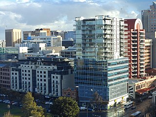
Adelaide city centre is the inner city locality of Greater Adelaide, the capital city of South Australia. It is known by locals simply as "the City" or "Town" to distinguish it from Greater Adelaide and from the City of Adelaide local government area. The population was 15,115 in the 2016 census.

Hurtle Square, also known as Tangkaira, is one of five public squares in the Adelaide city centre, South Australia. Located in the centre of the south-eastern quarter of the city, it surrounds the intersection of Halifax and Pulteney streets. Its north edge is bounded by Carrington Street.

Gouger Street is a major street in the centre of Adelaide, South Australia. It was named after Robert Gouger, the first Colonial Secretary of South Australia.

Pulteney Street is a main road which runs north-south through the middle of the eastern half of the Adelaide city centre, in Adelaide, South Australia. It runs north-south from North Terrace, through Hindmarsh and Hurtle Squares, to South Terrace, where it becomes Unley Road. It is the only one of the city centre's major north-south thoroughfares that does not continue northwards over North Terrace.

Halifax Street is a street in the south-eastern sector of the centre of Adelaide, South Australia. It runs east–west between East Terrace and King William Street, crossing Hutt Street and Pulteney Street and passing through Hurtle Square. It was named after Sir Charles Wood, British Member of Parliament for Halifax.
The Street Naming Committee was a committee established to decide on names for the streets of the new city of Adelaide in the colony of South Australia in 1837.
Carrington Street is a street in the south-eastern sector of the centre of Adelaide, South Australia. It runs east–west, from East Terrace to King William Street, blocked at Hutt Street and crossing Pulteney Street at Hurtle Square. It is one of the narrow streets of the Adelaide grid, at 1 chain wide.

Pirie Street is a road on the east side of the Adelaide city centre, South Australia. It runs east–west, between East Terrace and King William Street. After crossing King William Street, it continues as Waymouth Street. It forms the southern boundary of Hindmarsh Square which is in the centre of the north-east quadrant of the city centre.

Grenfell Street is a major street in the north-east quarter of the Adelaide city centre, South Australia. The street runs west-east from King William Street to East Terrace. Its intersection with Pulteney Street is formed by Hindmarsh Square. On the west side of King William Street, it continues as Currie Street towards West Terrace.

Sturt Street is a street in the south-western sector of the centre of Adelaide, South Australia. It runs east-west between West Terrace to King William Street, passing through Whitmore Square. After crossing King William Street, it continues as Halifax Street.

Grote Street is a major street running east to west in the western half of Adelaide city centre, South Australia. It is on the northern border of Chinatown and the Adelaide Central Market, and is a lively centre for shopping and restaurants. The historic Her Majesty's Theatre is located here.

Pulteney Grammar School is an independent, Anglican, co-educational day school. Founded in 1847 by members of the Anglican Church, it is the second oldest independent school in South Australia. It is located on South Terrace in Adelaide.

Franklin Street is a main street in the Adelaide city centre, South Australia.
Waymouth Street, often spelt as Weymouth Street in the early days, is an east–west street running between King William Street and West Terrace in the Adelaide city centre in South Australia. The street is named after Henry Waymouth, a founding director of the South Australian Company, whose name was also sometimes spelt as Weymouth.
Currie Street is a main street in the Adelaide city centre, South Australia. It runs east–to–west from King William Street, through Light Square, to West Terrace on the western edge of the city centre.

Flinders Street is a main street in the city centre of Adelaide, South Australia. It runs from the northern end of Victoria Square to East Terrace. It is one of the intermediate-width streets of the Adelaide grid, at 1+1⁄2 chains wide.


