City of Henley and Grange

Last updated

City of Henley and Grange
South Australia
Australia South Australia location map.svg
Red pog.svg
City of Henley and Grange
Coordinates 34°55′01″S138°29′38″E / 34.91694°S 138.49389°E / -34.91694; 138.49389
Population6,000 (1936) [1] :250
 • Density520/km2 (1,330/sq mi)
Established2 December 1915 [2]
Abolished1 January 1997 [3]
Area11.65 km2 (4.5 sq mi) [1] :250
Council seat Henley Beach
LGAs around City of Henley and Grange:
Woodville Woodville
City of Henley and Grange Woodville
West Torrens
West Torrens West Torrens

The City of Henley and Grange was a local government area in South Australia from 1915 to 1997, seated at the Adelaide seaside suburb of Henley Beach.

Contents

At the time of its establishment, it comprised four wards, each spanning the width of the local government area. From north to south they were: Grange, Kirkcaldy, Henley and South Henley. [2]

History

On 2 December 1915, the seaside communities of Henley Beach and Grange in the District Council of Woodville and West Beach in the District Council of West Torrens seceded to form the Municipality of Henley and Grange. [2]

In 1936, it covered an area of 4.5 square miles (12 km2) and had an estimated population of 6,000 people. [1] :250

On 11 June 1970, it was declared to be a city with the municipality being named "The City of Henley and Grange" and the corporation being named “The Corporation of the City of Henley and Grange". [4]

On 1 January 1997, the City of Henley and Grange was amalgamated with the City of Hindmarsh Woodville to form the present-day City of Charles Sturt. [3]

The old Henley Civic Centre on the corner of North Street and Seaview Road, Henley Beach, now houses the Henley Beach Library branch of the Charles Sturt Library Service.[ citation needed ]

Neighbouring local government

The following adjacent local government bodies co-existed with the Henley and Grange council:

Mayors

The following persons were elected to serve as mayor for the following terms:

Related Research Articles

<span class="mw-page-title-main">Grange, South Australia</span> Suburb of Adelaide, South Australia

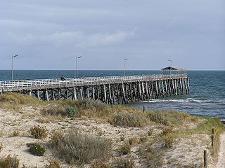
Grange is a coastal suburb of the City of Charles Sturt, in Adelaide, South Australia, located about 11 kilometres (6.8 mi) from the Adelaide city centre. The suburb is named after Captain Charles Sturt's cottage, built in 1840–41, which still stands and is now a museum. In addition to Grange Beach, the suburb has several parks and reserves, as well as the Grange Hotel, which was originally licensed in 1881.

<span class="mw-page-title-main">Woodville, South Australia</span> Suburb of Adelaide, South Australia

Woodville is a suburb of Adelaide, situated about 8 km (5 mi) north-west of the Adelaide city centre. It lies within the City of Charles Sturt. The postcode of Woodville is 5011. Woodville is bound by Cheltenham Parade to the west, Torrens Road to the north, Port Road to the south and Park Street to the east, excluding the area of Cheltenham Park Racecourse. The population was 2,180 at the 2021 Australian census.

<span class="mw-page-title-main">Torrensville, South Australia</span> Suburb of Adelaide, South Australia

Torrensville is a western suburb 3 km (1.9 mi) west of the centre of Adelaide, South Australia. It was named after Irish-born economist and chairman of the South Australian Colonisation Commission, Robert Torrens.

South Road and its southern section as Main South Road outside of Adelaide is a major north–south conduit connecting Adelaide and the Fleurieu Peninsula, in South Australia. It is one of Adelaide's most important arterial and bypass roads. As South Road, it is designated part of route A2 within suburban Adelaide. As Main South Road, it is designated part of routes A13 and B23.

<span class="mw-page-title-main">City of Charles Sturt</span> Local government area in South Australia

The City of Charles Sturt is a local government area in the western suburbs of Adelaide, South Australia, stretching to the coast.

<span class="mw-page-title-main">Brompton, South Australia</span> Suburb of Adelaide, South Australia

Brompton is an inner-northern suburb of Adelaide, South Australia in the City of Charles Sturt.

<span class="mw-page-title-main">Henley Beach, South Australia</span> Suburb of Adelaide, South Australia

Henley Beach is a coastal suburb of Adelaide, South Australia in the City of Charles Sturt.

<span class="mw-page-title-main">Ovingham, South Australia</span> Suburb of Adelaide, South Australia

Ovingham is an inner northern suburb of Adelaide, South Australia. It is located in the cities of Charles Sturt and Prospect.

Fulham Gardens is a western suburb of Adelaide, South Australia in the City of Charles Sturt.

<span class="mw-page-title-main">Kilkenny, South Australia</span> Suburb of Adelaide, South Australia

Kilkenny is an inner north-western suburb of Adelaide, South Australia. It is located in the City of Charles Sturt. It is named after Kilkenny, Ireland.

<span class="mw-page-title-main">Hindmarsh, South Australia</span> Suburb of Adelaide, South Australia

Hindmarsh is an inner suburb of Adelaide, South Australia. It is located in the City of Charles Sturt.

<span class="mw-page-title-main">Hundred of Adelaide</span> Cadastral in South Australia

The Hundred of Adelaide is a cadastral hundred in the city of Adelaide spanning all the inner suburbs south of River Torrens. It is one of the eleven hundreds of the County of Adelaide, and was one of the first hundreds to be proclaimed. Like the city it surrounds, the Hundred was named after Queen Adelaide, and was named by Governor Frederick Robe in 1846. It is 106 square miles (270 km2); close to but not exactly one hundred square miles as with most of the other hundreds. Its north boundary is the Torrens River and the Sturt River forms the south east boundary, with the hundred extending to the Adelaide foothills.

<span class="mw-page-title-main">Henley Beach South, South Australia</span> Suburb of Adelaide, South Australia

Henley Beach South is a coastal suburb of Adelaide, South Australia. It is located in the City of Charles Sturt.

<span class="mw-page-title-main">Croydon, South Australia</span> Suburb of Adelaide, South Australia

Croydon is an inner western suburb of Adelaide, South Australia. It is located in the City of Charles Sturt.

Hindmarsh was an electoral district of the House of Assembly in the Australian state of South Australia from 1938 to 1970. It was in the northwestern suburbs of Adelaide.

The City of Hindmarsh Woodville was a local government area in South Australia from 1993 to 1997 seated at the inner north west Adelaide suburbs of Hindmarsh and Woodville.

The District Council of Hindmarsh was a local government area in South Australia from 1853 to 1875, seated at the inner north west Adelaide suburb of Hindmarsh.

<span class="mw-page-title-main">City of Woodville</span> Local government area in South Australia

The City of Woodville was a local government area in South Australia from 1875 to 1993, seated at the inner north west Adelaide suburb of Woodville.

Grange Road is an arterial road in the western suburbs of Adelaide, South Australia. It runs from the coast at Grange to South Road, close to the city centre.

References

  1. 1 2 3 4 5 Hosking, P. (1936), The Official civic record of South Australia : centenary year, 1936, Universal Publicity Company, pp. 248–259, retrieved 16 November 2015
  2. 1 2 3 4 "Municipality of Henley and Grange" (PDF). South Australian Government Gazette (49 ed.). Government of South Australia. 1915: 1519. 2 December 1915. Retrieved 31 July 2017.
  3. 1 2 Ashenden, E.S. (12 December 1996). "LOCAL GOVERNMENT ACT 1934 SECTIONS 7 AND 14: AMALGAMATION OF THE CITY OF HENLEY AND GRANGE AND THE CITY OF HINDMARSH AND WOODVILLE" (PDF). The South Australian Government Gazette. Government of South Australia. pp. 1852–1853. Retrieved 21 July 2019. 17. Declare that this proclamation will come into operation on 1 January 1997.
  4. Virgo, G.T. (11 June 1970). "LOCAL GOVERNMENT ACT, 1934-1969: THE CITY OF HENLEY AND GRANGE AND CORPORATION THEREOF" (PDF). The South Australian Government Gazette. Government of South Australia. p. 2060. Retrieved 21 July 2019.
  5. 1 2 "State Bank Changes". The Register (Adelaide) . Vol. LXXXVI, no. 23, 145. South Australia. 12 January 1921. p. 7. Retrieved 22 July 2019 via National Library of Australia.
  6. "In Other Towns". Recorder. No. 3271. South Australia. 8 December 1919. p. 1. Retrieved 22 July 2019 via National Library of Australia.
  7. "READY FOR BOWLS". The News . Vol. VII, no. 1, 015. South Australia. 14 October 1926. p. 11. Retrieved 22 July 2019 via National Library of Australia.
  8. "Henley Recreation Carnival". The Advertiser . South Australia. 27 February 1928. p. 7. Retrieved 22 July 2019 via National Library of Australia.
  9. "Mr. H. Gaetjens". Chronicle . Vol. LXXVII, no. 4, 089. South Australia. 28 March 1935. p. 14. Retrieved 21 July 2019 via National Library of Australia.
  10. Cameron, Clyde (1993). "Chambers, Cyril (1897–1975)". Australian Dictionary of Biography . National Centre of Biography, Australian National University. ISSN   1833-7538 . Retrieved 21 July 2019.
  11. "Henley-Grange Approve Trunks". The News . Vol. XXX, no. 4, 522. South Australia. 20 January 1938. p. 1. Retrieved 22 July 2019 via National Library of Australia.
  12. "Henley Presentation". The Advertiser (Adelaide) . Vol. 93, no. 28, 676. South Australia. 6 September 1950. p. 3. Retrieved 22 July 2019 via National Library of Australia.