
Snowtown is a town located in the Mid North of South Australia 145 km north of Adelaide and lies on the main road and rail routes between Adelaide and Perth — the Augusta Highway and Adelaide-Port Augusta railway line. The town's elevation is 103 metres and on average the town receives 389 mm of rainfall per annum.
The City of Prospect is an inner urban local government area (LGA) in Adelaide, South Australia. The council seat is the unusually-large suburb of Prospect, which makes up almost two thirds of the tiny council area which is less than 8km2. Established in 1872, it is one of the oldest local government bodies in South Australia.

Meningie is a town on the south-east side of Lake Albert in South Australia. It is on the Princes Highway near The Coorong and was surveyed in 1866. At the 2016 census, the locality of Meningie had a population of 1118 with a median age of 51 while its town centre had a population of 852.

Hindmarsh is an inner suburb of Adelaide, South Australia. It is located in the City of Charles Sturt.

Glanville is a north western suburb of Adelaide, in the City of Port Adelaide Enfield.

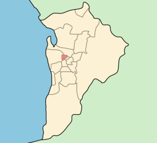
Clinton is a locality in the Australian state of South Australia located on the east coast of Yorke Peninsula overlooking the north west head of Gulf St Vincent about 101 kilometres (63 mi) west of the state capital of Adelaide and about 36 kilometres (22 mi) north-east of the municipal seat of Maitland.

Pooraka is a suburb in Adelaide, South Australia. It is 12 kilometres north of the central business district.

Mambray Creek is a locality in the Australian state of South Australia located on the east coast of Spencer Gulf about 240 kilometres (150 mi) north of the state capital of Adelaide and about 40 kilometres (25 mi) north of the city of Port Pirie.
Port Gawler is a locality and former port on Gulf St Vincent on the central Adelaide Plains in South Australia. Port Gawler is located 43 kilometres (27 mi) north west of Adelaide in the Adelaide Plains Council local government area at the mouth of the Gawler River.
The City of Port Adelaide was a local government area of South Australia centred at the port of Adelaide from 1855 to 1996.
The District Council of Yatala was a local government area of South Australia established in 1853 and abolished in 1868.
Torrens Island Conservation Park is a protected area in the Australian state of South Australia located on Torrens Island in the Adelaide metropolitan area about 17 kilometres north-northwest of the state capital of Adelaide and about 3.9 kilometres north-northeast of Port Adelaide.
The District Council of Glanville was a local government area in South Australia from 1864 to 1888.

The Hundred of Yatala is a cadastral unit of hundred in South Australia covering much of the Adelaide metropolitan area north of the River Torrens. It is one of the eleven hundreds of the County of Adelaide stretching from the Torrens in the south to the Little Para River in the north; and spanning from the coast in the west to the Adelaide foothills in the east. It is roughly bisected from east to west by Dry Creek. It was named in 1846 by Governor Frederick Robe, Yatala being likely derived from 'yartala', an indigenous word referring to the flooded state of the plain either side of Dry Creek after heavy rain.

The Hundred of Port Adelaide is a cadastral hundred covering the vicinity of Port Adelaide, Lefevre Peninsula and the coast of the central Adelaide Plains south of Gawler River and west of Port Wakefield Road. It is one of the eleven hundreds of the County of Adelaide and was named in 1846 by Governor Frederick Robe.
The District Council of Hindmarsh was a local government area in South Australia from 1853 to 1875, seated at the inner north west Adelaide suburb of Hindmarsh.
The District Council of Queenstown and Alberton was a local government area of South Australia established in 1864 and abolished in 1898.
The District Council of Kondoparinga was a local government area in South Australia from 1853 until 1935, at which point the council lands and resources formed the heart of the new District Council of Meadows.
Sandy Creek Conservation Park, formerly the Sandy Creek National Park, is a protected area located in the Australian state of South Australia in the localities of Lyndoch and Sandy Creek about 42 kilometres (26 mi) north-east of the state capital of Adelaide and about 3 kilometres (1.9 mi) west-south-west of the town centre in Sandy Creek.
James Philcox was an English land speculator and property developer in the 1840s and 1850s in the colony of South Australia. He is credited with naming the inner eastern Adelaide suburb of Marryatville as well as the outer northern suburb of Evanston. He returned to England to retire in Sussex in 1853.
