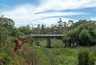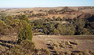
Crystal Brook is a town in the Mid North of South Australia, 197 kilometres north of the capital, Adelaide. According to the 2021 Census, the population of the town was 1,322. Crystal Brook is in a very picturesque location, being at the start of the Flinders Ranges. The town has multiple viewing points and parks. It was named after the spring-fed creek next to which it was founded.

The Port Pirie Regional Council (PPRC) is a local government area in South Australia, focused on the city of Port Pirie. It has a population of about 18,000 people. The council's main administrative facilities and works depot can be found in Port Pirie; it also have a rural office in Crystal Brook. In addition to Port Pirie, the municipality also includes the surrounding towns and localities of Bungama, Collinsfield, Coonamia, Crystal Brook, Koolunga, Lower Broughton, Merriton, Napperby, Nelshaby, Pirie East, Port Davis, Port Pirie South, Port Pirie West, Redhill, Risdon Park, Risdon Park South, Solomontown, Wandearah East, Wandearah West and Warnertown, and part of Clements Gap, and Mundoora.

Redhill is a town in the Mid North of South Australia adjacent to the Broughton River.

The Adelaide Plains Council is a local government area in South Australia. It consists of a largely rural region along the Gulf St Vincent, covering a total area of approximately 926 km2. The council seat lies at Mallala, but it also maintains a service centre at Two Wells.
Stanley was an electoral district of the House of Assembly in the Australian state of South Australia.
Rocky River was an electoral district of the House of Assembly in the Australian state of South Australia from March 1938 to December 1985.
The District Council of Rocky River was a local government area in South Australia from 1988 to 1997, seated at Gladstone.
The District Councils Act 1887 was an act of the Parliament of South Australia. It received assent on 9 December 1887, and its provisions came into effect when proclaimed by Governor William C. F. Robinson on 5 January 1888.
The District Council of Georgetown was a local government area in South Australia, centred on the town of Georgetown.
The District Council of Laura was a local government area in South Australia. It was created on 1 May 1932 with the amalgamation of the Corporate Town of Laura and the District Council of Booyoolie. It reunited the whole cadastral Hundred of Booyoolie within the same district council, as had previously been the case when the Booyoolie council was first proclaimed in 1876. The Laura merger had occurred after a much broader 1931 merger proposal, which would have seen the Corporate Town of Laura, District Council of Gladstone, Corporate Town of Gladstone and District Council of Caltowie merge into a drastically enlarged District Council of Booyoolie, was abandoned after meeting strong opposition from both the Laura and Gladstone communities.
The District Council of Gladstone was a local government area in South Australia. It was proclaimed on 10 August 1876 as the District Council of Yangya, named for the cadastral Hundred of Yangya, but was renamed Gladstone after its main town on 14 August 1879. Gladstone had been built as a private township very close to the hundred boundary, and the adjacent government township of Booyoolie, built not long after, was in the adjacent Hundred of Booyoolie, and formed as the separate District Council of Booyoolie, dividing the twin towns into two separate municipalities based on their respective hundreds. It gained the Booyoolie township from that council in 1879, and acquired the remainder of what had been the southern portion of the Booyoolie council on 12 August 1880. It then gained the remainder of the Hundred of Yangya under the District Councils Act 1887.
The District Council of Crystal Brook was a local government area in South Australia from 1882 until 1988, seated at Crystal Brook.

The District Council of Booyoolie was a local government area in South Australia. It was proclaimed on 2 March 1876 and comprised the entire cadastral Hundred of Booyoolie. It included at its inception the government town of Booyoolie, North Gladstone, Laura and Stone Hut. It was divided into five wards, each electing one councillor. In September 1876, the council decided to construct a council office and chamber at Laura.
The District Council of Redhill was a local government area in South Australia from 1888 to 1988.
The District Council of Pirie was a local government area in South Australia from 1892 to 1996. It surrounded, but did not include, the city of Port Pirie, which had its own municipal government as the City of Port Pirie.
The City of Port Pirie was a local government area in South Australia from 1876 to 1997, centred on the city of Port Pirie.
The District Council of Port Broughton was a local government area in South Australia from 1892 to 1997 seated at the town of Port Broughton.
The District Council of Snowtown was a local government area in South Australia from 1888 to 1987.

The Hundred of Crystal Brook is a cadastral unit of hundred located in the Mid North of South Australia in the approach to the lower Flinders Ranges. It is one of the hundreds of the County of Victoria and was named by Governor James Fergusson after the stream of the same name which flows east to west near the northern border of the hundred.
The Hundred of Redhill is a cadastral unit of hundred located in the Mid North of South Australia spanning the northern Barunga Range. It is one of the 16 hundreds of the County of Daly and was named in 1869 by Governor James Fergusson after the same hill giving rise to the name for the township of Redhill, uphill from the west bank of the Broughton River.


