
Mount Barker is a city in South Australia. Located approximately 33 kilometres from the Adelaide city centre, it is home to 16,629 residents. It is the seat of the District Council of Mount Barker, the largest town in the Adelaide Hills, and one of the fastest growing areas in the state.

The South Eastern Freeway is a 76 kilometre controlled-access highway in South Australia. It carries traffic over the Adelaide Hills between Adelaide and the River Murray, near Murray Bridge, connecting via the Swanport Bridge to the Dukes Highway which is the main road route to Victoria. It is often referred to by South Australians simply as the Freeway, as it was the first freeway in South Australia, and is still the longest, and the only one with "Freeway" in its name rather than "Expressway" or "Highway". It is a part of the National Highway network linking the state capital cities Adelaide to Melbourne and signed as National Highway M1. The South Eastern Freeway includes 500-metre-long twin-tube tunnels in the descent towards Adelaide, the first of their kind on the National Highway. It is designated as the M1.

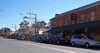
Hahndorf is a small town in the Adelaide Hills region of South Australia. Currently an important tourism spot, it has previously been a centre for farming and services.

The Mount Barker District Council is a local government area centred on the town of Mount Barker just outside the Adelaide metropolitan area in South Australia.
Nairne is a small township in the Adelaide Hills of South Australia. Nairne is about 7 kilometres (4 mi) from Mount Barker, South Australia, in the federal Division of Mayo and in the state electoral district of Kavel. At the 2016 census, Nairne had a population of 4,842.
St Francis de Sales College is a Reception to Year 12 Catholic co-educational school located in Mount Barker, South Australia.

The County of Sturt is one of the 49 cadastral counties of South Australia. It was proclaimed by Governor George Grey in 1842 and named for early Australian explorer, Charles Sturt. It stretches from the Bremer River and eastern slopes of the Adelaide Hills at Nairne and Tungkillo to the Murray River in the east and in the south, the portion of Lake Alexandrina north of a line from Point Sturt to Pomanda Island. This includes the west-of-river parts of the contemporary local government areas of the Mid Murray Council and Murray Bridge City.

John Dunn Sr. was a flour miller in the early days of the colony of South Australia; a parliamentarian, philanthropist and a prominent citizen of Mount Barker, South Australia.
William Bower Dawes was a farmer in the colony of South Australia, and member of the first fully elected House of Assembly.

The District Council of East Torrens was a local government council of South Australia from 1853 to 1997.

The Hundred of Monarto is a cadastral unit of hundred, the centre of which lies about 47 kilometres (29 mi) east southeast of Adelaide in South Australia and about 19 kilometres (12 mi) west of the Murray River. One of the ten hundreds of the County of Sturt, it is bounded on the west by the Bremer River, with the north west corner being set at the point where Mount Barker Creek merges with the river. It was named in 1847 by Governor Frederick Robe after "Queen Monarto", an aboriginal woman who lived at the time in the area. According to John Wrathall Bull, in his writings on early South Australia history, she was the lubra (partner) of aboriginal tribal leader "King John", whose tribe resided "on the banks of the Murray" at the time.
The District Council of Mobilong was a local government area in South Australia from 1884 to 1977.
The Corporate Town of Murray Bridge was a local government area in South Australia from 1924 to 1977.

The Hundred of Kanmantoo is a cadastral unit of hundred in the eastern Adelaide Hills. One of the 10 hundreds of the County of Sturt, it was proclaimed on 13 November 1847 by Governor Frederick Robe and named after the Kanmantoo gold mine, itself presumed to be named after an indigenous term by William Giles.
The Local Government Areas (Re-arrangement) Acts 1929 and 1931 were acts of the Parliament of South Australia. The application of the acts, via recommendations of the commission of the same name, led to the statewide re-arrangement of local government areas, effected from 1932 to 1935.
The District Council of Grace was a local government area in South Australia from 1874 to 1935, seated at Mallala.
The District Council of Kondoparinga was a local government area in South Australia from 1853 until 1935, at which point the council lands and resources formed the heart of the new District Council of Meadows.
The District Council of Strathalbyn was a local government area in South Australia centred on the town of Strathalbyn from 1854 until 1997. From 1868 the township itself was locally governed by the Corporation of Strathalbyn but that entity was amalgamated back into the district council in 1976.
The District Council of Peake was a local government area in the Australian state of South Australia that existed from 1911 to 1997 on land in the state’s south-east.
