
The City of Payneham, formerly the District Council of Stepney, was a local government area in South Australia from 1867 to 1997.
The City of Payneham, formerly the District Council of Stepney, was a local government area in South Australia from 1867 to 1997.
The District Council of Stepney was proclaimed on 25 July 1867, separating from the original District Council of Payneham. It was divided into five wards: Hackney, Stepney, Payneham, Marden and Stepney North. [1] On 27 February 1868, the original Payneham council was renamed the District Council of Campbelltown, and when the western part of the Stepney council was severed to form the Corporate Town of St Peters on 30 August 1883, the remainder of the Stepney council assumed the District Council of Payneham name. [2] [3] The council rented offices at the Payneham Institute, and met at the Masonic Lodge Hall. [3]
It became a municipal corporation on 1 October 1945 as the Corporate Town of Payneham, and gained city status as the City of Payneham on 28 November 1964, when the population officially exceeded 15,000. In 1964, the council opened the new Civic Centre, containing council offices, a library and two community halls. In the 1960s and 1970s, it was involved in developing a series of community facilities: Adey Reserve (1961), Patterson Reserve (1966) and clubrooms (1970), Payneham Memorial Swimming Centre (1968), Payneham and District Senior Citizens Centre (1972), Drage Reserve (1974) and the Payneham Youth Centre (1978). A new Payneham Public Library was opened in 1980, and the Payneham Community Centre opened in 1984. [3]
In 1985, it covered an area of 7.1 square kilometres, with a population of 16,502 as of the 1981 census, down from 17,543 in 1971. It had significant communities of both elderly residents (19% of the population) and people from Italian backgrounds (approximately 14% born in Italy, with an estimated 40% of Italian descent). [3]

The 1973-1975 Royal Commission into Local Government Areas had recommended that the St Peters council merge back into Payneham, but this was rejected at the time. However, pressure for the smaller inner-city municipalities to merge continued, and on 1 November 1997 it amalgamated with the City of Kensington and Norwood and the Town of St Peters to form the City of Norwood Payneham & St Peters. [4] [3]
Maylands is a suburb of Adelaide located within the City of Norwood Payneham St Peters, and bounded by the main roads Portrush Road and Magill Road.

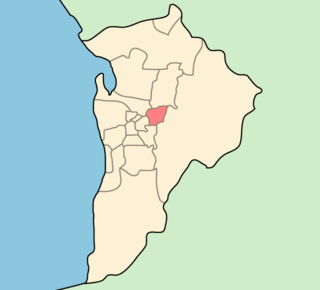
The City of Norwood Payneham & St Peters is a metropolitan local government area of South Australia. It covers the inner eastern suburbs of Adelaide. It is divided into five wards: Torrens, Payneham, West Norwood/Kent Town, Kensington, and Maylands/Trinity. The council is based at the historic Norwood Town Hall. Comprising the council is a mayor and 13 elected members, who are supported by a chief executive, as well as four general managers and approximately 175 field and inside staff.
Norwood is a suburb of Adelaide, about 4 km east of the Adelaide city centre. The suburb is in the City of Norwood Payneham & St Peters, the oldest South Australian local government municipality, with a city population over 34,000. It has become an extremely popular place to live and housing prices reflect accordingly.

St Peters is an inner-eastern suburb of Adelaide, South Australia in the City of Norwood Payneham St Peters.
Payneham South is a suburb of Adelaide in the City of Norwood Payneham St Peters. It has traditionally been market gardens but is currently undergoing a building boom in which many smaller houses are being built.
Kent Town is an inner urban suburb of Adelaide, South Australia. It is located in the City of Norwood Payneham & St Peters.
Marden is a suburb of Adelaide, South Australia in the City of Norwood Payneham St Peters. The suburb is bordered by the River Torrens to the north, O.G. Rd to the east, Payneham Rd to the south and Battams Rd to the west.
Payneham is an eastern suburb of Adelaide in the City of Norwood Payneham St Peters. It is part of a string of suburbs in Adelaide's east with a high proportion of Adelaide's Italian-Australian and French-Australian residents, many of whom can be traced back to the large-scale migration following the Second World War. but not all of them because some of them are younger.

Stepney is a small triangular near-city suburb of Adelaide within the City of Norwood Payneham & St Peters. Stepney contains a mix of retail, manufacturing, professional services and distribution outlets within a cosmopolitan population strongly influenced by post World War II immigration.
Trinity Gardens is a suburb of Adelaide, South Australia. The name is taken from Holy Trinity Church.
The City of Campbelltown is a local government area in the north eastern suburbs of Adelaide, South Australia about 6 kilometres from the Adelaide GPO. The city is bordered by the River Torrens and the City of Tea Tree Gully, the District of Adelaide Hills, the City of Burnside, the City of Norwood Payneham St Peters, and the City of Port Adelaide Enfield.

The history of the City of Burnside, a local government area in the metropolitan area of Adelaide, spans three centuries. Prior to European settlement Burnside was inhabited by the Kaurna people, who lived around the creeks of the River Torrens during the winter and in the Adelaide Hills during the summer.
Norwood is a former electoral district of the House of Assembly in the Australian state of South Australia. It was a 14.2 km² inner urban electorate in Adelaide and was named after the inner-eastern suburb of Norwood. In its final configuration, the seat also included the suburbs of Beulah Park, College Park, Evandale, Firle, Hackney, Joslin, Kent Town, Marden, Maylands, Payneham South, Royston Park, St Morris, St Peters, Stepney, Trinity Gardens and Vale Park, as well as parts of Kensington, Klemzig and Payneham.
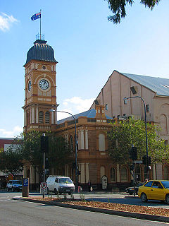
The Norwood Town Hall is the council seat of the City of Norwood Payneham & St Peters. It is located on The Parade in the suburb of Norwood, Adelaide, Australia, five minutes east of the city centre.
Gilberton is an inner northern suburb of Adelaide, South Australia on the northern bank of the River Torrens a short distance from Adelaide's city centre. It is bounded by the river, Park terrace, Stephen Terrace and Northcote Terrace. The suburb is largely residential with some large and ornate Victorian homes and approximately 2 kilometres (1 mi) of the Torrens Linear Park as its southern boundary. The large homes in the suburb's northern section give it a historic character that is protected by Government planning regulations.

The Burnside Library is located on the corner of Greenhill and Portrush Roads and is part of the Burnside Civic Centre. The library was one of the first public libraries in South Australia, opening its doors to the public on 8 April 1961. In 2000, the library and the civic centre underwent a major renovation. This has served to make the library a bright, open and attractive space for the community. As with other public libraries, Burnside Library has changed dramatically over the years. As of 2010 it has 26 computers, free wireless access, and over 6,000 DVDs available to the public. It has more than 1,000 visitors a day and approximately 65% of all residents are registered borrowers. The library collection contains more 135,000 across 2,200 square metres of floor space. In 2015 there were 910,000 item loans.
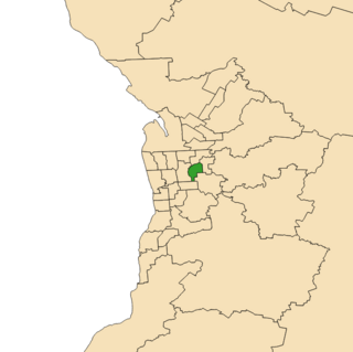
Dunstan is a single-member electoral district for the South Australian House of Assembly, covering the inner eastern suburbs of College Park, Dulwich, Evandale, Felixstow, Firle, Glynde, Hackney, Joslin, Marden, Maylands, Norwood, Payneham, Payneham South, Rose Park, Royston Park, St Morris, St Peters, Stepney, and Trinity Gardens.
The District Council of East Torrens was a local government council of South Australia from 1853 to 1997.
The City of Kensington and Norwood, originally the Corporate Town of Kensington and Norwood, was a local government area in South Australia from 1853 to 1997, centred on the inner eastern Adelaide suburbs of Kensington and Norwood. In November 1997 it amalgamated with the City of Payneham and the Town of St Peters to form the City of Norwood Payneham & St Peters.
The Corporate Town of St Peters was a local government area in South Australia from 1883 to 1997.
Coordinates: 34°53′44″S138°38′31″E / 34.895477°S 138.641905°E