Related Research Articles
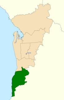
The Division of Kingston is an Australian Electoral Division in South Australia covering the outer southern suburbs of Adelaide. The 171 km² seat stretches from Hallett Cove and O'Halloran Hill in the north to Sellicks Beach in the south, including the suburbs of Aberfoyle Park, Aldinga Beach, Christie Downs, Christies Beach, Flagstaff Hill, Hackham, Hallett Cove, Huntfield Heights, Lonsdale, Maslin Beach, Moana, Morphett Vale, Old Noarlunga, Onkaparinga Hills, Port Noarlunga, Reynella, Seaford, Sellicks Beach, Sheidow Park, Port Willunga, Trott Park, Woodcroft, and parts of Happy Valley and McLaren Flat.

The City of Onkaparinga is a local government area (LGA) located on the southern fringe of Adelaide, South Australia. It is named after the Onkaparinga River, whose name comes from Ngangkiparinga, a Kaurna word meaning women's river. It is the largest LGA in South Australia, with a population of over 170,000 people in both urban and rural communities and is also geographically expansive, encompassing an area of 518.3 km². The council is headquartered in the Noarlunga Centre with area offices situated in Aberfoyle Park, Woodcroft and Willunga.
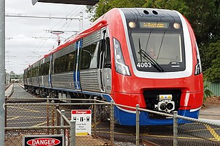
The Seaford railway line is a suburban commuter line in Adelaide, South Australia.

Old Noarlunga is a suburb in the Australian state of South Australia located about 30 kilometres (19 mi) south of the state capital of Adelaide. Originally settled around 1840, the town retains its village atmosphere in spite of encroaching suburbia.
The Southern Football League (SFL) is an Australian rules football league in South Australia. The League was formed, as the Southern Football Association, in 1886.

McLaren Vale is a town and locality in the Australian state of South Australia located about 33 kilometres (21 mi) south of the Adelaide city centre and about 9 kilometres (5.6 mi) south of the municipal seat at Noarlunga Centre.

Sellicks Beach, formerly spelt Sellick's Beach, is a suburb in the Australian state of South Australia located within Adelaide metropolitan area about 47 kilometres (29 mi) from the Adelaide city centre. It is an outer southern suburb of Adelaide and is located in the local government area of the City of Onkaparinga at the southern boundary of the metropolitan area. It is known as Witawali or Witawodli by the Traditional Owners, the Kaurna people, and is of significance as being the site of a freshwater spring said to be created by the tears of Tjilbruke, the creator being.

The County of Adelaide is one of the 49 cadastral counties of South Australia and contains the city of Adelaide. It was proclaimed on 2 June 1842 by Governor Grey. It is bounded by the Gawler River and North Para River in the north, the Mount Lofty Ranges in the east, and Gulf St Vincent in the west. The south border runs from Aldinga Bay to Willunga South and Mount Magnificent.

Aldinga Beach is an outer southern suburb of Adelaide, South Australia. It lies within the City of Onkaparinga and has the postcode 5173. At the 2016 census, Aldinga Beach had a population of 10,557. It lies about a kilometre west of the smaller suburb of Aldinga. The beach is a well-known spot for surfing, swimming, scuba diving, and snorkelling during the summer months. It overlooks an aquatic reserve which has been created to safeguard a unique reef formation.
Southern Times Messenger is a weekly suburban newspaper in Adelaide, part of the Messenger Newspapers group. The Southern Times' area stretches from Lonsdale in the north, through to Sellicks Beach in the south, and covers the southern suburbs, accessible from the city via Main South Road and the more recently constructed Southern Expressway. The newspaper generally reports on events of interest in its distribution area, including the suburbs of Morphett Vale, Noarlunga, Reynella and Aldinga. It also covers the City of Onkaparinga council. It has a circulation of 57,690 and a readership of 95,000.
Onkaparinga Valley Road is a South Australian secondary road, connecting the towns of Birdwood, Woodside, Balhannah, Hahndorf and Meadows in the Adelaide Hills with Willunga in the southern Adelaide metropolitan area. It is a secondary route, hence has been given the State Route designation of B34.
Aldinga Bay is a bay located on the east coast of Gulf St Vincent in South Australia about 40 kilometres south-southwest of Adelaide city centre.
The District Council of East Torrens was a local government council of South Australia from 1853 to 1997.

The Hundred of Willunga is a cadastral unit of hundred covering the extreme south suburbs of the Adelaide metropolitan area. It is one of the eleven hundreds of the County of Adelaide. It was named in 1846 by Governor Frederick Robe probably deriving from a Kaurna/Ngarrindjeri place label willannga, meaning place of green trees.
Kuitpo is a locality in the Alexandrina Council area.
The Hundred of Kuitpo is a cadastral unit of hundred in the Adelaide Hills. It is one of the 11 hundreds of the County of Adelaide. It was named in 1846 by Governor Frederick Robe and is presumed to be derived from an indigenous term ku-it-po, meaning reeds and referring to Blackfellow Creek in the contemporary locality of Yundi.

The Hundred of Noarlunga is a cadastral unit of hundred in South Australia covering the far south-western Adelaide metropolitan area south and west of the Sturt River and north and west of the Onkaparinga River. It is one of the eleven hundreds of the County of Adelaide stretching from Glenelg in the northwest to Port Noarlunga in the southwest; and spanning inland between the Sturt and Onkaparinga to Bridgewater in the Adelaide foothills. It was named in 1846 by Governor Frederick Robe, Noarlunga being likely derived from 'nurlongga', an indigenous word referring to the curvature in the Onkaparinga River at Old Noarlunga, dubbed Horseshoe Bend by European settlers.
The City of Happy Valley, formerly the District Council of Meadows, was a local government area in South Australia from 1935 until 1997.
The City of Noarlunga, formerly the District Council of Noarlunga, was a local government area in South Australia from 1856 until 1997.
The District Council of Kondoparinga was a local government area in South Australia from 1853 until 1935, at which point the council lands and resources formed the heart of the new District Council of Meadows.
References
- 1 2 3 4 5 Marsden, Susan (2012). "A History of South Australian Councils to 1936" (PDF). Local Government Association of South Australia. Retrieved 30 May 2016.
- 1 2 "Proclamation - District of Willunga" (PDF). South Australian Government Gazette (33 ed.). Government of South Australia. 1853. 18 August 1853. Retrieved 15 December 2017.
On the north the said district of Willunga is bounded by the Onkaparinga River from the mouth thereof, up to the south-east boundary line of the Hundred of Kuitpo; from thence the said district is bounded by the south-east boundary line of the said Hundred of Kuitpo, till the same reaches the Trigonometrical Station at Wickham's Hill; from thence the said district is bounded by a straight line running from the last mentioned Station to North Magnificent Trigonometrical Station; from thence the said district abuts on the boundary line of the Counties of Adelaide and Hindmarsh, from the North Magnificent Trigonometrical Station to the sea; and from thence the said district is bounded on the west by the sea to the Onkaparinga River
- ↑ Hosking, P.; Universal Publicity Company (1936), The Official civic record of South Australia : centenary year, 1936, Universal Publicity Company, p. 682, retrieved 21 July 2017
35°17′0″S138°33′0″E / 35.28333°S 138.55000°E Coordinates: 35°17′0″S138°33′0″E / 35.28333°S 138.55000°E
| | This Australian government-related article is a stub. You can help Wikipedia by expanding it. |