
The City of Port Adelaide Enfield (PAE), located across inner north and north-western suburbs of Adelaide, is one of the largest metropolitan councils within South Australia. It was established on 26 March 1996 by the amalgamation of the City of Port Adelaide and the City of Enfield.

The District Council of Lower Eyre Peninsula is a local government area located on Eyre Peninsula in South Australia. The district covers the southern tip of the peninsula, except for the small area taken up by the City of Port Lincoln.

The City of Charles Sturt is a local government area in the western suburbs of Adelaide, South Australia, stretching to the coast.
The City of West Torrens is a local government area in the western suburbs of Adelaide, South Australia. Since the 1970s, the area was mainly home to many open spaces and parks, however after the mid-1990s (1993–1995) the LGA became more residential.
The Corporation of the Town of Walkerville is a small local government area in the central suburbs of Adelaide, South Australia.

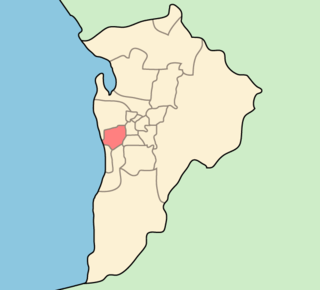
Glenelg East is a residential suburb 9 kilometres (5.6 mi) south-west of the centre of Adelaide, South Australia. It is characterised by quarter-acre blocks with heritage homes and parks intermingled with contemporary modern homes and low-rise multi-dwelling units.

The Hundred of Adelaide is a cadastral hundred in the city of Adelaide spanning all the inner suburbs south of River Torrens. It is one of the eleven hundreds of the County of Adelaide, and was one of the first hundreds to be proclaimed. Like the city it surrounds, the Hundred was named after Queen Adelaide, and was named by Governor Frederick Robe in 1846. It is 106 square miles (270 km2); close to but not exactly one hundred square miles as with most of the other hundreds. Its north boundary is the Torrens River and the Sturt River forms the south east boundary, with the hundred extending to the Adelaide foothills.
The City of Port Adelaide was a local government area of South Australia centred at the port of Adelaide from 1855 to 1996.

The City of Brighton was a local government area in South Australia seated at the Adelaide sea-side township of Brighton from 1858 until 1997.
The District Council of Yatala was a local government area of South Australia established in 1853 and abolished in 1868.

The Hundred of Yatala is a cadastral unit of hundred in South Australia covering much of the Adelaide metropolitan area north of the River Torrens. It is one of the eleven hundreds of the County of Adelaide stretching from the Torrens in the south to the Little Para River in the north; and spanning from the coast in the west to the Adelaide foothills in the east. It is roughly bisected from east to west by Dry Creek. It was named in 1846 by Governor Frederick Robe, Yatala being likely derived from yartala, a Kaurna word referring to the flooded state of the plain either side of Dry Creek after heavy rain.
The District Council of East Torrens was a local government council of South Australia from 1853 to 1997.

The City of Kensington and Norwood, originally the Corporate Town of Kensington and Norwood, was a local government area in South Australia from 1853 to 1997, centred on the inner eastern Adelaide suburbs of Kensington and Norwood. In November 1997 it amalgamated with the City of Payneham and the Town of St Peters to form the City of Norwood Payneham & St Peters.

The Town of Thebarton was a local government area of South Australia from 1883 until 1997. It was seated at the village of Thebarton, now an inner west suburb of Adelaide.
The District Council of Hindmarsh was a local government area in South Australia from 1853 to 1875, seated at the inner north west Adelaide suburb of Hindmarsh.

The Town of Hindmarsh was a local government area in South Australia from 1874 to 1993, encompassing on the inner north west Adelaide suburbs of Hindmarsh, Bowden and Brompton.

The City of Woodville was a local government area in South Australia from 1875 to 1993, seated at the inner north west Adelaide suburb of Woodville.
The City of Henley and Grange was a local government area in South Australia from 1915 to 1997, seated at the Adelaide seaside suburb of Henley Beach.
The District Council of Queenstown and Alberton was a local government area of South Australia established in 1864 and abolished in 1898.

The Hundred of Noarlunga is a cadastral unit of hundred in South Australia covering the far south-western Adelaide metropolitan area south and west of the Sturt River and north and west of the Onkaparinga River. It is one of the eleven hundreds of the County of Adelaide stretching from Glenelg in the northwest to Port Noarlunga in the southwest; and spanning inland between the Sturt and Onkaparinga to Bridgewater in the Adelaide foothills. It was named in 1846 by Governor Frederick Robe, Noarlunga being likely derived from 'nurlongga', an indigenous word referring to the curvature in the Onkaparinga River at Old Noarlunga, dubbed Horseshoe Bend by European settlers.

