
Wakefield Regional Council is a local government area in the Yorke and Mid North region of South Australia. The council seat is at Balaklava.

The town of Balaklava is located in South Australia, 92 kilometres north of Adelaide in the Mid North region. It is on the south bank of the Wakefield River, 25 kilometres east of Port Wakefield.

Halbury is a former railway town in South Australia, west of the Clare Valley, halfway between Balaklava and Auburn. At the 2006 census, Halbury had a population of 363.

The Adelaide Plains Council is a local government area in South Australia. It consists of a largely rural region along the Gulf St Vincent, covering a total area of approximately 926 km2. The council seat lies at Mallala, but it also maintains a service centre at Two Wells.

Hummocks Watchman Eagles Football Club, is an Australian rules football club, based in Port Wakefield, South Australia, that competes in the Adelaide Plains Football League.
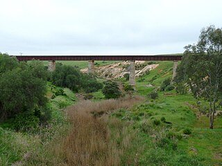
The Hamley Bridge-Gladstone railway line was a railway line on the South Australian Railways network. It extended from a junction at Hamley Bridge on the Roseworthy-Peterborough line through Balaklava and Brinkworth to Gladstone.

The Hundred of Inkerman is a cadastral unit of hundred located on the northern Adelaide Plains in South Australia and bounded on the north by the Wakefield River. It is one of the eight hundreds of the County of Gawler. It was named in 1856 by Governor Richard MacDonnell after the Crimean War Battle of Inkerman.
The Hundred of Balaklava is a cadastral unit of hundred located on the northern Adelaide Plains in South Australia immediately south of the Wakefield River. It is one of the eight hundreds of the County of Gawler. It was named in 1856 by Governor Dominick Daly after the Crimean War Battle of Balaklava. The township of Balaklava is at the extreme north east corner of the hundred.
The District Council of Light was a local government area in South Australia from 1977 to 1996, seated at Freeling.

The Hundred of Dalkey is a cadastral unit of hundred located on the northern Adelaide Plains in South Australia immediately south of the Wakefield River. It is one of the eight hundreds of the County of Gawler. It was named in 1856 by Governor Richard Graves MacDonnell for his hometown Dalkey, a seaside resort in Ireland.

The Hundred of Stow is the cadastral unit of hundred on the northern Adelaide Plains. It is one of the 16 hundreds of the County of Stanley. It was named in 1867 by Governor Dominick Daly after Randolph Isham Stow (1828–1878), twice Attorney-General of South Australia. Parts of the localities of Mount Templeton, Stow, Whitwarta, Watchman and Balaklava are within the hundred.
The District Council of Snowtown was a local government area in South Australia from 1888 to 1987.
The District Council of Hall was a local government area in South Australia from 1878 to 1935.
The District Council of Blyth was a local government area in South Australia from 1872 to 1987 seated at Blyth in the Mid North.

The Hundred of Goyder is the cadastral unit of hundred on the northern Adelaide Plains centred on the locality of Goyder. It is one of the 16 hundreds of the County of Stanley. It was named in 1862 by Governor Dominick Daly after George Goyder, famed South Australian surveyor. In addition to the localities of Goyder and Beaufort, most of Nantawarra lies within the Hundred of Goyder. The portions of Port Wakefield and Bowmans north of the Wakefield River are also inside the hundred, and small parts of the localities of South Hummocks and Mount Templeton cross the western and eastern of boundaries of the hundred, respectively.
The District Council of Port Wakefield was a local government area seated at Port Wakefield in South Australia from 1878 to 1983.
The District Council of Balaklava was a local government area seated at Balaklava in South Australia from 1877 to 1983.
The District Council of Dalkey was a local government area seated at Owen in South Australia from 1875 to 1932.
The Hundred of Alma is a cadastral unit of hundred located on the northern Adelaide Plains of South Australia spanning the township of Alma and the Alma Plains. The hundred was proclaimed in 1856 in the County of Gawler and named by Governor Richard Graves MacDonnell for the River Alma on the Crimean Peninsula, the location of the Battle of the Alma, the first Allied victory in the Crimean War. The hundred is bounded on the north by the Wakefield River and on the south by the Light River
The Plains Producer is a weekly newspaper published Wednesdays by Papers and Publications Pty. Ltd. in Balaklava, South Australia. It was founded in 1903 and was printed until 1941, when it was stopped by the second world war. The publication was revived in 1946 and it has been published continuously since then.
