
Karoonda is in the middle of the Murray Mallee region of South Australia. Karoonda takes its name from the Aboriginal word for "winter camp". The current boundaries include the former town of Lowaldie, which was the next stop on the railway line away from Adelaide.
Karoonda may also refer to:

The District Council of Karoonda East Murray is a local government area in the Murray Mallee area of South Australia. The main council offices are in Karoonda.
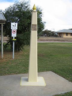
The Karoonda meteorite fell to earth on 25 November 1930 at 10:53 pm near the South Australian town of Karoonda.

Marama is a town and a locality in the Australian state of South Australia located in the state's south-east about 146 kilometres (91 mi) east of the state capital of Adelaide and about 28 kilometres (17 mi) east of the municipal seat of Karoonda.
Nildottie is a locality in the Australian state of South Australia located on the east side of the Murray River about 99 kilometres (62 mi) east of the state capital of Adelaide and about 40 kilometres (25 mi) north-east of the municipal seat in Mannum.
Wynarka is a very small town in South Australia 120 kilometres (75 mi) southeast of Adelaide on the Karoonda Highway (B55) and Loxton railway line in the Murray Mallee. Wynarka lies within the District Council of Karoonda East Murray.

Yumali is a very small country town in South Australia 162 km southeast of Adelaide on the Dukes Highway (A8). Yumali belongs to The Coorong District Council and is in the State electorate of Hammond and the Federal electorate of Barker. Yumali is in the County of Buccleuch.
Borrika is a town and locality in South Australia. It is on the Karoonda Highway 16 kilometres (9.9 mi) east of Karoonda, and was on the Barmera railway line, later known as the Loxton railway line when the end of the main line closed but the Loxton branch remained open until 2015 and has now also closed.
Copeville is a town and a locality in the Australian state of South Australia.
Galga is a settlement in the northern Murray Mallee region of South Australia. The town of Galga was surveyed in 1915 after the Waikerie railway line from Karoonda to Waikerie was opened in 1914. The line was shortened to Galga in 1990, and closed completely in 1994. There is a small bulk grain silo at Galga, but it is no longer regularly used. Galga has an active Country Fire Service brigade with one fire truck.
Sandalwood is a town and locality in the Australian state of South Australia located about 139 kilometres (86 mi) east of the state capital of Adelaide.
The Karoonda Highway is a 172-kilometre-long (107 mi) state-controlled highway in South Australia linking the Murray River towns of Murray Bridge and Loxton. It was created after local councils called for the renaming of the B55 road route.
Bowhill is a locality in South Australia. A settlement is located inside a bend on the left (eastern/southern) bank of the Murray River between Mannum and Swan Reach. It is predominantly shacks built facing the river bank. The settlement is in the Mid Murray Council area, but most of the locality is located away from the river and within in the District Council of Karoonda East Murray, including the Lowan Conservation Park.
Mantung is a town and a locality in the Australian state of South Australia located in the state's south-east about 140 kilometres (87 mi) east of the state capital of Adelaide, and about 58 kilometres (36 mi) north-east and about 48 kilometres (30 mi) south-west respectively of the municipal seats of Karoonda and Loxton.

Burdett is a locality in South Australia located on the eastern side of the Murray River about 3.5 kilometres to the east of the city of Murray Bridge and about 74 kilometres east south-east of the Adelaide city centre. Its name is derived from the Hundred of Burdett.

The County of Albert is one of the 49 cadastral counties of South Australia on the east banks of the River Murray. It was proclaimed by Governor Richard MacDonnell in 1860 and named for Albert, Prince Consort of Queen Victoria.
Bakara is a rural locality in the District Council of Karoonda East Murray of the Murray and Mallee region of South Australia which was established on 11 November 1999.
Mercunda is a town and a locality in the Australian state of South Australia located in the state's south-east about 134 kilometres (83 mi) east of the state capital of Adelaide, and about 52 kilometres (32 mi) north-east and about 53 kilometres (33 mi) south-west respectively of the municipal seats of Karoonda and Loxton.
The District Council of Caurnamont was a local government area in South Australia seated at Walkers Flat on the right bank of the Murray River from 1885 until 1935.
