District Council of Dalkey

Last updated

District Council of Dalkey
South Australia
Australia South Australia location map.svg
Red pog.svg
District Council of Dalkey
Coordinates 34°15′38″S138°30′00″E / 34.26056°S 138.50000°E / -34.26056; 138.50000 Coordinates: 34°15′38″S138°30′00″E / 34.26056°S 138.50000°E / -34.26056; 138.50000
Established1875
Abolished1932
Area280 km2 (108.1 sq mi)
Council seat Owen
LGAs around District Council of Dalkey:
Balaklava Hall Upper Wakefield
Balaklava District Council of Dalkey Rhynie
Alma Plains
Dublin Grace Stockport
Alma Plains

The District Council of Dalkey was a local government area seated at Owen in South Australia from 1875 to 1932.

Local government in the Australian state of South Australia describes the organisations and processes by which towns and districts can manage their own affairs to the extent permitted by section 64A of Constitution Act 1934 (SA).

Owen, South Australia Town in South Australia

Owen is a rural community in the heart of the Adelaide Plains. Owen is 46 metres (150 ft) above sea-level and receives a reliable 416 mm of rain annually and was first settled in about 1865. It is about 80 km north of Adelaide in South Australia and is approximately 40 minutes by road to the nearest main regional centre of Gawler. It is in the Wakefield Regional Council. There was a second railway siding about 4 kilometres (2.5 mi) northwest of the Government Town of Owen named Woods. The small village by this station is now considered to be part of Owen. At the 2011 census, Owen had a population of 272.

South Australia State of Australia

South Australia is a state in the southern central part of Australia. It covers some of the most arid parts of the country. With a total land area of 983,482 square kilometres (379,725 sq mi), it is the fourth-largest of Australia's states and territories by area, and fifth largest by population. It has a total of 1.7 million people, and its population is the second most highly centralised in Australia, after Western Australia, with more than 77 percent of South Australians living in the capital, Adelaide, or its environs. Other population centres in the state are relatively small; Mount Gambier, the second largest centre, has a population of 28,684.

Contents

History

The District Council of Dalkey was officially proclaimed as incorporating the entire Hundred of Dalkey on 25 March 1875. [1] The five inaugural councillors appointed on the date of the proclamation were John Fisher, Edward George Gibbs, Isaiah Hill, Richard Keane Spotswood, and Gottlieb Trager. [1]

Hundred of Dalkey Cadastral in South Australia

The Hundred of Dalkey is a cadastral unit of hundred located on the northern Adelaide Plains in South Australia immediately south of the Wakefield River. It is one of the eight hundreds of the County of Gawler. It was named in 1856 by Governor Richard Graves MacDonnell for his hometown Dalkey, a seaside resort in Ireland.

In 1882 a council chamber was opened for the Dalkey council in Owen. [2]

The Dalkey council ceased to exist in 1932 when it was amalgamated with the District Council of Alma Plains to form the new District Council of Owen, [2] but the new council seat was kept at Owen.

Neighbouring local government

The following adjacent local government bodies co-existed with the Dalkey council:

District Council of Hall Local government area in South Australia

The District Council of Hall was a local government area in South Australia from 1878 to 1935.

Wakefield River river in South Australia, Australia

The Wakefield River is an ephemeral river that flows to an estuary in the Australian state of South Australia.

District Council of Upper Wakefield Local government area in South Australia

The District Council of Upper Wakefield was a local government area in South Australia centred on the town of Auburn from 1854 until 1970.

Related Research Articles

Wakefield Regional Council Local government area in South Australia

Wakefield Regional Council is a local government area in the Yorke and Mid North region of South Australia. The council seat is at Balaklava.

District Council of Wakefield Plains Local government area in South Australia

The District Council of Wakefield Plains was a local government area in South Australia from 1983 to 1997, seated at Balaklava.

Balaklava, South Australia Town in South Australia

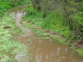
The town of Balaklava is located in South Australia, 92 kilometres north of Adelaide in the Mid North region. It is on the south bank of the Wakefield River, 25 kilometres east of Port Wakefield.

Wooroora was an electoral district of the House of Assembly in the Australian colony of South Australia.

Hundred of Inkerman Cadastral in South Australia

The Hundred of Inkerman is a cadastral unit of hundred located on the northern Adelaide Plains in South Australia and bounded on the north by the Wakefield River. It is one of the eight hundreds of the County of Gawler. It was named in 1856 by Governor Richard MacDonnell after the Crimean War Battle of Inkerman.

Hundred of Balaklava Cadastral in South Australia

The Hundred of Balaklava is a cadastral unit of hundred located on the northern Adelaide Plains in South Australia immediately south of the Wakefield River. It is one of the eight hundreds of the County of Gawler. It was named in 1856 by Governor Dominick Daly after the Crimean War Battle of Balaklava. The township of Balaklava is at the extreme north east corner of the hundred.

Dalkey, South Australia Town in South Australia

Dalkey is a locality in the Mid North of South Australia. It was established as a private subdivision of section 171 in the Hundred of Dalkey on the main road from Adelaide to Balaklava. It is named for the Hundred of Dalkey which in turn was named after Dalkey in Ireland. The boundaries of the locality were defined in 2000 for the long-established name.

Hundred of Stow Cadastral in South Australia

The Hundred of Stow is the cadastral unit of hundred on the northern Adelaide Plains. It is one of the 16 hundreds of the County of Stanley. It was named in 1867 by Governor Dominick Daly after Randolph Isham Stow (1828–1878), twice Attorney-General of South Australia. Parts of the localities of Mount Templeton, Stow, Whitwarta, Watchman and Balaklava are within the hundred.

District Council of Snowtown Local government area in South Australia

The District Council of Snowtown was a local government area in South Australia from 1888 to 1987.

Hundred of Hall Cadastral in South Australia

The Hundred of Hall is the cadastral unit of hundred on the northern Adelaide Plains centred on the town of Halbury. It is one of the 16 hundreds of the County of Stanley. It was named in 1860 after parliamentarian George Hall (1851-1867). The main localities in the hundred are Halbury and Hoyleton with parts of Balaklava, Stow, Watchman and Kybunga also within the hundred bounds.

District Council of Blyth Local government area in South Australia

The District Council of Blyth was a local government area in South Australia from 1872 to 1987 seated at Blyth in the Mid North.

Hundred of Goyder Cadastral in South Australia

The Hundred of Goyder is the cadastral unit of hundred on the northern Adelaide Plains centred on the locality of Goyder. It is one of the 16 hundreds of the County of Stanley. It was named in 1862 by Governor Dominick Daly after George Goyder, famed South Australian surveyor. In addition to the localities of Goyder and Beaufort, most of Nantawarra lies within the Hundred of Goyder. The portions of Port Wakefield and Bowmans north of the Wakefield River are also inside the hundred, and small parts of the localities of South Hummocks and Mount Templeton cross the western and eastern of boundaries of the hundred, respectively.

District Council of Port Wakefield Local government area in South Australia

The District Council of Port Wakefield was a local government area seated at Port Wakefield in South Australia from 1878 to 1983.

District Council of Balaklava Local government area in South Australia

The District Council of Balaklava was a local government area seated at Balaklava in South Australia from 1877 to 1983.

District Council of Hindmarsh Local government area in South Australia

The District Council of Hindmarsh was a local government area in South Australia from 1853 to 1875, seated at the inner north west Adelaide suburb of Hindmarsh.

City of Woodville Local government area in South Australia

The City of Woodville was a local government area in South Australia from 1875 to 1993, seated at the inner north west Adelaide suburb of Woodville.

Hundred of Alma Cadastral in South Australia

The Hundred of Alma is a cadastral unit of hundred located on the northern Adelaide Plains of South Australia spanning the township of Alma and the Alma Plains. The hundred was proclaimed in 1856 in the County of Gawler and named by Governor Richard Graves MacDonnell for the River Alma on the Crimean Peninsula, the location of the Battle of the Alma, the first Allied victory in the Crimean War. The hundred is bounded on the north by the Wakefield River and on the south by the Light River

References

  1. 1 2 "Proclamations—District of Dalkey" (PDF). South Australian Government Gazette (13 ed.). Government of South Australia. 1875: 551. 25 March 1875. Retrieved 5 July 2017. [...] Messrs. John Fisher, Edward George Gibbs, Isaiah Hill, Richard Keane Spotswood, and Gottlieb Trager shall be the first District Councillors for the District of Dalkey aforesaid.
  2. 1 2 Marsden, Susan (2012). "LOCAL GOVERNMENT ASSOCIATION OF SOUTH AUSTRALIA: A HISTORY OF SOUTH AUSTRALIAN COUNCILS to 1936" (PDF). Proclaimed on 25 March 1875. The first councillors were R Spotswood (Chairman), Traeger, J Fisher, G Gibbs and Mr Hill. J Spotswood was requested to take the clerkship until after elections in July. A Council Chamber was built in 1882. On 12 May 1932 Dalkey was united with DC of Alma Plains to form the new DC of Owen.