
Redruth is a town and civil parish in Cornwall, England, United Kingdom. The population of Redruth was 14,018 at the 2011 census. In the same year the population of the Camborne-Redruth urban area, which also includes Carn Brea, Illogan and several satellite villages, stood at 55,400 making it the largest conurbation in Cornwall. Redruth lies approximately at the junction of the A393 and A3047 roads, on the route of the old London to Land's End trunk road, and is approximately 9 miles (14 km) west of Truro, 12 miles (19 km) east of St Ives, 18 miles (29 km) north east of Penzance and 11 miles (18 km) north west of Falmouth. Camborne and Redruth together form the largest urban area in Cornwall and before local government reorganisation were an urban district.

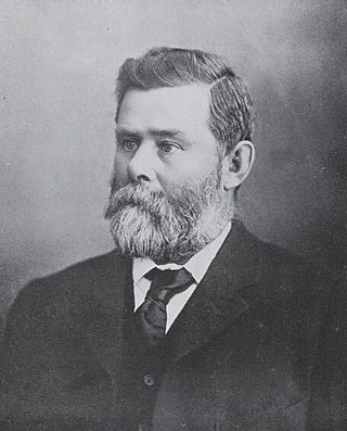
Charles Hervey Bagot, often referred to as "Captain Bagot", was a South Australian pastoralist, mine owner and parliamentarian, and was the ancestor of a number of notable South Australian citizens.

Richard Ernest Nowell Twopeny was an Australian rules footballer, frequently spelled Twopenny or Tuppenny; also journalist and newspaper editor/owner in New Zealand and Australia, in which context he was invariably referred to as R. E. N. Twopeny.
John Lewis was an Australian pastoralist and politician. He was a member of the South Australian Legislative Council from 1898 to 1923, representing the Northern District (1898-1902) and North-Eastern District (1902-1923). He was the father of Essington Lewis.
The District Council of Georgetown was a local government area in South Australia, centred on the town of Georgetown.
The District Council of Laura was a local government area in South Australia. It was created on 1 May 1932 with the amalgamation of the Corporate Town of Laura and the District Council of Booyoolie. It reunited the whole cadastral Hundred of Booyoolie within the same district council, as had previously been the case when the Booyoolie council was first proclaimed in 1876. The Laura merger had occurred after a much broader 1931 merger proposal, which would have seen the Corporate Town of Laura, District Council of Gladstone, Corporate Town of Gladstone and District Council of Caltowie merge into a drastically enlarged District Council of Booyoolie, was abandoned after meeting strong opposition from both the Laura and Gladstone communities.
The District Council of Gladstone was a local government area in South Australia. It was proclaimed on 10 August 1876 as the District Council of Yangya, named for the cadastral Hundred of Yangya, but was renamed Gladstone after its main town on 14 August 1879. Gladstone had been built as a private township very close to the hundred boundary, and the adjacent government township of Booyoolie, built not long after, was in the adjacent Hundred of Booyoolie, and formed as the separate District Council of Booyoolie, dividing the twin towns into two separate municipalities based on their respective hundreds. It gained the Booyoolie township from that council in 1879, and acquired the remainder of what had been the southern portion of the Booyoolie council on 12 August 1880. It then gained the remainder of the Hundred of Yangya under the District Councils Act 1887.
The City of Port Pirie was a local government area in South Australia from 1876 to 1997, centred on the city of Port Pirie.

The District Council of Burra Burra was a local government area in South Australia from 1935 to 1997.

The District Council of Eudunda was a local government area in South Australia from 1932 to 1997. The central town and council seat was Eudunda. It was established on 12 May 1932 with the amalgamation of the District Council of Julia and the District Council of Neales. By 1936, it was divided up into four wards: Brownlow, Eudunda and Neales and Julia. It met at the District Hall at Eudunda, which had formerly been owned by the Neales council, until 1963. The council existed until 1997, when it amalgamated with the District Council of Burra Burra, the District Council of Hallett and the District Council of Robertstown to form the Regional Council of Goyder.
The District Council of Hallett was a local government area in South Australia from 1877 to 1997.
The Corporate Town of Moonta was a local government area in South Australia from 1872 to 1984, centred on the town of Moonta.
The District Council of Apoinga was a local government area in South Australia from 1873 to 1932.
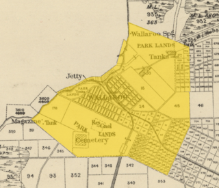
The Corporate Town of Wallaroo was a local government area in South Australia from 1874 to 1997, centred on the town of Wallaroo.
The District Council of Booborowie was a local government area in South Australia from 1875 to 1935.
The District Council of English was a local government area in South Australia from 1878 to 1932.
The District Council of Hanson was a local government area in South Australia from 1878 to 1935.
The District Council of Burra was a local government area in South Australia from 1872 to 1935.

The City of Kensington and Norwood, originally the Corporate Town of Kensington and Norwood, was a local government area in South Australia from 1853 to 1997, centred on the inner eastern Adelaide suburbs of Kensington and Norwood. In November 1997 it amalgamated with the City of Payneham and the Town of St Peters to form the City of Norwood Payneham & St Peters.
The Corporate Town of St Peters was a local government area in South Australia from 1883 to 1997.
