
The Clare and Gilbert Valleys Council is a local government area located in the Yorke and Mid North region of South Australia. The council was founded on 1 July 1997 with the amalgamation of the District Council of Clare, the District Council of Riverton and the District Council of Saddleworth and Auburn. The council seat is located at Clare; it also maintains branch offices at Riverton and Saddleworth.

Hamley Bridge is a community in South Australia located at the junction of the Gilbert and Light rivers, as well as the site of a former railway junction.
Wooroora was an electoral district of the House of Assembly in the Australian colony of South Australia.

The Hundred of Belvidere is a cadastral unit of hundred located in the north Barossa Valley of South Australia in the County of Light.

Andrews is a rural locality in the Northern Areas Council of South Australia, located on the Hill River. Its boundaries were formalised in April 2001 for the long established name for the area. The district, which is primarily dedicated to primary production, mainly grain farming, is in the Spalding Ward of the council. The township has bulk grain handling and storage facilities as well as limited sporting and community facilities. The Hill River Road and the Hill River run north-south through the locality, while Andrews Road runs east-west, connecting the Goyder Highway with RM Williams Way. In the 2011 census, the population of Andrews was too low to separately report; it was included in that of adjacent Spalding.
Alma is a small town in South Australia halfway between the Wakefield River, to the north, and River Light to the south. Alma, Alma South and Alma Plains were named for the cadastral Hundred of Alma in which they lie, which was in turn named after the Battle of the Alma, the site of an allied victory in the Crimean War.

The County of Light is one of the 49 cadastral counties of South Australia. It was proclaimed by Governor George Grey in 1842 and named for the River Light, the river being named after Colonel William Light, the first Surveyor-General of South Australia. It covers the modern region of the Barossa Valley and a portion of the northern Mt Lofty Ranges. It is bounded by the upper Wakefield River in the north, the approximate path of Horrocks Highway in the west, and the North Para River in the south, and is bisected east to west by the River Light.
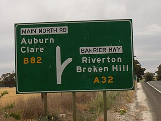
The Hundred of Gilbert is a cadastral unit of hundred in the northern Mount Lofty Ranges including the town of Riverton. It is one of the nine hundreds of the County of Light. It was proclaimed in 1851 by Governor Henry Young and named after the Gilbert River, which flows from north to south through the hundred. The river, in turn, was named in honour of South Australian pioneer Thomas Gilbert.
The District Council of Hall was a local government area in South Australia from 1878 to 1935.
The District Council of Port Wakefield was a local government area seated at Port Wakefield in South Australia from 1878 to 1983.
The District Council of Balaklava was a local government area seated at Balaklava in South Australia from 1877 to 1983.
The District Council of Dalkey was a local government area seated at Owen in South Australia from 1875 to 1932.
The Local Government Areas (Re-arrangement) Acts 1929 and 1931 were acts of the Parliament of South Australia. The application of the acts, via recommendations of the commission of the same name, led to the statewide re-arrangement of local government areas, effected from 1932 to 1935.
The District Council of Munno Mara West was a local government area of South Australia on the central Adelaide Plains from 1854 to 1933.
The District Council of Light was a local government area in South Australia from 1867 to 1892.
The Hundred of Alma is a cadastral unit of hundred located on the northern Adelaide Plains of South Australia spanning the township of Alma and the Alma Plains. The hundred was proclaimed in 1856 in the County of Gawler and named by Governor Richard Graves MacDonnell for the River Alma on the Crimean Peninsula, the location of the Battle of the Alma, the first Allied victory in the Crimean War. The hundred is bounded on the north by the Wakefield River and on the south by the Light River

The Corporation and District Council of Clare were twin local government areas in South Australia centred on the town of Clare. The district council existed from 1853 until 1997, while the town corporation existed from 1868 until 1969.
The District Council of Kapunda was a local government area in South Australia from 1866 to 1996. The Kapunda town corporation was formed a year earlier in 1865 and ultimately amalgamated into the district council.
The District Council of Gilbert was a local government area seated at Riverton in South Australia from 1866 to 1932.
The District Council of Alma Plains was a local government area in South Australia seated at Alma from 1870 to 1932.
