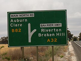
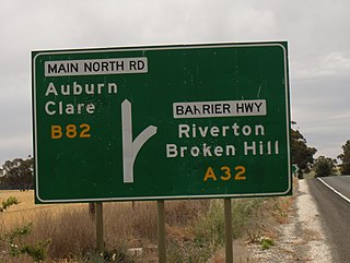
Barrier Highway is a highway in South Australia and New South Wales, and is designated part of route A32. The name of the highway is derived from the Barrier Ranges, an area of moderately high ground in the far west of New South Wales, through which the highway traverses.

Main North Road is the major north-south arterial route through the suburbs north of the Adelaide City Centre in the city of Adelaide, South Australia. It continues north through the settled areas of South Australia and is a total of 307 kilometres (191 mi) long, from North Adelaide to 21 kilometres (13 mi) out of Port Augusta. It follows the route established in the early years of the colony by explorer John Horrocks and was a major route for farmers and graziers to reach the capital, passing through rich farmland and the Clare Valley wine region. In 2011, the section of road between Gawler to Wilmington was renamed Horrocks Highway.
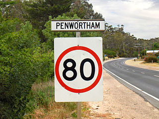
Penwortham is a small town in the Clare Valley, South Australia, along the Horrocks Highway, approximately 10 kilometres south of Clare and 14 kilometres north of Auburn.

Auburn is a small town in the southern edge of the Clare Valley, in the Mid North of South Australia.

Tarlee is a town in South Australia. The origin of the name is uncertain, but it is thought to be a corruption of the name Tralee in Ireland. The township of Tarlee was advertised as readied for sale by auction in 1867. Tarlee is in the lower Mid North region where Horrocks Highway crosses the Gilbert River. It is approximately 8 km south of Giles Corner, where the Barrier Highway to Broken Hill diverges from the Horrocks Highway through the Clare Valley. At the 2016 census, Tarlee had a population of 302.

Goodwood Road is a major north–south arterial road, approximately 10 kilometres long, in Adelaide, South Australia. It runs between the Adelaide city centre and Adelaide's southern suburbs of Pasadena and Panorama
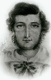
John Ainsworth Horrocks was an English pastoralist and explorer who was one of the first European settlers in the Clare Valley of South Australia where, in 1840, he established the village of Penwortham.

Vista is a small north-eastern suburb of Adelaide, South Australia and is within the City of Tea Tree Gully local government area. It is adjacent to Houghton, Tea Tree Gully, St Agnes and Hope Valley.
Adelaide–Mannum Road is a road that runs through the northern Adelaide Hills between the South Australian capital, Adelaide and Mannum on the Murray River. It is designated route A10 in the metropolitan area and B10 in rural areas, and is 79 kilometres in length. This name covers many consecutive streets and is not widely known to most drivers, as the entire allocation is still best known as by the names of its constituent parts: Northcote Terrace, North East Road, Torrens Valley Road, Randell Road and Adelaide Road. This article will deal with the entire length of the corridor for sake of completion, as well to avoid confusion between declarations.

Tom Giles was a business associate of George Anstey and developed pastoral leases on Eyre and Yorke Peninsulas during the 19th century.

Anstey Hill Recreation Park is a 362-hectare (890-acre) protected area established in 1989 and located approximately 19 kilometres (12 mi) northeast of Adelaide, South Australia. The park is a significant reserve of bushland in the foothills of the Mount Lofty Ranges and is home to rare or vulnerable native plants and animals, and problematic invasive species. It is managed by the City of Tea Tree Gully, the Department of Environment, Water and Natural Resources and a volunteer group—The Friends of Anstey Hill. The park is designed for recreational walking and has no visitor facilities. It is managed in association with the regional planning initiative known as of Yurrebilla, the Greater Mount Lofty Parklands.

Undalya is a small rural town on the southern edge of the Clare Valley, in the mid north of the state of South Australia. It is located on the Horrocks Highway approximately halfway between the towns of Auburn and Rhynie, at the junction of the River Wakefield and Pine Creek. To the east lies the town of Saddleworth and to the south-west lies the town of Balaklava. The town was officially gazetted as Undalya in 1859.
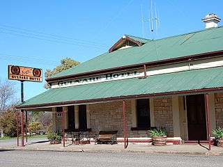
Gulnare is a settlement in South Australia. At the 2006 census, Gulnare had a population of 95. It is where the east–west Goyder Highway crosses the former Gladstone-Balaklava railway, and about a kilometre east of the south–north Horrocks Highway, 188 kilometres (117 mi) north of Adelaide. The railway was built as narrow gauge in 1894 and converted to broad gauge in 1927. The railway had been closed by 1993.
The Parade, often referred to as Norwood Parade, is a major arterial road in the South Australian capital of Adelaide, connecting its inner eastern suburbs to the western foot of the Mount Lofty Ranges.

Woolshed Flat is a locality near the southern end of the Clare Valley in South Australia. It is located in the District Council of Clare and Gilbert Valleys.

Mount Davies Road is a remote unsealed outback track which runs from Mount Davies (Pipalyatjara) in the far north-west corner of South Australia to Anne's Corner on the Anne Beadell Highway 397 kilometres to the south-east. It was built during 1956 and 1957 by the Gunbarrel Road Construction Party (GRCP) surveyed and led by Len Beadell for the Weapons Research Establishment at Woomera, South Australia.
Thiele Highway is a road in South Australia connecting the outskirts of Adelaide to the North west bend of the Murray River at Morgan, South Australia. It is named after author Colin Thiele who lived most of his life in towns along the route, and set some of his stories in the area.
Solomontown is a suburb of Port Pirie in South Australia. It was historically a separate town. It was named after Emanuel Solomon, who owned the land that the town developed on.
Redbanks is a town and locality in South Australia's lower Mid North. The boundaries were formally established in June 1997 for "the long established name".
The Hundred of Gilbert is a cadastral unit of hundred in the northern Mount Lofty Ranges including the town of Riverton. It is one of the nine hundreds of the County of Light. It was proclaimed in 1851 by Governor Henry Young and named after the Gilbert River, which flows from north to south through the hundred. The river, in turn, was named in honour of South Australian pioneer Thomas Gilbert.