Halbury, South Australia

Last updated

Halbury
South Australia
Halbury entrance sign.JPG
Western entry sign, Halbury
Australia South Australia location map.svg
Red pog.svg
Halbury
Coordinates 34°05′0″S138°31′0″E / 34.08333°S 138.51667°E / -34.08333; 138.51667 Coordinates: 34°05′0″S138°31′0″E / 34.08333°S 138.51667°E / -34.08333; 138.51667
Population363 (2006 census) [1]
Postcode(s) 5461
Location
LGA(s)
Region Mid North
State electorate(s) Goyder
Federal division(s) Grey
Localities around Halbury:
Stow Hoyleton Auburn
Watchman Halbury Woolshed Flat
Balaklava Owen Salter Springs

Halbury is a former railway town in South Australia, west of the Clare Valley, halfway between Balaklava and Auburn. At the 2006 census, Halbury had a population of 363. [1]

Contents

Etymology

Halbury is situated in the Hundred of Hall, named after politician George Hall. [2]

Railway

Halbury was a stop on the Port Wakefield railway line, an isolated narrow gauge horse-drawn railway [3] connecting to the port at Port Wakefield from Balaklava and Hoyleton. Halbury was where this railway crossed the Gulf Road from Auburn and Burra to the port. [4]

The Gladstone railway line ran from Hamley Bridge through Balaklava to Blyth and further on into the Mid North of the state. The line was originally narrow gauge 1,067 mm (3 ft 6 in), but was converted to broad gauge 1,600 mm (5 ft 3 in) in 1927. [5] Due to various reasons, this particular line became obsolete and the tracks were dismantled in the late 1980s. After Halbury, the railway line veered to the north-east, travelling on to the towns of Hoyleton, Kybunga and further north to Blyth. [6]

The railway siding at Halbury was opened in 1870 and closed to all goods and parcels traffic in 1981. [7] Station brand: "HY". Station code number 1274. Railway distance from Adelaide: 74 miles, 1 chain. [8]

Shamus Liptrot Cycling Trail

The former Halbury to Balaklava railway line was re-opened as a 12 km low-gradient cycling trail in 2016, named after elite junior local cyclist Shamus Liptrot who died in 2011, several years after suffering serious injuries in a cycling accident. The trail extends from Balaklava to Halbury, Shamus's home town. [9] The trail is the central link of the 26 km Copper Trail, which extends from Leasingham in the Clare Valley, to Port Wakefield at the head of the Gulf St Vincent. [10]

Railway Signboard Project

In 2022, to commemorate the railway history of the area, a group of Christian railway enthusiasts reinstalled an exact replica of the original Halbury railway station sign.

The text on the plaque affixed to the sign reads: "This is the site of the Halbury railway siding, 74 Miles, 1 Chain. 1870 – 1981. Sign made and reinstalled Easter 2022 by J. Leigh and E. Green, Railway Infrastructure Services. This sign would not be here if not for Lorraine Zaharuiko, 1984-2021. John 3:16-21." [11]

Government

The township of Halbury in the west of the locality is in the Wakefield Regional Council local government area. The hillier east of the locality is part of the District Council of Clare and Gilbert Valleys.

Related Research Articles

Railways in Adelaide Regional rail network

The rail network in Adelaide, South Australia, consists of four lines and 89 stations, totalling 132 km. It is operated by Keolis Downer under contract from the Government of South Australia, and is part of the citywide Adelaide Metro public transport system.

Wakefield Regional Council Local government area in South Australia

Wakefield Regional Council is a local government area in the Yorke and Mid North region of South Australia. The council seat is at Balaklava.

Rail transport in South Australia

The first railway in colonial South Australia was a line from the port of Goolwa on the River Murray to an ocean harbour at Port Elliot, which first operated in December 1853, before its completion in May 1854.

Division of Wakefield Former Australian federal electoral division

The Division of Wakefield was an Australian electoral division in the state of South Australia. The seat was a hybrid rural-urban electorate that stretched from Salisbury in the outer northern suburbs of Adelaide at the south of the seat right through to the Clare Valley at the north of the seat, 135 km from Adelaide. It included the suburbs of Elizabeth, Craigmore, Munno Para, and part of Salisbury, and the towns of Balaklava, Clare, Freeling, Gawler, Kapunda, Mallala, Riverton, Tarlee, Virginia, Williamstown, and part of Port Wakefield.

Owen, South Australia Town in South Australia

Owen is a rural community in the heart of the Adelaide Plains. Owen is 46 metres (150 ft) above sea-level and receives a reliable 416 mm of rain annually and was first settled in about 1865. It is about 80 km north of Adelaide in South Australia and is approximately 40 minutes by road to the nearest main regional centre of Gawler. It is in the Wakefield Regional Council.

Port Wakefield, South Australia Town in South Australia

Port Wakefield is a town at the mouth of the River Wakefield, at the head of the Gulf St Vincent in South Australia. It was the first government town to be established north of the state capital, Adelaide. Port Wakefield is situated 98.7 kilometres from the Adelaide city centre on the Port Wakefield Highway section of the A1 National Highway.

Hoyleton, South Australia Town in South Australia

Hoyleton is a former railway town in South Australia, west of the Clare Valley, halfway between Leasingham and Halbury. At the 2006 census, Hoyleton had a population of 283.

Balaklava, South Australia Town in South Australia

The town of Balaklava is located in South Australia, 92 kilometres north of Adelaide in the Mid North region. It is on the south bank of the Wakefield River, 25 kilometres east of Port Wakefield.

Clare, South Australia Town in South Australia

The town of Clare is located in South Australia in the Mid North region, 136 km north of Adelaide. It gives its name to the Clare Valley wine and tourist region.

Blyth, South Australia Town in South Australia

Blyth is a small town in the Mid North of South Australia, located 13 kilometres (8.1 mi) west of the renowned Clare Valley. The town is located on the lands of the Kaurna people, the indigenous people who lived there before European settlement. It has a population of 306, the farming community spanning the plains between the Clare Hills and the Barunga/Hummocks ranges. Altitude is 189 metres (620 ft), and rainfall is approximately 400 millimetres (16 in) per annum.

Bowmans is a locality in South Australia's Mid North. At the 2006 census, Bowmans had a population of 203. It is named after R and C Bowman who were "pastoralists in area."

Hamley Bridge, South Australia Town in South Australia

Hamley Bridge is a community in South Australia located at the junction of the Gilbert and Light rivers, as well as the site of a former railway junction.

Wooroora was an electoral district of the House of Assembly in the Australian colony of South Australia.

Hamley Bridge-Gladstone railway line Former railway line in South Australia

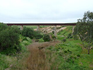
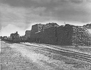
The Hamley Bridge-Gladstone railway line was a railway line on the South Australian Railways network. It extended from a junction at Hamley Bridge on the Roseworthy-Peterborough line through Balaklava and Brinkworth to Gladstone.

Kybunga, South Australia Town in South Australia

Kybunga is a locality in the Mid North of South Australia. It was on the Gladstone railway line 87+12 miles (140.8 km) north of Adelaide on the plains to the west of the Clare Valley. Kybunga school opened in 1881 and closed in 1988. The former Methodist and Uniting church opened in 1886 and is now a private residence.

Balaklava-Moonta railway line

The Balaklava-Moonta railway line was a railway line on the South Australian Railways network. It ran across the top of the Yorke Peninsula.

The District Council of Hall was a local government area in South Australia from 1878 to 1935.

The Hundred of Hall is the cadastral unit of hundred on the northern Adelaide Plains centred on the town of Halbury. It is one of the 16 hundreds of the County of Stanley. It was named in 1860 after parliamentarian George Hall (1851-1867). The main localities in the hundred are Halbury and Hoyleton with parts of Balaklava, Stow, Watchman and Kybunga also within the hundred bounds.

The District Council of Blyth was a local government area in South Australia from 1872 to 1987 seated at Blyth in the Mid North.

References

  1. 1 2 Australian Bureau of Statistics (25 October 2007). "Halbury (State Suburb)". 2006 Census QuickStats. Retrieved 30 July 2011.
  2. "Place Names of South Australia – H". The Manning Index of South Australian History. Government of South Australia.
  3. "PORT WAKEFIELD RAILWAY". The South Australian Advertiser . Adelaide, SA: National Library of Australia. 21 August 1869. p. 2. Retrieved 2 December 2015.
  4. "PORT WAKEFIELD RAILWAY". The South Australian Advertiser . Adelaide, SA: National Library of Australia. 10 August 1871. p. 2. Retrieved 2 December 2015.
  5. ""THE BIG PUSH."". The Register (Adelaide, SA : 1901 – 1929) . Adelaide, SA: National Library of Australia. 1 August 1927. p. 9. Retrieved 2 December 2015.
  6. Horse and Steam, Wheat and Copper Callaghan, W.H. Australian Railway Historical Society Bulletin, January;February, 2002 pp9-27;46-63
  7. "Stations Remembered: SAR – Halbury, Hoyleton & Kybunga by Steve McNicol – Paperback – 1st Edition 1st Printing – 2021 – from Train World Pty Ltd (SKU: ARMP-0223)". Biblio.com.au. Retrieved 5 April 2022.
  8. "Stations Remembered: SAR – Halbury, Hoyleton & Kybunga by Steve McNicol – Paperback – 1st Edition 1st Printing – 2021 – from Train World Pty Ltd (SKU: ARMP-0223)". Biblio.com.au. Retrieved 5 April 2022.
  9. "Shamus Liptrot Cycling Trail – Clare Valley Tourism". clarevalley.com.au. Retrieved 20 April 2022.
  10. "Shamus Liptrot Cycling Trail, Balaklava to Halbury". Walking SA. Retrieved 20 April 2022.
  11. Halbury Railway sign plaque 18Apr2022.jpg

Commons-logo.svg Media related to Halbury, South Australia at Wikimedia Commons