Saddleworth, South Australia

Last updated

Saddleworth
South Australia
SaddleworthBelvidereRoad.JPG
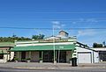
Belvidere Road, the main street of Saddleworth

Shops in Saddleworth(GN00943).jpg

Bee & Hill store, 1894-1919
Australia South Australia location map.svg
Red pog.svg
Saddleworth
Coordinates 34°05′0″S138°47′0″E / 34.08333°S 138.78333°E / -34.08333; 138.78333 Coordinates: 34°05′0″S138°47′0″E / 34.08333°S 138.78333°E / -34.08333; 138.78333
Population483 (SAL 2021) [1]
Postcode(s) 5413
Location
  • 103 km (64 mi) north of Adelaide
  • 53 km (33 mi) south of Burra
  • 12 km (7 mi) south-east of Auburn
LGA(s) District Council of Clare and Gilbert Valleys
State electorate(s) Frome
Federal division(s) Grey

Saddleworth is a small town in the Mid North region of South Australia. The town is situated on the Gilbert River and along with neighbouring towns of Riverton, Rhynie and Tarlee the local area is known as the Gilbert Valley. The town is bisected by the Barrier Highway. At the 2016 census, Saddleworth had a population of 470. [2]

Saddleworth was originally established as one of many settlements on the road to Burra, and was named after Saddleworth Lodge pastoral station, a local landholding which itself was named after a civil parish on the edges of the Pennines in Yorkshire, England, part of which is in the Metropolitan Borough of Oldham near Greater Manchester, England. [3] Joseph Dunn applied for a Publican's Licence to open a new Saddleworth Lodge in March 1846, and it was granted on 14 March 1846. [4] The Burra railway line passed through the town from 1870 [5] until the early 2000s.

An old store on the Barrier Highway has been converted into a museum which focuses on the history of Saddleworth and the nearby towns of Waterloo, Marrabel, and Manoora.

Saddleworth is in the District Council of Clare and Gilbert Valleys local government area, the state electoral district of Frome and the federal Division of Grey.

The town has a 3 km long Heritage Walking Trail which provides an insight into the history of the area. . [6]

In May 2016 the local store burned down. The store was also home to the town's Post Office.

Related Research Articles

<span class="mw-page-title-main">Burra, South Australia</span> Town in South Australia

Burra is a pastoral centre and historic tourist town in the mid-north of South Australia. It lies east of the Clare Valley in the Bald Hills range, part of the northern Mount Lofty Ranges, and on Burra Creek. The town began as a single company mining township that, by 1851, was a set of townships collectively known as "The Burra". The Burra mines supplied 89% of South Australia's and 5% of the world's copper for 15 years, and the settlement has been credited with saving the economy of the struggling new colony of South Australia. The Burra Burra Copper Mine was established in 1848 mining the copper deposit discovered in 1845. Miners and townspeople migrated to Burra primarily from Cornwall, Wales, Scotland and Germany. The mine first closed in 1877, briefly opened again early in the 20th century and for a last time from 1970 to 1981.

<span class="mw-page-title-main">Riverton, South Australia</span> Town in South Australia

Riverton is a small town in the Mid North of South Australia, in the Gilbert Valley. It is situated on the Gilbert River, from which the town derives its name. Both the Gilbert Valley and Gilbert River were named after the South Australian pioneer Thomas Gilbert. Riverton was first settled in 1856, as a settlement along the bullock track from the mining town of Burra to the capital city Adelaide. It grew from a plan designed by a James Masters who had established the nearby town of Saddleworth. The streets of Riverton received their names chiefly from James Masters and his friends. They commemorate persons notable in the history of the district or the state. At the 2011 census, Riverton had a population of 810. Including the rural areas surrounding the town, the population was 1213.

<span class="mw-page-title-main">Watervale, South Australia</span> Town in South Australia

Watervale is a town on the Horrocks Highway in the Clare Valley, South Australia, approximately 9 kilometres north of Auburn and 15 kilometres south of Clare. It is surrounded by a number of small wineries and several B&Bs. The Riesling Trail runs past the town to the west, between the Highway and the Skilly Hills. The town has a number of 19th-century heritage buildings, including the former Stanley Grammar School, which now provides private bed and breakfast accommodation.

<span class="mw-page-title-main">Penwortham, South Australia</span> Town in South Australia

Penwortham is a small town in the Clare Valley, South Australia, along the Horrocks Highway, approximately 10 kilometres south of Clare and 14 kilometres north of Auburn.

<span class="mw-page-title-main">Auburn, South Australia</span> Town in South Australia

Auburn is a small town in the southern edge of the Clare Valley, in the Mid North of South Australia.

<span class="mw-page-title-main">Tarlee, South Australia</span> Town in South Australia

Tarlee is a town in South Australia. The origin of the name is uncertain, but it is thought to be a corruption of the name Tralee in Ireland. The township of Tarlee was advertised as readied for sale by auction in 1867. Tarlee is in the lower Mid North region where Horrocks Highway crosses the Gilbert River. It is approximately 8 km south of Giles Corner, where the Barrier Highway to Broken Hill diverges from the Horrocks Highway through the Clare Valley. At the 2016 census, Tarlee had a population of 302.

<span class="mw-page-title-main">Eudunda</span> Town in South Australia

Eudunda is a rural town in South Australia, roughly 103 kilometres northeast of Adelaide, established in 1870 after settlers began moving into the area in the 1860s. As of the 2006 census, Eudunda had a population of 640.

<span class="mw-page-title-main">Clare and Gilbert Valleys Council</span> Local government area in South Australia

The Clare and Gilbert Valleys Council is a local government area located in the Yorke and Mid North region of South Australia. The council was founded on 1 July 1997 with the amalgamation of the District Council of Clare, the District Council of Riverton and the District Council of Saddleworth and Auburn. The council seat is located at Clare; it also maintains branch offices at Riverton and Saddleworth.

<span class="mw-page-title-main">Mintaro, South Australia</span> Town in South Australia

Mintaro is a historic town in the eastern Clare Valley, east of the Horrocks Highway, about 126 kilometres north of Adelaide, South Australia. The town lies at the south-eastern corner of the Hundred of Clare, within the Clare Valley wine region. Established in 1849, Mintaro is situated on land which was bought originally by Joseph and Henry Gilbert, which they sub-divided into 80 allotments.

<span class="mw-page-title-main">Giles Corner, South Australia</span> Place in South Australia

Giles Corner is the name of the intersection of Main North Road and the Barrier Highway, halfway between the towns of Tarlee and Rhynie. The Barrier Highway branches off from Horrocks Highway at this location, heading north towards Riverton, Burra and eventually Broken Hill. Horrocks Highway continues in a northerly direction, on to the towns of Rhynie, Auburn and Clare. There is also an unsealed back road starting just north of the junction which heads west and ends at the road between Balaklava and Owen, approximately 20 kilometres away. Although not a town, Giles Corner is sign posted to mark its location.

<span class="mw-page-title-main">Mount Torrens, South Australia</span> Town in South Australia

Mount Torrens is a town in the eastern Adelaide Hills region of South Australia, 46 kilometres east-north-east of the state capital, Adelaide and 8 km east of Lobethal. It is located in the Adelaide Hills Council and the Mid Murray Council local government areas. At the 2006 census, Mount Torrens had a population of 337.

<span class="mw-page-title-main">Halbury, South Australia</span> Town in South Australia

Halbury is a former railway town in South Australia, west of the Clare Valley, halfway between Balaklava and Auburn. At the 2006 census, Halbury had a population of 363.

<span class="mw-page-title-main">Wilmington, South Australia</span> Town in South Australia

Wilmington is a town and locality in the Yorke and Mid North region of South Australia.The town is located in the District Council of Mount Remarkable local government area, 305 kilometres (190 mi) north of the state capital, Adelaide. At the 2016 census, the locality had a population of 581 of which 419 lived in its town centre.

<span class="mw-page-title-main">Undalya, South Australia</span> Town in South Australia

Undalya is a small rural town on the southern edge of the Clare Valley, in the mid north of the state of South Australia. It is located on the Horrocks Highway approximately halfway between the towns of Auburn and Rhynie, at the junction of the River Wakefield and Pine Creek. To the east lies the town of Saddleworth and to the south-west lies the town of Balaklava. The town was officially gazetted as Undalya in 1859.

Hallett is a small town in Mid North region of South Australia, situated on the Barrier Highway and former Peterborough railway line 32 kilometres (20 mi) north of Burra and 38 kilometres (24 mi) south-east of Jamestown, Hallett lies close to Goyder's Line, plotted in the nineteenth century by George Goyder, separating the land suitable for cropping from the land suitable for grazing. At the 2011 census, Hallett shared a population of 235 with adjoining localities.

<span class="mw-page-title-main">Manoora, South Australia</span> Town in South Australia

Manoora is a settlement in the Mid North region of South Australia on the Barrier Highway and upper reaches of the Gilbert River. It was also on the Peterborough railway line serving Burra until the line was closed. At the 2006 census, Manoora had a population of 277.

Pekina is a town and locality in the Mid North region of South Australia. The town is located in the District Council of Orroroo Carrieton local government area, 270 kilometres (170 mi) north of the state capital, Adelaide. At the 2006 census, Pekina and the surrounding area had a population of 172. The name of the town is thought to derive from the Aboriginal word for "creek water".

<span class="mw-page-title-main">Waterloo, South Australia</span> Town in South Australia

Waterloo is a settlement in South Australia, located just off the Barrier Highway between Manoora and Black Springs, approximately 121 kilometres (75 mi) north-east of the state capital of Adelaide.

Hanson is a town in South Australia, located 29 kilometres (18 mi) north-east of Clare and 13 kilometres (8.1 mi) south-west of Burra at the intersection of the Barrier Highway and the Hanson-Farrell Flat Road in the Regional Council of Goyder. It is also adjacent to the former Peterborough railway line as the next station towards Adelaide from Burra which was the terminus for some time.

Ulooloo is a locality in the Mid North of South Australia. It is midway between Burra and Peterborough on the Barrier Highway from Adelaide to Broken Hill, New South Wales.

References

  1. Australian Bureau of Statistics (28 June 2022). "Saddleworth (Suburb and Locality)". Australian Census 2021 QuickStats. Retrieved 28 June 2022.  OOjs UI icon edit-ltr-progressive.svg
  2. Australian Bureau of Statistics (27 June 2017). "Saddleworth (L) (Urban Centre/Locality)". 2016 Census QuickStats. Retrieved 3 February 2020. OOjs UI icon edit-ltr-progressive.svg
  3. Shawfactor: History of Saddleworth
  4. "Tuesday, 10th March". Adelaide Observer . Vol. III, no. 142. South Australia. 14 March 1846. p. 4. Retrieved 22 August 2021 via National Library of Australia.
  5. "OPENING OF THE NORTHERN EXTENSION RAILWAY". South Australian Register . Adelaide, SA. 30 August 1870. p. 5. Retrieved 14 December 2015 via National Library of Australia.
  6. "Saddleworth & District Historical Society Museum" . Retrieved 4 March 2015.