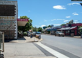
Riverton is a small town in the Mid North of South Australia, in the Gilbert Valley. It is situated on the Gilbert River, from which the town derives its name. Both the Gilbert Valley and Gilbert River were named after South Australian pioneer, Thomas Gilbert. Riverton was first settled in 1856, as a settlement along the bullock track from the mining town of Burra to the capital city Adelaide. It grew from a plan designed by a James Masters who had established the nearby town of Saddleworth. The streets of Riverton received their names chiefly from James Masters and his friends. They commemorate persons notable in the history of the district or the State. At the 2011 census, Riverton had a population of 810. Including the rural areas surrounding the town, the population was 1213.

The Clare and Gilbert Valleys Council is a local government area located in the Yorke and Mid North region of South Australia. The council was founded on 1 July 1997 with the amalgamation of the District Council of Clare, the District Council of Riverton and the District Council of Saddleworth and Auburn. The council seat is located at Clare; it also maintains branch offices at Riverton and Saddleworth.

The town of Clare is located in South Australia in the Mid North region, 136 km north of Adelaide. It gives its name to the Clare Valley wine and tourist region.
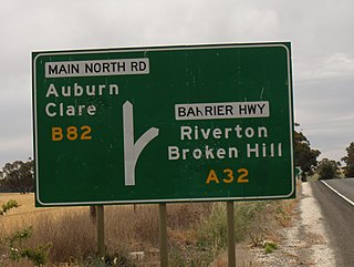
Giles Corner is the name of the intersection of Main North Road and the Barrier Highway, halfway between the towns of Tarlee and Rhynie. The Barrier Highway branches off from Horrocks Highway at this location, heading north towards Riverton, Burra and eventually Broken Hill. Horrocks Highway continues in a northerly direction, on to the towns of Rhynie, Auburn and Clare. There is also an unsealed back road starting just north of the junction which heads west and ends at the road between Balaklava and Owen, approximately 20 kilometres away. Although not a town, Giles Corner is sign posted to mark its location.

Coorong is a locality in the Australian state of South Australia which is associated with the lagoon known as the Coorong in the south-east of the state and which overlooks the continental coastline from the mouth of the Murray River about 80 kilometres south-east of the state capital of Adelaide to the immediate north of the town of Kingston SE extending for a distance of at least 140 kilometres (87 mi).

Saddleworth is a small town in the Mid North region of South Australia. The town is situated on the Gilbert River and along with neighbouring towns of Riverton, Rhynie and Tarlee the local area is known as the Gilbert Valley. The town is bisected by the Barrier Highway. At the 2016 census, Saddleworth had a population of 470.

Rhynie is a small town in South Australia, halfway between Tarlee and Auburn, along the Horrocks Highway. It was surveyed and founded in 1859.
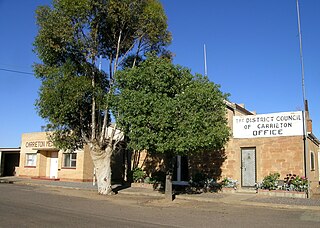
Carrieton is a small town situated in the Flinders Ranges of South Australia. It is located between the towns of Orroroo to the south and Cradock to the north.
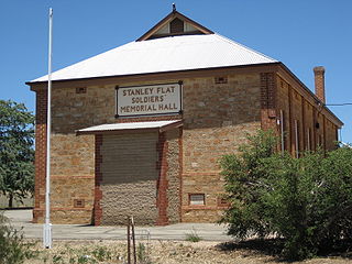
Stanley Flat is a locality in the Mid North region of South Australia about 6 kilometres (3.7 mi) north of Clare along the Horrocks Highway. It is where the Clare Racecourse is situated, as well as an institute hall.

Henley Beach South is a coastal suburb of Adelaide, South Australia. It is located in the City of Charles Sturt.
Queenstown is a north-western suburb of Adelaide about 10.5 km from the CBD, in the state of South Australia, Australia and the city council area of Port Adelaide Enfield.

Undalya is a small rural town on the southern edge of the Clare Valley, in the mid north of the state of South Australia. It is located on the Horrocks Highway approximately halfway between the towns of Auburn and Rhynie, at the junction of the River Wakefield and Pine Creek. To the east lies the town of Saddleworth and to the south-west lies the town of Balaklava. The town was officially gazetted as Undalya in 1859.
The locality of Barinia is situated in South Australia in the Mid North region, approximately 10 km north of Clare. It was a railway siding on the Spalding railway line, which closed in 1984. In November 2009 it became the northern terminus of the Riesling Trail, which utilises the route of the former railway.

Alma is a small town in South Australia halfway between the Wakefield River, to the north, and River Light to the south. Alma, Alma South and Alma Plains were named for the cadastral Hundred of Alma in which they lie, which was in turn named after the Battle of the Alma, the site of an allied victory in the Crimean War.
Sunnyvale or Sunny Vale is a locality and former town in the Australian state of South Australia situated about 10 km south west of Kainton in the upper Yorke Peninsula, consisting mostly of a schoolhouse and Methodist church. Farms nearby were owned by the Lamshed families.

Hill River is a locality in the Yorke and Mid North region of South Australia, about 127 kilometres north of the Adelaide city centre. It is bisected by the Hill River, an ephemeral stream from which it derives its name. Its boundaries were created in January 2001 for the “long established name.”
Sheaoak Flat is a locality in South Australia located on the east coast of Yorke Peninsula immediately adjoining Gulf St Vincent about 71 kilometres north-west of the Adelaide city centre.
Charra is a locality in the Australian state of South Australia located on the state’s west coast overlooking the Great Australian Bight about 584 kilometres north-west of the state capital of Adelaide and about 33 kilometres west of the municipal seat of Ceduna.

The Hundred of Alma is a cadastral unit of hundred located on the northern Adelaide Plains of South Australia spanning the township of Alma and the Alma Plains. The hundred was proclaimed in 1856 in the County of Gawler and named by Governor Richard Graves MacDonnell for the River Alma on the Crimean Peninsula, the location of the Battle of the Alma, the first Allied victory in the Crimean War. The hundred is bounded on the north by the Wakefield River and on the south by the Light River

Woolsheds is a locality in the lower Mid North of South Australia north of the road between Gawler and Mallala.


