Auburn, South Australia

Last updated

Auburn
South Australia
Post Office, Auburn.JPG
Auburn Post Office
Australia South Australia location map.svg
Red pog.svg
Auburn
Location in South Australia
Coordinates 34°01′38″S138°41′08″E / 34.02722°S 138.68556°E / -34.02722; 138.68556 Coordinates: 34°01′38″S138°41′08″E / 34.02722°S 138.68556°E / -34.02722; 138.68556
Population661 (2016 census) [1]
Established1849
Postcode(s) 5451
Location
  • 111 km (69 mi) north of Adelaide
  • 25 km (16 mi) south of Clare
LGA(s) District Council of Clare and Gilbert Valleys
Region Mid North
State electorate(s) Frome
Federal division(s) Grey
Localities around Auburn:
Watervale Leasingham Mintaro
Hoyleton Auburn Manoora
Halbury Undalya Saddleworth

Auburn is a small town in the southern edge of the Clare Valley, in the Mid North of South Australia.

Contents

It lies in the northern Mount Lofty Ranges just east of the Skilly Hills. Auburn is bisected by the Wakefield River as it makes its way to the sea at Port Wakefield.

It has strong poetical themes, being named from a poem and the birthplace of a famed poet.

History

The first European to explore through the Auburn district, in April 1839, was John Hill, who was followed one month later by Edward John Eyre. On 10 March 1840 John Morphett selected a special survey of 4,000 acres on the Wakefield River as land agent for three English investors, Admiral George Lambert, Edward Rice M.P., and Robert Slaney M.P.

Very soon after, just outside the southwest corner of this survey, a pioneering character named William Tateham squatted on the Wakefield River, living in a riverbank dugout from where he provided hospitality to travellers. The spot, which later became the site of Auburn, was for a time named Tateham's Waterhole or Billy Tatum's because of this. [2]

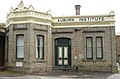
In October 1849, Thomas Henry Williams, a copper-smelting superintendent at the Burra mines, received a land grant for what was to become the Auburn area. During the next few years Williams sold off allotments to bullock teamsters and others. The first building – a well-appointed hotel named the Rising Sun Inn, which still stands – was built in 1850 and so Auburn Village was begun. The hotel's enterprising proprietor, Joseph Edwin Bleechmore (c. 1809–1887), [3] also founded the town's school, which opened in May 1855 under Joseph S. Cole, later of Stanley Grammar School.
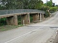
The name of Auburn, probably applied by Williams, is doubtless derived from a line in a poem by Oliver Goldsmith, Sweet Auburn, loveliest village on the plain.

Governance

Auburn is in the District Council of Clare and Gilbert Valleys, the state electoral district of Frome, and the Australian House of Representatives Division of Grey.

Notable residents

Auburn is the birthplace of Australian poet, C. J. Dennis (born 1876), who lived for a time in the former Auburn Hotel, which has since been demolished. A small tributary of the Wakefield River, Dennis Creek runs through the town and was named in honour of his father, who was a local publican 1868–80. The town was also the birthplace of Australian cricketer and Australian Rules football player, Ernie Jones (born 1869). Mary "Maisie" Harriet Archer Thomas nee Smith, wife of South Australian newspaper proprietor Evan Kyffin Thomas and daughter of the local doctor, Arthur William Smith was born at Auburn on 8 October 1878.

The town today

Often considered the Gateway to the Clare Valley, the town is on the Horrocks Highway, approximately 111 kilometres from the state's capital, Adelaide and 25 kilometres south of the town of Clare.

Auburn always was a transport hub. In the 1850s it was on the Gulf Road, used by bullock teamsters carting copper ore from Burra, through Mintaro, to Hoyles Plains and on to Port Wakefield. [4] Today it is on the Horrocks Highway, connecting Adelaide to the north, and also connects the Riverland district with Yorke Peninsula. The southern end of the Riesling Trail also begins here, alongside the former railway station, which is now a winery cellar door.

Auburn has many charming historical buildings. As a result, since the 1970s the town has become a popular tourist destination, with a number of local winery cellar doors and B&Bs. Auburn is serviced by a pub and several cafes, a gallery, roadhouse, bike hire and internet cafe, a post office, hairdresser, Primary School, CFS station, and a number of other services. The Auburn oval hosts sporting facilities for cricket, bowls and netball and is also the location of a small, self-contained caravan park.

Related Research Articles

<span class="mw-page-title-main">Clare Valley wine region</span>

The Clare Valley wine region is one of Australia's oldest wine regions, best known for Riesling wines. It lies in the Mid North of South Australia, approximately 142 km north of Adelaide. The valley runs north-south, with Horrocks Highway as the main thoroughfare.

<span class="mw-page-title-main">Riverton, South Australia</span> Town in South Australia

Riverton is a small town in the Mid North of South Australia, in the Gilbert Valley. It is situated on the Gilbert River, from which the town derives its name. Both the Gilbert Valley and Gilbert River were named after South Australian pioneer, Thomas Gilbert. Riverton was first settled in 1856, as a settlement along the bullock track from the mining town of Burra to the capital city Adelaide. It grew from a plan designed by a James Masters who had established the nearby town of Saddleworth. The streets of Riverton received their names chiefly from James Masters and his friends. They commemorate persons notable in the history of the district or the State. At the 2011 census, Riverton had a population of 810. Including the rural areas surrounding the town, the population was 1213.

<span class="mw-page-title-main">Main North Road</span> Road in South Australia

Main North Road is the major north-south arterial route through the suburbs north of the Adelaide City Centre in the city of Adelaide, South Australia. It continues north through the settled areas of South Australia and is a total of 307 kilometres (191 mi) long, from North Adelaide to 21 kilometres (13 mi) out of Port Augusta. It follows the route established in the early years of the colony by explorer John Horrocks and was a major route for farmers and graziers to reach the capital, passing through rich farmland and the Clare Valley wine region. In 2011, the section of road between Gawler to Wilmington was renamed Horrocks Highway.

<span class="mw-page-title-main">Riesling Trail</span>

The Riesling Trail is a 35 kilometres long walking and cycling track located in the Clare Valley, South Australia. Established for recreational purposes, it runs between Auburn and Clare, passing through several towns and villages along the way, including Leasingham, Watervale, Penwortham and Sevenhill. The trail is named after Riesling, the most important white grape variety in the Clare Valley wine region. It continues 8 kilometres north of Clare to the area known as Barinia.

<span class="mw-page-title-main">Watervale, South Australia</span> Town in South Australia

Watervale is a town on the Horrocks Highway in the Clare Valley, South Australia, approximately 9 kilometres north of Auburn and 15 kilometres south of Clare. It is surrounded by a number of small wineries and several B&Bs. The Riesling Trail runs past the town to the west, between the Highway and the Skilly Hills. The town has a number of 19th-century heritage buildings, including the former Stanley Grammar School, which now provides private bed and breakfast accommodation.

<span class="mw-page-title-main">Penwortham, South Australia</span> Town in South Australia

Penwortham is a small town in the Clare Valley, South Australia, along the Horrocks Highway, approximately 10 kilometres south of Clare and 14 kilometres north of Auburn.

<span class="mw-page-title-main">Tarlee, South Australia</span> Town in South Australia

Tarlee is a town in South Australia. The origin of the name is uncertain, but it is thought to be a corruption of the name Tralee in Ireland. The township of Tarlee was advertised as readied for sale by auction in 1867. Tarlee is in the lower Mid North region where Horrocks Highway crosses the Gilbert River. It is approximately 8 km south of Giles Corner, where the Barrier Highway to Broken Hill diverges from the Horrocks Highway through the Clare Valley. At the 2016 census, Tarlee had a population of 302.

<span class="mw-page-title-main">Balaklava, South Australia</span> Town in South Australia

The town of Balaklava is located in South Australia, 92 kilometres north of Adelaide in the Mid North region. It is on the south bank of the Wakefield River, 25 kilometres east of Port Wakefield.

<span class="mw-page-title-main">Clare, South Australia</span> Town in South Australia

The town of Clare is located in South Australia in the Mid North region, 136 km north of Adelaide. It gives its name to the Clare Valley wine and tourist region.

<span class="mw-page-title-main">Mintaro, South Australia</span> Town in South Australia

Mintaro is a historic town in the eastern Clare Valley, east of the Horrocks Highway, about 126 kilometres north of Adelaide, South Australia. The town lies at the south-eastern corner of the Hundred of Clare, within the Clare Valley wine region. Established in 1849, Mintaro is situated on land which was bought originally by Joseph and Henry Gilbert, which they sub-divided into 80 allotments.

<span class="mw-page-title-main">Giles Corner, South Australia</span> Place in South Australia

Giles Corner is the name of the intersection of Main North Road and the Barrier Highway, halfway between the towns of Tarlee and Rhynie. The Barrier Highway branches off from Horrocks Highway at this location, heading north towards Riverton, Burra and eventually Broken Hill. Horrocks Highway continues in a northerly direction, on to the towns of Rhynie, Auburn and Clare. There is also an unsealed back road starting just north of the junction which heads west and ends at the road between Balaklava and Owen, approximately 20 kilometres away. Although not a town, Giles Corner is sign posted to mark its location.

<span class="mw-page-title-main">Sevenhill, South Australia</span> Town in South Australia

The Australian monastic town of Sevenhill is in the Clare Valley of South Australia, approximately 130 km north of Adelaide. The town was founded by members of the Jesuit order in 1850. The name, bestowed by Austrian Jesuit priest Aloysius Kranewitter, is in homage to the seven hills of Rome.

<span class="mw-page-title-main">Leasingham, South Australia</span> Town in South Australia

Leasingham is the name of a hamlet on the southern edge of the Clare Valley, in the Mid North of South Australia. It is approximately 117 kilometres from the state's capital, Adelaide and 17 kilometres south of the town of Clare.

<span class="mw-page-title-main">Halbury, South Australia</span> Town in South Australia

Halbury is a former railway town in South Australia, west of the Clare Valley, halfway between Balaklava and Auburn. At the 2006 census, Halbury had a population of 363.

<span class="mw-page-title-main">Undalya, South Australia</span> Town in South Australia

Undalya is a small rural town on the southern edge of the Clare Valley, in the mid north of the state of South Australia. It is located on the Horrocks Highway approximately halfway between the towns of Auburn and Rhynie, at the junction of the River Wakefield and Pine Creek. To the east lies the town of Saddleworth and to the south-west lies the town of Balaklava. The town was officially gazetted as Undalya in 1859.

<span class="mw-page-title-main">Wakefield River</span> River in South Australia, Australia

The Wakefield River is an ephemeral river that flows to an estuary in the Australian state of South Australia.

Grosset Wines is an Australian winery based in the Clare Valley wine region of South Australia.

<span class="mw-page-title-main">Taylors Wines</span>

Taylors Wines is a family-owned winery established in 1969 which is located in the Clare Valley of South Australia. Taylors is one of the founding members of the Australia's First Families of Wine.

<span class="mw-page-title-main">Clare Valley</span> Region in South Australia

The Clare Valley is a valley located in South Australia about 100 kilometres north of Adelaide in the Clare and Gilbert Valleys council area. It is the river valley formed by the Hutt River but is also strongly associated with the roughly parallel Hill River. The valley is traversed by the Horrocks Highway and the towns in the valley along that route from south to north are Auburn, Leasingham, Watervale, Penwortham, Sevenhill and Clare. The geographical feature has given rise to the Clare Valley wine region designation, a notable winegrowing region of Australia.

The Spalding railway line was a railway line on the South Australian Railways network which branched from the Peterborough line at Riverton and passed through the Clare Valley to Spalding. The line opened from Riverton to Clare on 5 July 1918, being extended to Spalding on 9 January 1922. The cessation of railway services was a consequence of the Ash Wednesday bushfires in February 1983, which caused major damage to infrastructure between Sevenhill and Penwortham. The line was formally closed on 17 April 1984.

References

  1. Australian Bureau of Statistics (27 June 2017). "Auburn". 2016 Census QuickStats. Retrieved 5 January 2018. OOjs UI icon edit-ltr-progressive.svg
  2. Northern Argus newspaper, 28 February 1882, p. 2. (ref: Billy Tatum's Waterhole)
  3. "The Late Mr. J. E. Bleechmore, J.P." The Northern Argus . Vol. XIX, no. 1, 660. South Australia. 12 August 1887. p. 3. Retrieved 24 February 2018 via National Library of Australia.
  4. Chronicle newspaper, 5 December 1946, p. 48.