Penwortham, South Australia

Last updated

Penwortham
South Australia
Penwortham, northern entrance.JPG
Northern entrance sign along Horrocks Highway
Population163 (SAL 2021) [1]
Established1839
Postcode(s) 5453
Location
  • 124 km (77 mi) north of Adelaide
  • 10 km (6 mi) south of Clare
LGA(s) District Council of Clare and Gilbert Valleys
Region Clare Valley
State electorate(s) Frome
Federal division(s) Grey
Localities around Penwortham:
Spring Gully Sevenhill Polish Hill River
Kybunga Penwortham Mintaro
Hoyleton Watervale
Leasingham
Manoora

Penwortham ( 33°55′S138°38′E / 33.917°S 138.633°E / -33.917; 138.633 ) is a small town in the Clare Valley, South Australia, along the Horrocks Highway, approximately 10 kilometres south of Clare and 14 kilometres north of Auburn.

Contents

Geography

Penwortham is surrounded by natural eucalyptus bushland and a section of the Skilly Hills, which in turn forms part of the Mount Lofty Ranges. There are two significant peaks nearby, Mount Oakden named after John Oakden, and Mount Horrocks, named after John Horrocks. The Hill River rises about 3 kilometres east of Penwortham.

History

The village of Penwortham was founded by settler, pioneer and explorer, John Horrocks (22 March 1818 – 23 September 1846). Horrocks arrived in the colony of South Australia on his 21st birthday, 22 March 1839, less than three years after its proclamation by Governor John Hindmarsh. After meeting Edward John Eyre, who told him of potentially good farmland to the north of Adelaide, John Horrocks and a servant, John Green, set off to find the area Eyre had described to him. Horrocks settled in a region that he believed to be along the Hutt River and named his establishment Hope Farm. Later in 1839, the first stone cottage of the settlement was commenced and, in 1840, Horrocks and his servants built stone stables for horses, which were then very rare and valuable in the new colony. For a short time, this was the only inland European settlement north of Adelaide and Gawler.

The following year saw the completion of an inn, The Derby Arms, which was built to accommodate the many new travellers passing north through Penwortham. The year after that (1842), the first foundations were laid for a flour mill, which did not see full operation until 1856, when all its working parts finally arrived from Europe. 1842 was also the year that the first foundation stone was laid down for the beginning of the manor house at Hope Farm.

Old cottage located at Penwortham, surrounded by grapevines Old cottage, Penwortham.JPG
Old cottage located at Penwortham, surrounded by grapevines

Horrocks died in 1846 as a result of a hunting accident at Lake Gill, just north of the present day city of Port Augusta. By that time, Penwortham had become quite an established town and included a butcher, general store, tailor, school and blacksmith. The next year (1847), an unofficial post office began operation, with the local publican, James Bleechmore, acting as postmaster. In 1851, building began on St Mark's Anglican Church. Completion of St Mark's occurred in 1855, with the installation of a bell, turret and porch.

A new era of transport and industry began in 1915, when the construction of the Riverton to Spalding railway line passed through the town. It brought about many changes, and included the demolition of the manor house at Hope Farm, as this was in its direct line. By now, the main industries in the town and surrounding farms were fruit, dried currant and dairy production. These continued until just after the Second World War, when competition from the Riverland meant that a viable industry in the Clare Valley was untenable. As a result, the pre-war advent and post-war continuation of the fledgling wine industry began to flourish in the region.

A monument was built and unveiled on 22 September 1946 commemorating the life, exploration and untimely death of the town's founder, John Ainsworth Horrocks. It was built by Gordon Ross and William Robins and now stands by the side of Main North Road, near St Mark's Church.

Name

Penwortham shares its name with the town of Penwortham in Lancashire, England. Penwortham (in the United Kingdom) was the home of Richard Arkwright, the inventor of the water frame that kick-started the textile industry in the late 18th century. John Horrocks is likely to have been a descendant of Arkwright. Penwortham is a town name with a precise meaning: a settlement on a hill by a ford. Horrocks originally called his settlement Penwortham-on-the-Hill. He was born at his family home of Penwortham Hall, near Preston, Lancashire. The name is a hybrid of the Welsh pen, meaning headland and an Old English word worphamm, meaning enclosed homestead.


The town today

Pearson Wines are located on the Main Road in an old stone building with cellar door.

St. Marks Church cemetery is the burial place of explorer John Horrocks buried in the adjacent cemetery.

John Horrocks Cottage (formerly Greens Cottage), built in 1839 and owned and operated by the local historical society, opens to visitors on the first Sunday of each month.

The Riesling Trail, on the eastern side links the village to Auburn and Clare for walkers and cyclists looking to take in the ambience of the local countryside.

The scenic drive to the Skillogalee Valley, west of the Main North Road (Horrocks Highway), can be accessed from Penwortham. The drive runs past several well-known cellar doors, including Mitchell Wines, Penna Lane Wines, Kilikanoon Wines, and Skillogalee Wines and Restaurant.

Governance

Penwortham is in the District Council of Clare and Gilbert Valleys, the state electoral district of Frome, and the Australian House of Representatives Division of Grey.

Related Research Articles

<span class="mw-page-title-main">Clare Valley wine region</span>

The Clare Valley wine region is one of Australia's oldest wine regions, best known for Riesling wines. It lies in the Mid North of South Australia, approximately 142 km north of Adelaide. The valley runs north-south, with Horrocks Highway as the main thoroughfare.

John Baxter was an Irish convict who became an Australian pioneer, overlander, explorer, and offsider of explorer Edward John Eyre.
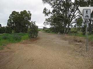
<span class="mw-page-title-main">Penwortham</span> Human settlement in England

Penwortham is a town and civil parish in South Ribble, Lancashire, England, on the south bank of the River Ribble facing the city of Preston. The town is at the most westerly crossing point of the river, with major road and rail links crossing it here. The population of the town at the 2011 census was 23,047.

<span class="mw-page-title-main">Watervale, South Australia</span> Town in South Australia

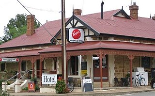
Watervale is a town on the Horrocks Highway in the Clare Valley, South Australia, approximately 9 kilometres north of Auburn and 15 kilometres south of Clare. It is surrounded by a number of small wineries and several B&Bs. The Riesling Trail runs past the town to the west, between the Highway and the Skilly Hills. The town has a number of 19th-century heritage buildings, including the former Stanley Grammar School, which now provides private bed and breakfast accommodation.

<span class="mw-page-title-main">Auburn, South Australia</span> Town in South Australia

Auburn is a small town in the southern edge of the Clare Valley, in the Mid North of South Australia.

<span class="mw-page-title-main">Clare and Gilbert Valleys Council</span> Local government area in South Australia

The Clare and Gilbert Valleys Council is a local government area located in the Yorke and Mid North region of South Australia. The council was founded on 1 July 1997 with the amalgamation of the District Council of Clare, the District Council of Riverton and the District Council of Saddleworth and Auburn. The council seat is located at Clare; it also maintains branch offices at Riverton and Saddleworth.

<span class="mw-page-title-main">Clare, South Australia</span> Town in South Australia

The town of Clare is located in South Australia in the Mid North region, 136 km north of Adelaide. It gives its name to the Clare Valley wine and tourist region.

<span class="mw-page-title-main">John Ainsworth Horrocks</span> Australian explorer

John Ainsworth Horrocks was an English pastoralist and explorer who was one of the first European settlers in the Clare Valley of South Australia where, in 1840, he established the village of Penwortham.

<span class="mw-page-title-main">Skilly Hills</span> Range of hills in South Australia

The Skilly Hills are a range of hills which make up part of the Mount Lofty Ranges in South Australia's Mid North region.

<span class="mw-page-title-main">Mintaro, South Australia</span> Town in South Australia

Mintaro is a historic town in the eastern Clare Valley, east of the Horrocks Highway, about 126 kilometres north of Adelaide, South Australia. The town lies at the south-eastern corner of the Hundred of Clare, within the Clare Valley wine region. Established in 1849, Mintaro is situated on land which was bought originally by Joseph and Henry Gilbert, which they sub-divided into 80 allotments.

<span class="mw-page-title-main">John Reynell</span>

John Reynell was an English-born emigrant to the colony of South Australian where he became established as a wheat farmer, a sheep and cattle breeder, and a vigneron and winemaker.

<span class="mw-page-title-main">Sevenhill, South Australia</span> Town in South Australia

The Australian monastic town of Sevenhill is in the Clare Valley of South Australia, approximately 130 km north of Adelaide. The town was founded by members of the Jesuit order in 1850. The name, bestowed by Austrian Jesuit priest Aloysius Kranewitter, is in homage to the seven hills of Rome.

<span class="mw-page-title-main">Leasingham, South Australia</span> Town in South Australia

Leasingham is the name of a hamlet on the southern edge of the Clare Valley, in the Mid North of South Australia. It is approximately 117 kilometres from the state's capital, Adelaide and 17 kilometres south of the town of Clare.

<span class="mw-page-title-main">Wakefield River</span> River in South Australia, Australia

The Wakefield River is an ephemeral river that flows to an estuary in the Australian state of South Australia.

<span class="mw-page-title-main">Hill River (South Australia)</span> River in South Australia, Australia

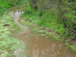
The Hill River is an ephemeral river located in the Mid North region of the Australian state of South Australia.

<span class="mw-page-title-main">John Jackson Oakden</span>

John Jackson Oakden, pastoralist, was an English explorer of South Australia, part of the European exploration of Australia, and a pioneer runholder of the Canterbury region of New Zealand.

John Hill was an English explorer of South Australia and part of the European exploration of Australia. Hill was the first European to see and traverse the Clare Valley.

<span class="mw-page-title-main">Clare Valley</span> Region in South Australia

The Clare Valley is a valley located in South Australia about 100 kilometres north of Adelaide in the Clare and Gilbert Valleys council area. It is the river valley formed by the Hutt River but is also strongly associated with the roughly parallel Hill River. The valley is traversed by the Horrocks Highway and the towns in the valley along that route from south to north are Auburn, Leasingham, Watervale, Penwortham, Sevenhill and Clare. The geographical feature has given rise to the Clare Valley wine region designation, a notable winegrowing region of Australia.

<span class="mw-page-title-main">James Stein</span>

James Stein was a pioneering settler of the Mid North of South Australia and founder of the Kadlunga pastoralism estate.

<span class="mw-page-title-main">Hill River, South Australia</span> Town in South Australia

Hill River is a locality in the Yorke and Mid North region of South Australia, about 127 kilometres north of the Adelaide city centre. It is bisected by the Hill River, an ephemeral stream from which it derives its name. Its boundaries were created in January 2001 for the “long established name.”

References

  1. Australian Bureau of Statistics (28 June 2022). "Penwortham (suburb and locality)". Australian Census 2021 QuickStats. Retrieved 28 June 2022.  OOjs UI icon edit-ltr-progressive.svg