Hoyleton, South Australia

Last updated

Hoyleton
South Australia
Old goods shed, Hoyleton.JPG
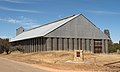
Original goods shed, built in the 1870s
Australia South Australia location map.svg
Red pog.svg
Hoyleton
Coordinates 34°01′25″S138°33′43″E / 34.02361°S 138.56194°E / -34.02361; 138.56194 Coordinates: 34°01′25″S138°33′43″E / 34.02361°S 138.56194°E / -34.02361; 138.56194
Population283 (2006 census Census) [1]
LGA(s) Wakefield Regional Council
Region Mid North
County Stanley
State electorate(s) Goyder
Federal division(s) Grey
Localities around Hoyleton:
Bowillia Kybunga
Spring Gully
Watervale
Stow Hoyleton Leasingham
Watchman Halbury Auburn

Hoyleton (formerly Hoyle's Plains) is a former railway town in South Australia, west of the Clare Valley, halfway between Leasingham and Halbury. At the 2006 census, Hoyleton had a population of 283. [1]

Contents

Hoyle's Plains was the original terminus of the Port Wakefield railway line. This was constructed in 1869 as a horse-drawn tramway to assist farmers on the newly settled Hoyles Plains to get their grain to the port. [2]

The Gladstone railway line ran from Balaklava to Blyth and further on into the Mid North of the state. [3] Due to various reasons, this particular line had become obsolete and the tracks were dismantled in the late 1980s. The original historic stone railway shed remains standing alongside the grain silos which are still in use, but now serviced by road.

Sir Walter Watson Hughes, one of the founders of the University of Adelaide, originally owned a pastoral lease at Hoyleton in the 1850s. He later went on to own vast copper mining interests at Wallaroo, on the Yorke Peninsula. [4]

The Hoyleton Airbase to the west of the township is a base for firefighting aircraft to quickly respond to reports of fires in the Mid North region.

Government

Hoyleton is in the Wakefield Regional Council local government area, the State Electoral District of Goyder and the Federal Electorate of Grey.

Related Research Articles

Wakefield Regional Council Local government area in South Australia

Wakefield Regional Council is a local government area in the Yorke and Mid North region of South Australia. The council seat is at Balaklava.

Rail transport in South Australia

The first railway in colonial South Australia was a line from the port of Goolwa on the River Murray to an ocean harbour at Port Elliot, which first operated in December 1853, before its completion in May 1854.

Roseworthy, South Australia Town in South Australia

Roseworthy is a small town in South Australia, about 10 km north of Gawler on the Horrocks Highway. At the 2016 census, Roseworthy had a population of 994.

Owen, South Australia Town in South Australia

Owen is a rural community in the heart of the Adelaide Plains. Owen is 46 metres (150 ft) above sea-level and receives a reliable 416 mm of rain annually and was first settled in about 1865. It is about 80 km north of Adelaide in South Australia and is approximately 40 minutes by road to the nearest main regional centre of Gawler. It is in the Wakefield Regional Council.

Port Wakefield, South Australia Town in South Australia

Port Wakefield is a town at the mouth of the River Wakefield, at the head of the Gulf St Vincent in South Australia. It was the first government town to be established north of the state capital, Adelaide. Port Wakefield is situated 98.7 kilometres from the Adelaide city centre on the Port Wakefield Highway section of the A1 National Highway.

Auburn, South Australia Town in South Australia

Auburn is a small town in the southern edge of the Clare Valley, in the Mid North of South Australia.

Balaklava, South Australia Town in South Australia

The town of Balaklava is located in South Australia, 92 kilometres north of Adelaide in the Mid North region. It is on the south bank of the Wakefield River, 25 kilometres east of Port Wakefield.

Blyth, South Australia Town in South Australia

Blyth is a small town in the Mid North of South Australia, located 13 kilometres (8.1 mi) west of the renowned Clare Valley. The town is located on the lands of the Kaurna people, the indigenous people who lived there before European settlement. It has a population of 306, the farming community spanning the plains between the Clare Hills and the Barunga/Hummocks ranges. Altitude is 189 metres (620 ft), and rainfall is approximately 400 millimetres (16 in) per annum.

Bowmans is a locality in South Australia's Mid North. At the 2006 census, Bowmans had a population of 203. It is named after R and C Bowman who were "pastoralists in area."

Paskeville, South Australia Town in South Australia

Paskeville is a town on South Australia's Yorke Peninsula. It is located approximately 20 km east of Kadina on the Copper Coast Highway towards Adelaide. At the 2016 census, Paskeville had a population of 178. The town's district is administratively divided between the Copper Coast Council and the District Council of Barunga West.

Leasingham, South Australia Town in South Australia

Leasingham is the name of a hamlet on the southern edge of the Clare Valley, in the Mid North of South Australia. It is approximately 117 kilometres from the state's capital, Adelaide and 17 kilometres south of the town of Clare.

Halbury, South Australia Town in South Australia

Halbury is a former railway town in South Australia, west of the Clare Valley, halfway between Balaklava and Auburn. At the 2006 census, Halbury had a population of 363.

Adelaide Plains Council Local government area in South Australia

The Adelaide Plains Council is a local government area in South Australia. It consists of a largely rural region along the Gulf St Vincent, covering a total area of approximately 926 km2. The council seat lies at Mallala, but it also maintains a service centre at Two Wells.

Lochiel, South Australia Town in South Australia

Lochiel is a small town in the Mid North of South Australia 125 km (78 mi) north of Adelaide. The town lies beside on the western edge of Lake Bumbunga and at the eastern foot of the Hummocks Range. The Augusta Highway, a section of Highway 1, runs on a strip between the township and the lake, which dwarfs the former.

Nantawarra, South Australia Town in South Australia

Nantawarra is a locality in South Australia located about 120 kilometres north of the Adelaide city centre and within the local government area known as the Wakefield Regional Council. The locality occupies land on both sides of Highway 1 between Port Wakefield in the south and Snowtown in the north. Nantawarra is recognisable from a distance by the presence of grain silos immediately just east of the Adelaide-Port Augusta railway line. The name Nantawarra may derive from the word nantuwara in Kaurna, the language of the indigenous people of this part of South Australia.

Bumbunga, South Australia Town in South Australia

Bumbunga is a locality in the Mid North of South Australia 125 kilometres (78 mi) north of Adelaide. It lies 5 kilometres (3.1 mi) east of Lake Bumbunga.

Wooroora was an electoral district of the House of Assembly in the Australian colony of South Australia.

Balaklava-Moonta railway line

The Balaklava-Moonta railway line was a railway line on the South Australian Railways network. It ran across the top of the Yorke Peninsula.

Long Plains, South Australia Town in South Australia

Long Plains is a rural locality and small township on the northern Adelaide Plains in South Australia, 73 km north of Adelaide. It is divided between the Wakefield Regional Council and the Adelaide Plains Council. The formal boundaries were established in 1997 for the long established local name with respect of the section in the Adelaide Plains Council; the portion in the Wakefield Council was added in January 2000.

South Hummocks is a locality in the Mid North of South Australia at the head of Gulf St Vincent adjacent to Yorke Peninsula on the southeastern slopes of the Hummock Range.

References

  1. 1 2 Australian Bureau of Statistics (25 October 2007). "Hoyleton (State Suburb)". 2006 Census QuickStats. Retrieved 30 July 2011.
  2. "THE PORT WAKEFIELD AND HOYLE'S PLAINS TRAMWAY, AND THE DISTRICT THROUGH WHICH IT PASSES". The Express and Telegraph . Adelaide, SA: National Library of Australia. 27 November 1869. p. 2 Edition: SECOND EDITION. Retrieved 2 December 2015.
  3. The Centenary of the Port Wakefield and Hoyleton Railway Wilson, John Australian Railway Historical Society Bulletin, January, 1970 pp. 17–23
  4. Cockburn, Rodney (1999). South Australia – What's in a Name?. Axiom Publishing. ISBN   0-9592519-1-X.