Lake Bumbunga

Last updated

Lake Bumbunga
Lake Bumbunga satellite view in summer.jpg
Satellite view of 15 square km Lake Bumbunga in summer, when the water level is at its lowest
(click to enlarge)
Australia South Australia relief location map.png
Red pog.svg
Lake Bumbunga
Location in South Australia
Location Mid North region, South Australia
Coordinates 33°54′S138°11′E / 33.900°S 138.183°E / -33.900; 138.183
Type Salt lake
Basin  countriesAustralia
Surface area13.88 km2 (5.36 sq mi) [1]

Lake Bumbunga is a salt lake located in the Mid North of the state of South Australia, between the town of Lochiel and the farming locality of Bumbunga, approximately 1.5 hours' drive from Adelaide. It is a pink lake, with its colour due to certain algae.

Contents

Salt has been mined there almost continuously since 1881, and it has become a tourist attraction, along with its "Loch Eel Monster" sculpture in the middle of it.

History

The lake lies in the traditional lands of the Kaurna people. [2] [3]

According to anthropologist Norman Tindale, the name Bumbunga derives from the word parnpangka in the local Aboriginal language (Kaurna), meaning "rain water lake". [4]

Description

View looking east from Hwy 1 rest stop, late spring 2010 Lake Bumbunga salt lake at Lochiel, South Australia in 2010.jpg
View looking east from Hwy 1 rest stop, late spring 2010

The lake is situated in the Mid North of South Australia, approximately 125 km (78 mi) [5] (1.5 hours' drive) from the state capital city, Adelaide. [6] Easily visible from Highway 1 for a distance of 10 km (6.2 mi), the 15-square-kilometre (5.8 sq mi) [7] Lake Bumbunga is a dramatic departure from the surrounding landscape due to its seasonal pink colouration and wide expanse. [8] The colour is due to a certain type of algae which tolerates its high salinity and produces pink pigment that helps it to take energy. The colour does change from time to time, for instance it may be pinker in spring than winter, owing to more fresh water bringing nutrients to the algae, and there's more sunlight than the winter months. Summers are dry and the water evaporates. [5]

The lake is the largest of a system of Quaternary Holocene saline lakes extending about 30 km (19 mi) north of Lochiel, draining an area to the east of the Barunga Range, where it merges with the Hummock Range. Salt is dissolved from saline mud produced when winter rain fills the lake. [9] Each summer a large portion of the lake dries up. [8]

Salt harvesting

Salt harvesting at Lake Bumbunga in the late 1940s Salt harvesting, Lake Bumbunga, South Australia, late 1940s.jpg
Salt harvesting at Lake Bumbunga in the late 1940s

Salt is precipitated from gypsum, are precipitated out at this stage.[ further explanation needed ] The water is then pumped into crystallising ponds, where common salt precipitates. The process is stopped before all the salt comes down in order to avoid contamination with magnesium and potassium salts. The final liquors, known as bitterns, are drained away from the salt, which is then harvested. At Lake Bumbunga, brine is pumped into three 25 hectare (62 acre) crystalliser ponds for refining. [9]

The potential of Lake Bumbunga's shallow waters for salt harvesting was recognised in 1868. Salt was harvested from the lake bed in summer months from 1881; two years later, output was 6.1 to 8.1 tonnes (6 to 8 long tons) per day. Evaporation pans, furnaces, tank and men's quarters were built at the northern end of the lake. Mining provided employment and other economic benefits for many years; the town of Lochiel, on the west bank of the lake, is said to have "developed slowly with the industry, its survival in the 20th century being almost totally dependent on the salt harvesting". [8] [10] By 1910 there were at least three lease-holders scraping thousands of tons of salt from evaporation pans when the lake dried up – usually in December. [8] In 1913, the Australian Salt Company was incorporated and held all the lake leases until 1971, when the company became a wholly owned subsidiary of Cheetham Salt Company Limited – now Cheetham Salt Limited, Australia's largest producer and refiner of solar salt. [11] [note 1]

Efficiency of transportation was improved in 1926 after a 9 km (5.5 mi) [12] branch line was built from the nearby Salisbury railway line, [13] enabling transport directly to Port Adelaide. [10] [note 2] During World War II, when salt was need for munitions manufacture, employment rose from 30 to 100 workers, with three shifts a day, and two trains a week transported the product in bags. [14] In 1967, 1000 tonnes a day were harvested; at that time South Australia was producing 80 per cent of Australia's salt, although that soon decreased, with major expansion of solar salt production in Western Australia. Forty years later, average annual production was reported as 10,000 tonnes (11,000 tons). [9] From 1996 to 2012, the works closed and no salt was harvested. [14] With harvesting becoming practicable using only front-end loaders and trucks, the maintenance and salt works buildings became redundant and were demolished in 2000. [7] [8]

Tourism

"Loch Eel", visible from the northern approaches to Lochiel Lake Bumbunga near Lochiel, South Australia, with its quirky 'Loch Eel' sculpture.jpg
"Loch Eel", visible from the northern approaches to Lochiel

The lake is a tourist attraction owing to its pinkness, with its popularity growing in recent years, attracting stops by tourist buses. [6]

A fibreglass sculpture named the "Loch-Eel monster" (wordplay on Lochiel, the nearest town, whose namesake is a forest in northern Scotland [6] ) is visible in the middle of the lake. The backstory for the monster harks back to a time when bullock (ox) teams were common, in the late 1880s. The story goes that bullocks were walking over the lake when they were "spooked by some sort of monster, went to the wrong part of the lake... and gradually got sucked under and went down". [5] The original version of the monster was created from piles of old tyres, and locals called it the Loch Ness monster's cousin. After the head got stolen in 2017, work began on the fibreglass replacement. [6]

There is a walking trail around the lake for tourists. [5]

Other uses

The lake has been used as background for advertising by R. M. Williams, Mercedes-Benz, Foxtel and others, as well as fashion shoots for the Adelaide Fashion Festival. Tim Minchin used Lake Bumbunga as a filming location for his TV series Upright , [6] with a cast of more than 50 people on the lake. [5]

See also

Notes

  1. In 1992, Cheetham Salt Limited was acquired by Ridley Corporation Limited, an Australian listed company. In 2013, CK Life Sciences Int’l., (Holdings) Inc. acquired Cheetham Salt Limited. [11]
  2. The line left the BowmansSnowtown section of the mainline between Adelaide and Redhill (Port Pirie after 1937) at Bumbunga passing siding ( 33°54′45″S138°13′45″E / 33.9125°S 138.2292°E ). It headed south-west on the northern side of Leslie McIntyre Road (now Blyth Road), then at the southern tip of Lake Bumbunga swung north between the lake and Highway 1, terminating 1.5  km north of the town ( 33°54′51″S138°09′49″E / 33.9141°S 138.1637°E ).

Related Research Articles

<span class="mw-page-title-main">Great Salt Lake</span> Salt lake in Utah, United States

The Great Salt Lake is the largest saltwater lake in the Western Hemisphere and the eighth-largest terminal lake in the world. It lies in the northern part of the U.S. state of Utah and has a substantial impact upon the local climate, particularly through lake-effect snow. It is a remnant of Lake Bonneville, a prehistoric body of water that covered much of western Utah.

<span class="mw-page-title-main">Salt lake</span> Landlocked body of water which has a high concentration of salts

A salt lake or saline lake is a landlocked body of water that has a concentration of salts and other dissolved minerals significantly higher than most lakes. In some cases, salt lakes have a higher concentration of salt than sea water; such lakes can also be termed hypersaline lakes, and may also be pink lakes on account of their colour. An alkalic salt lake that has a high content of carbonate is sometimes termed a soda lake.

<span class="mw-page-title-main">Province of Bumbunga</span> Micronation in Australia

The Province of Bumbunga was an Australian secessionist micronation located on a farm at Bumbunga near Snowtown and Lochiel, South Australia, from 1976 until approximately 2000. Its founder and only ruler was a British monkey trainer, uranium prospector, and postmaster named Alec Brackstone.

<span class="mw-page-title-main">Lake Magadi</span> Lake Kajiado County, Kenya

Lake Magadi is the southernmost lake in the Kenyan Rift Valley, lying in a catchment of faulted volcanic rocks, north of Tanzania's Lake Natron. During the dry season, it is 80% covered by soda and is well known for its wading birds, including flamingos.

<span class="mw-page-title-main">Lake Grassmere</span> Lagoon in Marlborough Region, South Island

Lake Grassmere / Kapara Te Hau is a New Zealand waituna-type lagoon in the northeastern South Island, close to Cook Strait. The lake is used for the production of salt.

<span class="mw-page-title-main">Salt evaporation pond</span> Shallow artificial pond designed to extract salts from sea water or other brines,

A salt evaporation pond is a shallow artificial salt pan designed to extract salts from sea water or other brines. The salt pans are shallow and expansive, allowing sunlight to penetrate and reach the seawater. Natural salt pans are formed through geological processes, where water evaporating, leaving behind salts deposits. Some salt evaporation ponds are only slightly modified from their natural version, such as the ponds on Great Inagua in the Bahamas, or the ponds in Jasiira, a few kilometres south of Mogadishu, where seawater is trapped and left to evaporate in the sun.

<span class="mw-page-title-main">Snowtown, South Australia</span> Town in South Australia

Snowtown is a town located in the Mid North of South Australia 145 km north of Adelaide and lies on the main road and rail routes between Adelaide and Perth – the Augusta Highway and Adelaide-Port Augusta railway line. The town's elevation is 103 metres and on average the town receives 389 mm of rainfall per annum.

<span class="mw-page-title-main">Lake Retba</span> Pink-colored lake in Senegal

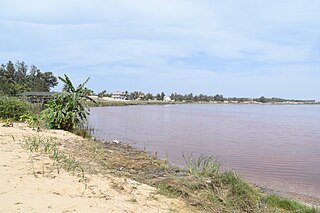
Lake Retba, also known as Lac Rose, lies north of the Cap Vert peninsula in Senegal, some 35 km (22 mi) north-east of the capital, Dakar, in northwest Africa. It is named for its pink waters caused by Dunaliella salina algae and is known for its high salt content, up to 40% in some areas. Its colour is usually particularly strong from late January to early March, during the dry season; however, flooding in September 2022 not only disrupted salt harvesting activities on the lake, but because it caused the lake to lose its colour, had a negative effect on tourism.

<span class="mw-page-title-main">Wakefield Regional Council</span> Local government area in South Australia

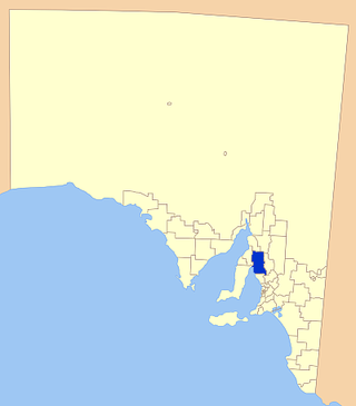
Wakefield Regional Council is a local government area in the Yorke and Mid North region of South Australia. The council seat is at Balaklava.

<i>Dunaliella salina</i> Species of alga

Dunaliella salina is a type of halophile unicellular green algae especially found in hypersaline environments, such as salt lakes and salt evaporation ponds. Known for its antioxidant activity because of its ability to create large amount of carotenoids, it is responsible for most of the primary production in hypersaline environments worldwide, and is also used in cosmetics and dietary supplements.

<span class="mw-page-title-main">Lake Tyrrell</span> Lake in Victoria, Australia

Lake Tyrrell is a shallow, salt-crusted depression in the Mallee district of north-west Victoria, in Australia. The name 'Tyrrell' is derived from the local Wergaia word for 'sky', the Boorong Aboriginal people of the area being distinguished for their interest in star-lore. The Boorong, with their astronomical traditions, told stories connected with constellations in the night sky.

<span class="mw-page-title-main">Lochiel, South Australia</span> Town in South Australia

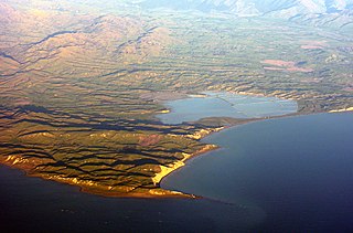
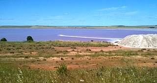
Lochiel is a small town in the Mid North of South Australia 125 km (78 mi) north of Adelaide. The town lies beside on the western edge of Lake Bumbunga and at the eastern foot of the Hummocks Range. The Augusta Highway, a section of Highway 1, runs on a strip between the township and the lake, which dwarfs the former.

<span class="mw-page-title-main">Pink lake</span> Pink lake phenomenon and examples

A pink lake is a lake that has a red or pink colour. This is often caused by the presence of salt-tolerant algae that produces carotenoids, such as Dunaliella salina, usually in conjunction with specific bacteria, which may vary from lake to lake. The most common archea is Halobacterium salinarum.

Pink Lake (Western Australia) Salt lake in the Goldfields-Esperance region, Western Australia

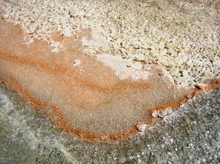
Pink Lake is a salt lake in the Goldfields-Esperance region of Western Australia. Although historically the water in the lake was visibly pink, as of 2017 it had not been pink for over ten years. Salt concentration is vital to Pink Lake's pink hue, and Pink Lake may turn pink again as conditions change. It lies about 3 kilometres (2 mi) west of Esperance and is bounded to the east by the South Coast Highway.

<span class="mw-page-title-main">Price, South Australia</span> Town in South Australia

Price is a town and locality on Yorke Peninsula in South Australia. It is within the Yorke Peninsula Council local government area and is 131 kilometres (81 mi) north west of the centre of state capital, Adelaide.

<span class="mw-page-title-main">Bumbunga, South Australia</span> Town in South Australia

Bumbunga is a locality in the Mid North of South Australia 125 kilometres (78 mi) north of Adelaide. It lies 5 kilometres (3.1 mi) east of Lake Bumbunga.

The Hummocks or Hummock Range is a range of hills in the northern Mount Lofty Ranges extending north from the eastern edge of Yorke Peninsula in South Australia. It is traversed by the Copper Coast Highway immediately west of where it passes around the northern end of Gulf St Vincent. The Augusta Highway passes to the east of the Hummocks. The Hummock Range includes the settlements of South Hummocks and Kulpara. Towards the range's northern end it continues as the Barunga Range north of Barunga Gap, approximately 10 kilometres (6.2 mi) south west of Snowtown.

Everard Central is a locality in South Australia's Mid North. The locality is situated in approximately the southern two thirds of the cadastral Hundred of Everard.

<span class="mw-page-title-main">Hundred of Cameron</span> Cadastral in South Australia

The Hundred of Cameron is a cadastral unit of hundred located in the Mid North of South Australia centred on Lake Bumbunga. The northern Hummock Range occupies much of the western half of the area and the Adelaide-Port Augusta railway line runs near and parallel to the eastern boundary. It is one of the 16 hundreds of the County of Daly. It was named in 1869 by Governor James Fergusson for early pioneer Hugh Cameron.

Pink Lake (Victoria) Australian salt lake

Pink Lake is a small, circular, salty pink lake on the Western Highway just north of Dimboola in Australia. Granville Stapylton, part of the explorer Thomas Mitchell's 1836 expedition into western Victoria, reconnoitered Pink Lake on 20 July 1836.

References

  1. Wetland inventory, northern agricultural districts of South Australia Archived 2009-10-17 at the Wayback Machine , An assessment of selected inland wetlands of the Northern Agricultural Districts. (page 16)
  2. "Lake Bumbunga – The Pink Lake". Kids in Adelaide. Retrieved 28 February 2023.
  3. Horton, David R. (1996). "Map of Indigenous Australia". AIATSIS . Retrieved 28 February 2023.
  4. "Place Names of South Australia - B - Bumbunga". Manning Index of South Australian History. State Library of South Australia. Archived from the original on 3 March 2016. Retrieved 15 July 2016. Index compiled based on Manning, Geoffrey H. (2006). Manning's Place Names of South Australia from Aaron Creek to Zion Hill. Modbury, South Australia: Gould Books. ISBN   9780947284602.
  5. 1 2 3 4 5 Sulda, Dixie (17 February 2023). "South Australia's Lake Bumbunga attracts tourists from far and wide. But why is it pink?". ABC News. Retrieved 28 February 2023.
  6. 1 2 3 4 5 Jones, Kate (29 March 2021). "Escape to Lochiel, South Australia: Great for crowds and pink lake pics for the socials". Domain . Retrieved 28 February 2023.
  7. 1 2 "Lake Bumbunga, Lochiel, North Mt Lofty Ranges, Mt Lofty Ranges, South Australia, Australia". mindat.org. Hudson Institute of Mineralogy. 2019. Retrieved 26 October 2019.
  8. 1 2 3 4 5 "Heritage survey of the Lower North (Region 8 - South Australia) - Part Two: 17. D.C. Snowtown" (PDF). Department of Environment and Planning, Government of South Australia. 1983. p. 8. Retrieved 24 May 2017.
  9. 1 2 3 Hough, Joanne K. (September 2008). "Salt Production In South Australia". MESA Journal. Parkside, SA: [Department of] Mines and Energy South Australia. 50. ISSN   2207-2152.
  10. 1 2 Klaassen, Nic (2019). "Salt mining in South Australia". Flinders Ranges Research. Flinders Ranges Research. Retrieved 23 October 2019.
  11. 1 2 "Historical timeline – Cheetham Salt". Cheetham Salt Limited. Cheetham Salt Limited. 2019. Retrieved 23 October 2019.
  12. Google Earth.
  13. "LOCHIEL-BUMBUNGA". The Register (Adelaide) . Vol. XCI, no. 26, 600. South Australia. 18 November 1926. p. 7. Retrieved 5 November 2019 via National Library of Australia.
  14. 1 2 Fuss, Eloise (1 March 2012). "Lochiel lake harvest stirs salty memories". ABC North and West SA. Australian Broadcasting Corporation. Retrieved 23 October 2019.