
Humber River—Black Creek is a federal electoral district in Toronto, Ontario, Canada, that has been represented in the House of Commons of Canada from 1867 to 1904 and since 1917. Prior to the 2015 election, the riding was known as York West. The former name reflects the riding is in the former Township of York which is within the City of Toronto.

Snowtown is a town located in the Mid North of South Australia 145 km north of Adelaide and lies on the main road and rail routes between Adelaide and Perth – the Augusta Highway and Adelaide-Port Augusta railway line. The town's elevation is 103 metres and on average the town receives 389 mm of rainfall per annum.

Jamestown is a town in the Mid North region of South Australia 207 kilometres (129 mi) north of Adelaide. It lies on the banks of the Belalie Creek and on the Crystal Brook-Broken Hill railway line between Gladstone and Peterborough, and ultimately on the main line linking Adelaide and Perth to Sydney. Jamestown is the council seat of its local municipality, Northern Areas Council. Jamestown is in the South Australian Legislative Assembly electoral district of Stuart and the federal Division of Grey.
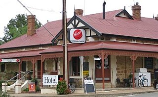
Watervale is a town on the Horrocks Highway in the Clare Valley, South Australia, approximately 9 kilometres north of Auburn and 15 kilometres south of Clare. It is surrounded by a number of small wineries and several B&Bs. The Riesling Trail runs past the town to the west, between the Highway and the Skilly Hills. The town has a number of 19th-century heritage buildings, including the former Stanley Grammar School, which now provides private bed and breakfast accommodation.

The Clare and Gilbert Valleys Council is a local government area located in the Yorke and Mid North region of South Australia. The council was founded on 1 July 1997 with the amalgamation of the District Council of Clare, the District Council of Riverton and the District Council of Saddleworth and Auburn. The council seat is located at Clare; it also maintains branch offices at Riverton and Saddleworth.

The town of Clare is located in South Australia in the Mid North region, 136 km north of Adelaide. It gives its name to the Clare Valley wine and tourist region.

Mintaro is a historic town in the eastern Clare Valley, east of the Horrocks Highway, about 126 kilometres north of Adelaide, South Australia. The town lies at the south-eastern corner of the Hundred of Clare, within the Clare Valley wine region. Established in 1849, Mintaro is situated on land which was bought originally by Joseph and Henry Gilbert, which they sub-divided into 80 allotments.

The Australian monastic town of Sevenhill is in the Clare Valley of South Australia, approximately 130 km north of Adelaide. The town was founded by members of the Jesuit order in 1850. The name, bestowed by Austrian Jesuit priest Aloysius Kranewitter, is in homage to the seven hills of Rome.

Leasingham is the name of a hamlet on the southern edge of the Clare Valley, in the Mid North of South Australia. It is approximately 117 kilometres from the state's capital, Adelaide and 17 kilometres south of the town of Clare.

Lochiel is a small town in the Mid North of South Australia 125 km (78 mi) north of Adelaide. The town lies beside on the western edge of Lake Bumbunga and at the eastern foot of the Hummocks Range. The Augusta Highway, a section of Highway 1, runs on a strip between the township and the lake, which dwarfs the former.
Munno Para is a northern suburb of Adelaide, South Australia. It is located in the City of Playford.

Woolshed Flat is a locality near the southern end of the Clare Valley in South Australia. It is located in the District Council of Clare and Gilbert Valleys.
Stanley was an electoral district of the House of Assembly in the Australian state of South Australia.
Ninnes is a locality at the northeastern corner of Yorke Peninsula and western side of the Mid North of South Australia. It lies where the Upper Yorke Road from Kulpara to Bute is crossed by the road from Paskeville to Lochiel. The dominant industry is broadacre grain and sheep farming.

The Hundred of Clare is a cadastral unit of hundred in the northern Mount Lofty Ranges centred on the town of Clare. It is one of the 16 hundreds of the County of Stanley.
The District Council of Hall was a local government area in South Australia from 1878 to 1935.

The Hundred of Alma is a cadastral unit of hundred located on the northern Adelaide Plains of South Australia spanning the township of Alma and the Alma Plains. The hundred was proclaimed in 1856 in the County of Gawler and named by Governor Richard Graves MacDonnell for the River Alma on the Crimean Peninsula, the location of the Battle of the Alma, the first Allied victory in the Crimean War. The hundred is bounded on the north by the Wakefield River and on the south by the Light River
The Corporation and District Council of Clare were twin local government areas in South Australia centred on the town of Clare. The district council existed from 1853 until 1997, while the town corporation existed from 1868 until 1969.
The Hundred of Stanley is a cadastral unit of hundred in the northern Mount Lofty Ranges. It is one of the 16 hundreds of the County of Stanley.
