The Regional Council of Goyder is a local government area located in the Mid North region of South Australia. The council area is reliant on agriculture as a mainstay of its economy, with manufacturing and tourism also becoming prominent. The council seat is at Burra. A branch office is at Eudunda.
Booborowie is a locality in South Australia. It is located 200 km (124 mi) north of Adelaide. At the 2016 census, the Booborowie district had a population of 218.

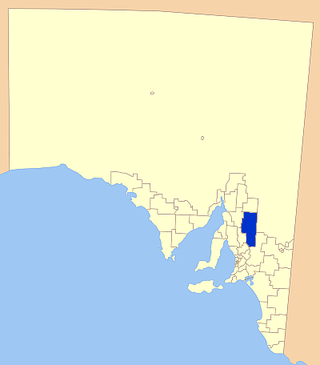
Worlds End is a locality 18 km southeast of Burra in South Australia. It also includes the area formerly known as Lapford.

Bundey is a locality in the Mid North region of South Australia. It is located on Goyder's Line, on the plains between Burra and Morgan in the Regional Council of Goyder. The bounded locality of Bundey corresponds to the boundaries of the cadastral Hundred of Bundey, except for the southwestern corner of the Hundred which is the northeastern corner of the locality of Geranium Plains. Bundey was named in 1878 for politician William Henry Bundey.

Geranium Plains is a small town in the Regional Council of Goyder in South Australia. The post office opened in 1894, but has since closed. There was a proposal to rename it to Iperta in 1916, but this did not go ahead.

Mongolata is a rural locality in the Mid North region of South Australia, situated in the Regional Council of Goyder. The modern locality was established in August 2000, when boundaries were formalised for the "long established local name".
Burra Eastern Districts is a rural locality in the Mid North region of South Australia, situated in the Regional Council of Goyder. It was established in August 2000, when boundaries were formalised for the "long established local name".
Hallelujah Hills is a rural locality in the Mid North region of South Australia, situated in the Regional Council of Goyder.
Apoinga is a rural locality in the Mid North region of South Australia, situated in the Regional Council of Goyder.
Collinsville is a rural locality in the Mid North region of South Australia, situated in the Regional Council of Goyder. It was established in August 2000, when boundaries were formalised for the "long established local name". It has almost exactly the same boundaries as the cadastral Hundred of Tomkinson, with small variations on its western border.
The District Council of Apoinga was a local government area in South Australia from 1873 to 1932.
The District Council of English was a local government area in South Australia from 1878 to 1932.
Baldina is a rural locality in the Mid North region of South Australia, situated in the Regional Council of Goyder. It was established in August 2000, when boundaries were formalised for the "long established local name".
Emu Downs is a rural locality in the Mid North region of South Australia, situated in the Regional Council of Goyder.
Ngapala is a rural locality in the Mid North region of South Australia, situated in the Regional Council of Goyder. It was established in August 2000, when boundaries were formalised for the "long established local name". It is divided between the cadastral Hundreds of English and Julia Creek.
Rocky Plain is a rural locality in the Mid North region of South Australia, situated in the Regional Council of Goyder. It was established in August 2000, when boundaries were formalised for the "long established local name".
Bright is a rural locality in the Mid North region of South Australia, situated in the Regional Council of Goyder. It was established in August 2000, when boundaries were formalised for the "long established local name". It incorporates most of the cadastral Hundred of Bright, which was proclaimed on 17 June 1875 and named for politician Henry Edward Bright.
Porter Lagoon is a rural locality in the Mid North region of South Australia, situated in the Regional Council of Goyder. It was established in August 2000, when boundaries were formalised for the "long established local name". Most of the locality lies in the cadastral Hundred of Hanson; a small strip along the eastern side lies in the Hundred of Apoinga.
Brady Creek is a rural locality in the Mid North region of South Australia, situated in the Regional Council of Goyder. It was established in August 2000, when boundaries were formalised for the "long established local name" for the creek which it is centred on and named after. It is divided between the cadastral Hundreds of Apoinga and English.
The Hundred of English is a cadastral unit of hundred containing all or part of the localities of Brady Creek, Robertstown, Rocky Plain, Geranium Plains, Ngapala, Point Pass, Australia Plains and Eudunda. It is one of the 16 hundreds of the County of Eyre. It was named in 1866 by Governor of South Australia, Dominick Daly after T English MLC (1820–1884), a former mayor of Adelaide and current Member of the colony's Legislative Council at the time.
