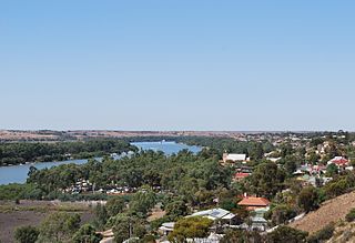
Steinfeld, South Australia

Last updated

Steinfeld
South Australia
Stonefield Lutheran Church 2.JPG
St Stephen's Lutheran Church, Steinfeld
Australia South Australia location map.svg
Red pog.svg
Steinfeld
Coordinates 34°20′50″S139°18′07″E / 34.347280°S 139.301960°E / -34.347280; 139.301960 Coordinates: 34°20′50″S139°18′07″E / 34.347280°S 139.301960°E / -34.347280; 139.301960
Postcode(s) 5356
LGA(s) Mid Murray Council and Regional Council of Goyder
State electorate(s) Stuart
Federal Division(s) Barker
Localities around Steinfeld:
Frankton Brownlow Blanchetown
Dutton East Steinfeld Blanchetown
Truro Annadale Blanchetown

Steinfeld (formerly Stonefield) is a locality in South Australia on the plains east of the Mount Lofty Ranges, and north of the Sturt Highway. The village of Steinfeld was established in the 19th century. It was renamed to Stonefield in 1918 as many places with German or German-sounding names were changed around World War I. The name reverted to Steinfeld in 1986. [1]

South Australia State of Australia

South Australia is a state in the southern central part of Australia. It covers some of the most arid parts of the country. With a total land area of 983,482 square kilometres (379,725 sq mi), it is the fourth-largest of Australia's states and territories by area, and fifth largest by population. It has a total of 1.7 million people, and its population is the second most highly centralised in Australia, after Western Australia, with more than 77 percent of South Australians living in the capital, Adelaide, or its environs. Other population centres in the state are relatively small; Mount Gambier, the second largest centre, has a population of 28,684.

Mount Lofty Ranges mountain in Australia

The Mount Lofty Ranges are the range of mountains just to the east of Adelaide in the Australian state of South Australia.

Sturt Highway Australian national highway in New South Wales, Victoria, and South Australia

The Sturt Highway is an Australian national highway in New South Wales, Victoria, and South Australia. The Sturt Highway is an important road link for the transport of passengers and freight between Sydney and Adelaide and the regions situated adjacent to the route.

The Steinfeld Lutheran congregation was established in 1882, and met in a home until it built its own building in 1890. [2] The congregation met in this building until November 2016. [3] [4] A Lutheran school existed from the 1880s until 1917, when it was forcibly closed by the state government as a result of World War I. It was replaced by a public school in 1917, which operated until 1969. German was the predominant language in the area of the early days of the school, which posed challenges for teachers dealing with children with a poor grasp of English. [5]

In 1945, it was reported that the Automobile Association had erected signs on the BlanchetownTruro road (now the Sturt Highway) indicating that one of the nearest public telephones was at Stonefield. [6]

Truro, South Australia Town in South Australia

Truro is a town in South Australia, 80 km northeast of Adelaide. It is situated in an agricultural and pastoral district on the Sturt Highway, east of the Barossa Valley, where the highway crosses somewhat lofty and rugged parts of the Mount Lofty Ranges. At the 2011 census, Truro had a population of 395.

The main part of the bounded locality now known as Steinfeld, including the original village, is in the Mid Murray Council. The northwestern corner of the locality is in the Regional Council of Goyder. That corner is also in the federal Division of Grey, rather than the Division of Barker like the rest of the locality.

Mid Murray Council Local government area in South Australia

The Mid Murray Council is a local government area in South Australia in the Murray and Mallee region of South Australia. The council spans the area from the Riverland through the Murraylands to the eastern slopes of the Mount Lofty Ranges. It includes 220 km of the Murray River. The council seat is at Mannum; it also maintains secondary offices at Cambrai and Morgan.

Regional Council of Goyder Local government area in South Australia

The Regional Council of Goyder is a local government area located in the Mid North region of South Australia. The council area is reliant on agriculture as a mainstay of its economy, with manufacturing and tourism also becoming prominent. The council seat lies at Burra, with a branch office situated at Eudunda.

Division of Grey Australian federal electoral division

The Division of Grey is an Australian electoral division in South Australia. The division was one of the seven established when the former Division of South Australia was redistributed on 2 October 1903 and is named for Sir George Grey, who was Governor of South Australia from 1841 to 1845.

The Barossa Valley Gliding Club and Adelaide University Gliding club share an airfield at Steinfeld.

Barossa Valley Region in South Australia

The Barossa Valley is a valley in South Australia located 60 kilometres (37 mi) northeast of Adelaide city centre. The valley is formed by the North Para River. It is notable as a major wine-producing region and tourist destination.

Related Research Articles

Murray Bridge, South Australia City in South Australia

Murray Bridge is a city in the Australian state of South Australia, located 76 kilometres (47 mi) east-southeast of the state's capital city, Adelaide, and 77 kilometres (48 mi) north of the town of Meningie. The city had an urban population of approximately 17,500 as at the 2016 Census making it the fifth most populous urban area in the state after Adelaide, Mount Gambier, Victor Harbor - Goolwa and Whyalla.

Hahndorf, South Australia Town in South Australia

Hahndorf is a small town in the Adelaide Hills region of South Australia. Currently an important tourism spot, it has previously been a centre for farming and services. It is accessible from Adelaide, the South Australian capital, via the South Eastern Freeway. The town was settled by Lutheran migrants largely from in and around a small village then named Kay in Prussia and now known as Kije, Lubusz Voivodeship in Poland. Many of the settlers arrived aboard the Zebra on 28 December 1838. The town is named after Dirk Meinerts Hahn, the Danish captain of the Zebra. It is Australia's oldest surviving German settlement.

Morgan, South Australia Town in South Australia

Morgan is a town in South Australia on the right bank of the Murray River, just downstream of where it turns from flowing roughly westwards to roughly southwards. It is about 161 kilometres (100 mi) north east of Adelaide, and about 315 kilometres (196 mi) upstream of the Murray Mouth. At the 2006 census, Morgan had a population of 426.

Coonalpyn, South Australia Town in South Australia

Coonalpyn is a town and a locality in the Australian state of South Australia located about 143 kilometres (89 mi) south-east of the state capital of Adelaide and about 61 kilometres (38 mi) south-east of the municipal seat in Tailem Bend. It is situated in the local government area of the Coorong District Council and is in the State electoratal district of MacKillop and the Federal division of Barker.

Blanchetown Town in South Australia

Blanchetown is a small township in South Australia, on the (west) bank of the Murray River, 130 km northeast of Adelaide. The Blanchetown Bridge is the western-most of the four crossings of the Sturt Highway over the Murray River. During the nineteenth century it was an important transportation centre on the lower Murray. In modern times Blanchetown has been described as "a strange mixture of historic buildings and temporary shacks built by holidaymakers on the banks of the river". Blanchetown is widely regarded as the entrance to the Riverland district.

Mannum Town in South Australia

Mannum is a historic town on the west bank of the Murray River in South Australia, 84 kilometres (52 mi) east of Adelaide. At the 2016 census, the urban area of Mannum had a population of 2,398. Mannum is the seat of the Mid Murray Council, and is situated in the state electoral district of Hammond and the federal Division of Barker.

Lowbank, South Australia Town in South Australia

Lowbank is a locality in South Australia's riverland. It is between the Sturt Highway and the left (south) bank of the Murray River east of Waikerie.

Waterloo, South Australia Town in South Australia

Waterloo is a settlement in South Australia, located just off the Barrier Highway between Manoora and Black Springs, approximately 121 kilometres (75 mi) north-east of the state capital of Adelaide.

Bethel, South Australia Town in South Australia

Bethel is a locality and former settlement in South Australia, west of Kapunda. Its name is derived from the German word for Place of God.

Bundey, South Australia Town in South Australia

Bundey is a locality in the Mid North region of South Australia. It is located on Goyder's Line, on the plains between Burra and Morgan in the Regional Council of Goyder. The bounded locality of Bundey corresponds to the boundaries of the cadastral Hundred of Bundey, except for the southwestern corner of the Hundred which is the northeastern corner of the locality of Geranium Plains. Bundey was named in 1878 for politician William Henry Bundey.

Geranium Plains, South Australia Town in South Australia

Geranium Plains is a small town in the Regional Council of Goyder in South Australia. The post office opened in 1894, but has since closed. There was a proposal to rename it to Iperta in 1916, but this did not go ahead.

Gomersal, South Australia Town in South Australia

Gomersal is a locality on the western side of the Barossa Valley in South Australia. It is between the Sturt Highway and the North Para River and town of Tanunda on the valley floor. Prior to 1918, it was known as New Mecklenburg, but like many others, the name was changed due to anti-German sentiment in World War I. The new name was derived from the town of Gomersal, West Yorkshire.

Paisley, South Australia Town in South Australia

Paisley is a locality in the Murray Mallee region of South Australia, across the Murray River from Blanchetown, South Australia. It was formally named in September 2000 for the Hundred of Paisley which contains it. The Hundred of Paisley was named by Governor MacDonnell in 1861 for his private secretary, J. G. Paisley.

Neales Flat, South Australia Town in South Australia

Neales Flat is a rural locality southeast of Eudunda in the Mid North region in South Australia. It is in the Regional Council of Goyder.

Sandleton, South Australia Town in South Australia

Sandleton is a locality and former town in South Australia. It is located on the plains on the eastern side of the Mount Lofty Ranges. The current boundaries for the locality were created in 2003 for the long-established name of the area.

Dalkey, South Australia Town in South Australia

Dalkey is a locality in the Mid North of South Australia. It was established as a private subdivision of section 171 in the Hundred of Dalkey on the main road from Adelaide to Balaklava. It is named for the Hundred of Dalkey which in turn was named after Dalkey in Ireland. The boundaries of the locality were defined in 2000 for the long-established name.

Peep Hill, South Australia Town in South Australia

Peep Hill is a rural locality in the Mid North region of South Australia, situated in the Regional Council of Goyder. It was established in August 2000, when boundaries were formalised for the "long established local name". It is reported to be named for "a round hill in the last range towards the east".

Milendella, South Australia Town in South Australia

Milendella is a locality on the plains to the east of the Mount Lofty Ranges in South Australia. It was once a stop on the Sedan railway line. The name Milendella was approved by the state Nomenclature Committee in 1917 in advance of the railway opening in 1919. The name was the native name of Emu Creek which runs through the locality.

References

  1. "Placename Details: Steinfeld". Property Location Browser. 9 August 2006. SA0063130. Retrieved 3 March 2015.
  2. Edwin A. Krollig. Krollig Family History 1844-1977. 205 Halifax Street, Adelaide, SA, 78-1: Lutheran Publishing House. p. 79. ISBN   0 9595860 0 8.
  3. "St Stephen's Lutheran Church Stonefield". Lutheran Church Of Australia. Archived from the original on 2 March 2016. Retrieved 19 February 2016.
  4. "Congregations". Mid Murray Lutheran Parish. Retrieved 5 November 2017. St Stephens, Stonefield: Sadly the St Stephens Church was closed on Sunday November 27th, 2016. Attended by the SA/NT District Bishop David Altus, members of the Mid Murray Parish, past members & friends and the surrounding community. The sermon was based on the painted text on the front wall, Psalm 119:105.
  5. Dreckow, Betty (1986). Hills, Valley and Plains: History of the Eudunda District. p. 153.
  6. "Advertising". The Leader . 27 (1406). South Australia. 15 November 1945. p. 3. Retrieved 10 October 2016 via National Library of Australia.