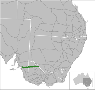
Sturt Highway

Last updated

Sturt Highway

New South Wales
Red B-double truck.jpg
B-double truck on Sturt Highway
Location Sturt Hwy.svg
Coordinates
General information
TypeHighway
Length947 km (588 mi) [1]
Gazetted August 1928 (NSW, as Main Road 58) [2]
August 1933 (NSW, as State Highway 14) [3]
July 1938 (SA) [4]
1939 (VIC) [5]
Route number(s) AUS Alphanumeric Route A20.svg A20 (2013/2017–present)
Former
route number
  • Australian national highway A20.svg National Highway A20 (1997/1998–2013/2017)
    (Gawler–VIC/NSW border)
  • Australian national highway 20.svg National Highway 20 (1992–1997/1998)
    (Gawler–VIC/NSW border)
  • Australian national highway 20.svg National Highway 20 (1992–2013)
    (VIC/NSW border–Tarcutta)
  • Australian national route 20.svg National Route 20 (1955–1992)
    Entire route
Major junctions
West endAUS Alphanumeric Route A20.svg Gawler Bypass
Gawler, South Australia
 
East endAUS Alphanumeric Route M31.svg Hume Motorway
Tarcutta, New South Wales
Location(s)
Region Barossa Light and Lower North, Murray and Mallee, [6] Loddon Mallee, [7] Far West, Riverina, South Western Slopes
Major settlements Nuriootpa, Renmark, Mildura, Balranald, Hay, Narrandera, Wagga Wagga
Highway system

Sturt Highway is an Australian national highway in New South Wales, Victoria, and South Australia. It is an important road link for the transport of passengers and freight between Sydney and Adelaide and the regions along the route. [8]

Contents

Initially an amalgam of trunk routes, the 947-kilometre (588 mi) Sturt Highway was proclaimed a state highway in 1933. In 1955, the Australian Government gazetted the highway as a National Route, and upgraded it to a National Highway in 1992, forming the Sydney-Adelaide Link. Sturt Highway is allocated as route A20 for its entire length, the majority of which is a single carriageway, and freeway standard and 6-lane arterial road standard towards its western terminus in Gawler. [9]

Route

The highway is the shortest, highest-standard route between Sydney and Adelaide. It runs generally east–west, roughly aligned to the southern bank of the Murrumbidgee River in New South Wales. Following that river's confluence with the Murray River, it is then roughly aligned to the Murray through north-western Victoria and eastern South Australia, before it heads towards the northern outskirts of Adelaide. [9]

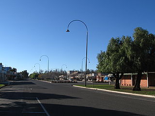
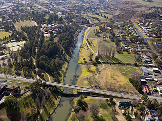
The eastern terminus of Sturt Highway is at a junction with Hume Highway at Tarcutta, near Gundagai. Heading west, the highway passes through the city of Wagga Wagga and the towns Narrandera, Darlington Point, Hay, Balranald, Euston, leaving New South Wales by crossing the Murray River into Victoria from Buronga to Mildura. The highway continues more or less due west through the northwest of Victoria before entering South Australia. In South Australia, Sturt Highway passes Renmark, Monash, Barmera, Waikerie, Blanchetown and Nuriootpa, before reaching its western terminus at the interchange with Gawler Bypass and Northern Expressway on the outskirts of Gawler.

History

The route now known as Sturt Highway originated from stock routes cut across southern New South Wales through the 19th century: overlanders would travel from Sydney's Main South Road (now Hume Highway) to Albury, and follow along the southern bank of the Murray River to Adelaide. Edward John Eyre, the English explorer, travelled from Limestone Plains (now Canberra) to Adelaide via this route in 1837, as did Charles Sturt in 1838. Eyre on his second run to South Australia headed west, following the northern bank of the Murrumbidgee River instead, crossing it at its junction with the Murray close to Boundary Bend, and travelled to Adelaide from there. [5] The road pioneered by Eyre in 1839 left Hume Highway at Gundagai and followed the northern bank of the Murrumbidgee through the sites of Wagga Wagga, Narrandera, Hay and Balranald, and the north bank of the Murray River through the sites of Euston and Wentworth, passing north of Lake Victoria to the border with South Australia and onwards to Renmark. By 1852 a mail service by horseback operated from Wagga Wagga as far west as Balranald. [5]

The route used by coaches between Wagga Wagga and the South Australian border as late as 1914 ran along the northern bank of the Murrumbidgee to Darlington Point – a bridge was built across the river in 1905, replacing a punt service operating from 1886 – and then continued along the river's southern bank to Hay, crossing the river again (a bridge in Hay was opened in 1874 by Sir Henry Parkes, replacing a ferry service operating since the 1850s). [5] The route then travelled the northern side of the Murrumbidgee through Maude and Balranald and onwards to Adelaide. By 1919 the route from Hay had been altered to travel the river's southern bank to Maude, before departing the water course for a more-direct route to Balranald, crossing the river there by a bridge opened in 1876. [5] By 1928, the route had shifted south of the Murrumbidgee River between Tarcutta and Narrandera.

The passing of the Main Roads Act of 1924 [10] through the Parliament of New South Wales provided for the declaration of Main Roads, roads partially funded by the State government through the Main Roads Board (later the Department of Main Roads, and eventually Transport for NSW). Main Road No. 4 was declared along this road from the intersection with Hume Highway from Lower Tarcutta to Wagga Wagga (and continuing eastwards via Tumut, Adaminaby, Cooma, and Bega to Tathra) as part of Monaro Highway, [2] Main Road No. 6 was declared from Balranald via Euston and Wentworth to the state border with South Australia (and continuing eastwards via Oxley, Booligal, Gunbar, Rankins Springs, Wyalong and Cowra to Bathurst) as part of Mid-Western Highway, [2] and Main Road No. 58 was declared from Hay via Narranderra to Wagga Wagga (and continuing westwards via Maude to Oxley), [2] on the same day, 8 August 1928. With the passing of the Main Roads (Amendment) Act of 1929 [11] to provide for additional declarations of State Highways and Trunk Roads, these were amended to State Highways 4 and 6 and Trunk Road 58 on 8 April 1929.

Mid-Western Highway was rerouted between Gunbar and Balranald to pass through Hay, and the western end of Trunk Road 58 was truncated to meet it at Hay, on 24 September 1929. [12] The route of the main road from Narrandera to Darlington Point had shifted to the southern side of the river at this stage, thus following the present route east from Balranald. On 16 September 1930, the road between Wagga Wagga and Hay (Trunk Road 58) was named Sturt Trunk Road, [13] in honour of Captain Charles Sturt who explored the area a century earlier and opened it up for agriculture.

The Department of Main Roads, which had succeeded the MRB in the previous year, declared Sturt Highway as State Highway 14 on 8 August 1933, from the intersection with Hume Highway at Lower Tarcutta via Wagga Wagga, Hay, Balranald, Euston and Wentworth to the state border with South Australia, subsuming the existing portions of Monaro Highway (State Highway 4) between Wagga Wagga and Lower Tarcutta, Sturt Trunk Road (Trunk Road 58) from Wagga Wagga to Hay, and Mid-Western Highway (State Highway 6) from Hay to the state border with South Australia. [14] [15] eventually to Adelaide via Renmark; [3] the western end of Monaro Highway (today Snowy Mountains Highway) was truncated to meet Hume Highway in Tarcutta, and the western end of Mid-Western Highway was truncated to meet Sturt Highway in Hay, as a result. [14] On 1 July 1938, the South Australian government decreed "the road from Gawler through Blanchetown to the border beyond Renmark will be known as the Sturt Highway", to join with the same road in New South Wales. [4]

In 1939, [5] Sturt Highway was rerouted to run via Mildura, using the former alignment of Murray Valley Highway, to make it the most direct route to Adelaide. Murray Valley Highway had been constructed in 1927 to provide a shorter, all-weather road connection between Mildura and Renmark, [16] [17] and was declared a State Highway by the Country Roads Board of Victoria in September 1932. [18]

Sturt Highway was signed National Route 20 across its entire length in 1955. The Whitlam government introduced the federal National Roads Act 1974, [19] where roads declared as a National Highway were still the responsibility of the states for road construction and maintenance, but were fully compensated by the Federal government for money spent on approved projects. [19] :S7 As an important interstate link between the capitals of New South Wales and South Australia, Sturt Highway was declared a National Highway in 1992. With all three states' conversion to their newer alphanumeric systems between the late 1990s to the early 2010s, its former route number was updated to A20 for the highway within Victoria (in 1997), South Australia (in 1998), and eventually the New South Wales section (in 2013). [20]

The passing of the Roads Act of 1993 [21] through the Parliament of New South Wales updated road classifications and the way they could be declared within New South Wales. Under this act, Sturt Highway today retains its declaration as Highway 14, from the intersection with Hume Highway north of Tarcutta to the bridge over the Murray River at Mildura. [22]

The passing of the Road Management Act 2004 [23] through the Parliament of Victoria granted the responsibility of overall management and development of Victoria's major arterial roads to VicRoads: in 2004, VicRoads re-declared Sturt Highway (Arterial #6610) from the border with South Australia at Murray-Sunset to the border with New South Wales in Mildura. [24]

Upgrades

South Australia

None of the Sturt Highway was originally constructed as dual-carriageway. Work began in January 2007 to upgrade the highway to a four-lane, dual-carriageway road between Gawler Bypass and Greenock in the Barossa Valley. The project was completed in 2010 with budget savings directed towards further Sturt Highway improvements. [25]

Northern Expressway was built at the south-western end of Sturt Highway, as part of an AusLink/Government of South Australia project to build a new freeway-standard road, as part of the North–South Corridor project, providing better access for road transport to Port Adelaide and the industrial areas west and northwest of Adelaide. [26]

Other projects in South Australia include a number of overtaking lanes added in the 2000s and 2010s to help make it safer with the high volume of traffic. [27] Major 'S'-bend curves near Waikerie were realigned, and further upgrades to the road were performed up to 2012. [28]

Significant route changes

The original route of Sturt Highway in the Riverland passing through Berri and Glossop was bypassed to pass through Monash in 1995. The former alignment is now known as the Old Sturt Highway, route B201. The original route passed through the middle of the Barossa Valley, along what is now the Barossa Valley Way. [29] [30] This first changed to a route passing to the north of Nuriootpa, around to the north and west of Gawler on the Gawler Bypass and Main North Road to Gepps Cross. It later changed to use the Northern Expressway instead. The more recent road duplication led to it bypassing Daveyston and Shea-Oak Log instead of passing through these small towns.

When the Northern Expressway and Northern Connector were assigned as route M2, route A20 reverted to following Main North Road south to Gepps Cross. [31]

Truro bypass

A new alignment is proposed to be built to the north of the town of Truro, to remove the highway traffic from the main street of the town. The bypass is proposed to be funded by the Australian government for $161.6 million and state government $40.4 million. Construction is expected to start late in 2022 and be completed by the end of 2026. [32] The project will adjust the alignment to reduce the steep hill between the Murray Flats and Truro. It will be built to a standard suitable for triple road trains. [33]

Victoria

There is a proposed Mildura Truck Bypass, to be funded by Auslink 2. [34]

Major river crossings

From east to west, the Sturt Highway follows much of the course of the Murrumbidgee River, on its southern banks, from the Sturt's eastern terminus with the Hume Motorway. At Balranald, the Sturt Highway crosses the Murrumbidgee, carrying the highway to the north of the river via the Balranald Bridge. [35]

To the west and south-west, Sturt Highway crosses the Murray four times:

The bridge at Blanchetown was originally opened in 1964. [38] It replaced cable ferries, and was itself replaced in 1998 [39] in response to concern about its ability to continue to carry B-double trucks. The bridge at Kingston On Murray was opened in 1973, [40] also replacing a very busy ferry crossing.

Major intersections

StateLGA [41] Location [1] [24] [42] km [1] miDestinationsNotes
South Australia Light Gawler BeltWard Belt boundary0.00.0AUS Alphanumeric Route A20.svg Gawler Bypass (A20)  Elizabeth, Gepps Cross Western terminus of highway, route A20 continues southwest along Gawler Bypass
AUS Alphanumeric Route M2.svg Northern Expressway (M2)  Waterloo Corner, Wingfield, Adelaide Westbound entrance to and eastbound exit from Northern Expressway only
Gawler Belt–ReidWillaston tripoint0.20.12 Morgan railway line
Gawler Belt–Reid boundary1.40.87Weyland Road  Gawler, Mallala, Balaklava Westbound entry and exit only
2.01.2Redbanks Road  Gawler, Mallala, Balaklava Eastbound entry and exit only
Gawler Belt–Hewett boundary2.91.8AUS Alphanumeric Route B82.svg Horrocks Highway (B82)  Tarlee, Clare, to AUS Alphanumeric Route B81.svg Thiele Highway (B81)  Freeling, Kapunda
Greenock 2314Greenock Road  Greenock, Kapunda
Nuriootpa 3119AUS Alphanumeric Route B19.svg Barossa Valley Way (B19)  Tanunda, Lyndoch
Mid Murray Truro 4226Truro Road  Kapunda
4427Eudunda Road  Eudunda
Annadale 6540Halfway House Road  Sedan, Mannum Heavy vehicle detour New South Wales detour route D1.svg to South Eastern Freeway via Murray Bridge (D1)
River Murray 9157Blanchetown Bridge
Loxton Waikerie Paisley 9257Hunter Road  Swan Reach, Mannum
Waikerie 12980Old Waikerie Road  Waikerie
Kingston On Murray 166103Kingston Road  Loxton
River Murray168104Kingston Bridge
Berri Barmera Barmera 179111AUS Alphanumeric Route B201.svg Old Sturt Highway (B201)  Berri
Monash 185115AUS Alphanumeric Route B64.svg Goyder Highway (B64)  Morgan, Crystal Brook
194121AUS Alphanumeric Route B201.svg Old Sturt Highway (B201)  Berri
River Murray211131 Paringa Bridge
Renmark Paringa Pike River 222138Stanitzki Road  Loxton, Murray Bridge
State border234145South Australia – Victoria state border
Victoria Mildura Neds Corner 268167Meringur North Road  Meringur
Mildura 343213AUS Alphanumeric Route A79.svg Seventeenth Street (Calder Highway) (A79 north)  Merbein, Wentworth, Broken Hill Concurrency with route A79
345214AUS Alphanumeric Route A79.svg Fifteenth Street (Calder Highway) (A79 south)  Ouyen, Bendigo, Melbourne
347216AUS Alphanumeric Route C256.svg Eleventh Street (C256)  Merbein, Mildura
348216 Mildura railway line
349217AUS Alphanumeric Route C255.svg Seventh Street (C255)  Irymple
State border351218Victoria – New South Wales state border
New South Wales Murray River 353219 George Chaffey Bridge
Wentworth Buronga 352219AUS Alphanumeric Route B79.svg Silver City Highway (B79)  Wentworth, Broken Hill
Balranald Euston 431268 Murray Valley Highway   Robinvale, Swan Hill
Murrumbidgee River 509316Balranald Bridge
Balranald Balranald 510320Ivanhoe Road  Ivanhoe
511318Yanga Way  Tooleybuc, to AUS Alphanumeric Route B12.svg Mallee Highway (B12)  Ouyen, Adelaide
Hay Maude 583362Maude Road  Maude, Moulamein
Hay 638396AUS Alphanumeric Route B75.svg Cobb Highway (B75)  Wilcannia, Echuca, to AUS Alphanumeric Route B64.svg Mid-Western Highway (B64)  West Wyalong, Cowra Roundabout
Murrumbidgee Darlington Point 752467AUS Alphanumeric Route B87.svg Kidman Way (B87)  Griffith, Cobar, Jerilderie
Narrandera Narrandera 807501 Tocumwal railway line
808502AUS Alphanumeric Route A39.svg Newell Highway (A39 south)  Jerilderie Concurrency with route A39
809503AUS Alphanumeric Route A39.svg Newell Highway (A39 north)  West Wyalong, Parkes, Dubbo
Wagga Wagga Wagga Wagga 899559AUS Alphanumeric Route A41.svg Olympic Highway (A41 south)  Albury Concurrency with route A41
902560AUS Alphanumeric Route A41.svg Olympic Highway (A41 north)  Junee
904562 Main Southern railway line
Tarcutta 947588AUS Alphanumeric Route M31.svg Hume Motorway (M31)  Albury, Sydney, Canberra Eastern terminus of highway and route A20

Towns on Sturt Highway

See also

Related Research Articles

<span class="mw-page-title-main">Murray River</span> Longest river in Australia

The Murray River is a river in Southeastern Australia. It is Australia's longest river at 2,508 km (1,558 mi) extent. Its tributaries include five of the next six longest rivers of Australia. Together with that of the Murray, the catchments of these rivers form the Murray–Darling basin, which covers about one-seventh the area of Australia. It is widely considered Australia's most important irrigated region.

<span class="mw-page-title-main">Hume Highway</span> Major national highway in Australia

Hume Highway, inclusive of the sections now known as Hume Freeway and Hume Motorway, is one of Australia's major inter-city national highways, running for 840 kilometres (520 mi) between Melbourne in the southwest and Sydney in the northeast. Upgrading of the route from Sydney's outskirts to Melbourne's outskirts to dual carriageway was completed on 7 August 2013.

<span class="mw-page-title-main">Murrumbidgee River</span> Major river in southeastern Australia

The Murrumbidgee River is a major tributary of the Murray River within the Murray–Darling basin and the second longest river in Australia. It flows through the Australian state of New South Wales and the Australian Capital Territory, descending 1,500 metres (4,900 ft) over 1,485 kilometres (923 mi), generally in a west-northwesterly direction from the foot of Peppercorn Hill in the Fiery Range of the Snowy Mountains towards its confluence with the Murray River near Boundary Bend.

<span class="mw-page-title-main">Charles Sturt</span> Australian explorer (1795-1869)

Charles Napier Sturt was a British officer and explorer of Australia, and part of the European exploration of Australia. He led several expeditions into the interior of the continent, starting from Sydney and later from Adelaide. His expeditions traced several of the westward-flowing rivers, establishing that they all merged into the Murray River, which flows into the Southern Ocean. He was searching to prove his own passionately held belief that an "inland sea" was located at the centre of the continent. He reached the rank of Captain, served in several appointed posts, and on the Legislative Council.

<span class="mw-page-title-main">Wagga Wagga</span> City in New South Wales, Australia

Wagga Wagga is a major regional city in the Riverina region of New South Wales, Australia. Straddling the Murrumbidgee River, with an urban population of more than 71,241 as of 2023, Wagga Wagga is the state's second largest inland city after Maitland, and is an important agricultural, military, and transport hub of Australia. The ninth largest inland city in Australia, Wagga Wagga is located midway between the two largest cities in Australia—Sydney and Melbourne—and is the major regional centre for the Riverina and South West Slopes regions.

<span class="mw-page-title-main">Silver City Highway</span> Highway in New South Wales, Australia

Silver City Highway is a 683-kilometre-long (424 mi) highway that links Buronga, New South Wales to the Queensland border via Wentworth, Broken Hill, and Tibooburra, in the arid Far West region of New South Wales; a short branch also connects to Calder Highway on the Victorian border at Curlwaa. The namesake of the highway is derived from the moniker for Broken Hill – the "Silver City" – which the highway travels through. The highway is designated route B79 from Broken Hill to Buronga.

<span class="mw-page-title-main">Balranald</span> Town in New South Wales, Australia

Balranald is a town within the local government area of Balranald Shire, in the Murray region of New South Wales, Australia.

<span class="mw-page-title-main">Hay, New South Wales</span> Town in New South Wales, Australia

Hay is a town in the western Riverina region of south western New South Wales, Australia. It is the administrative centre of Hay Shire local government area and the centre of a prosperous and productive agricultural district on the wide Hay Plains.

<span class="mw-page-title-main">Cobb Highway</span> Highway in New South Wales

Cobb Highway is a state highway in the western Riverina and the far western regions of New South Wales, with a short section in Victoria, Australia, designated part of route B75.

<span class="mw-page-title-main">Mid-Western Highway</span> Highway in New South Wales

Mid-Western Highway, sometimes Mid Western Highway, is a 518-kilometre (322 mi) state highway located in the central western and northern Riverina regions of New South Wales, Australia. The highway services rural communities and links the Great Western, Mitchell, Olympic, Newell, Cobb and Sturt highways. Mid-Western Highway forms part of the most direct route road link between Sydney and Adelaide, with its eastern terminus in Bathurst and western terminus in Hay. It is designated part of route A41 between Bathurst and Cowra, and route B64 between Cowra and Hay.

<span class="mw-page-title-main">Renmark, South Australia</span> Town in South Australia

Renmark is a town in South Australia's rural Riverland area, and is located 254 km (157.83 mi) northeast of Adelaide, on the banks of the River Murray. The Sturt Highway between Adelaide and Sydney runs through the town; Renmark is the last major town encountered in South Australia when driving this route. It is a few kilometres west of the SA–Victoria and SA–NSW borders. It is 31 m (101.71 ft) above sea level.

<span class="mw-page-title-main">Olympic Highway</span> Highway in New South Wales

Olympic Highway is a 317-kilometre (197 mi) rural road in the central western and south-eastern Riverina regions of New South Wales, Australia. It services rural communities, links Hume Highway with Mid-Western Highway, and provides part of an alternate road link between Sydney and Albury via Bathurst and Cowra as well as servicing Wagga Wagga, linking with Sturt Highway.

<span class="mw-page-title-main">Riverina</span> Region in New South Wales, Australia

The Riverina is an agricultural region of south-western New South Wales, Australia. The Riverina is distinguished from other Australian regions by the combination of flat plains, warm to hot climate and an ample supply of water for irrigation. This combination has allowed the Riverina to develop into one of the most productive and agriculturally diverse areas of Australia. Bordered on the south by the state of Victoria and on the east by the Great Dividing Range, the Riverina covers those areas of New South Wales in the Murray and Murrumbidgee drainage zones to their confluence in the west.

<span class="mw-page-title-main">Tarcutta</span> Town in New South Wales, Australia

Tarcutta is a town in south-western New South Wales, Australia. The town is 438 kilometres (272 mi) south-west of Sydney, 3 kilometres (1.9 mi) east of the Hume Highway, It was proclaimed as a village on 28 October 1890. As of 2016, the town had a population of 446.

<span class="mw-page-title-main">Murray Valley Highway</span> Highway in Victoria and New South Wales

Murray Valley Highway is a 663-kilometre (412 mi) state highway located in Victoria and New South Wales, Australia. The popular tourist route mostly follows the southern bank of the Murray River and effectively acts as the northernmost highway in Victoria. For all but the western end's last three kilometres, the highway is allocated route B400.

<span class="mw-page-title-main">Main North Road</span> Road in South Australia

Main North Road is the major north–south arterial route through the suburbs north of the Adelaide City Centre in the city of Adelaide, South Australia, and linking to Gawler on Adelaide's outer north-eastern fringes.

<span class="mw-page-title-main">Blanchetown</span> Town in South Australia

Blanchetown is a small township in South Australia, on the (west) bank of the Murray River, 130 kilometres (81 mi) northeast of Adelaide. The Blanchetown Bridge is the westernmost of the four crossings of the Sturt Highway over the Murray River. During the nineteenth century it was an important transportation centre on the lower Murray. In the early 21st century, Blanchetown has been described as "a strange mixture of historic buildings and temporary shacks built by holidaymakers on the banks of the river". Blanchetown is widely regarded as the entrance to the Riverland district.

Gawler Bypass is a major north–south route in the outer northern suburbs of the city of Adelaide, South Australia, connecting Main North Road to the Sturt Highway, bypassing Gawler. The route was built in 1963 in an attempt to redirect traffic on the national highway out of Gawler town centre. It has been upgraded and realigned several times since then.

Sandleton is a locality and former town in South Australia. It is located on the plains on the eastern side of the Mount Lofty Ranges. The current boundaries for the locality were created in 2003 for the long-established name of the area.

The Hambledon Homestead is a heritage-listed residence and former inn and store at Tarcutta Street, Tarcutta, in the City of Wagga Wagga local government area of New South Wales, Australia. It is also known as Tarcutta Station. It was added to the New South Wales State Heritage Register on 2 April 1999.

References

  1. 1 2 3 Google (10 October 2021). "Sturt Highway" (Map). Google Maps . Google. Retrieved 10 October 2021.
  2. 1 2 3 4 "Main Roads Act, 1924-1927". Government Gazette of the State of New South Wales. No. 110. 17 August 1928. pp. 3814–20. Archived from the original on 3 August 2022. Retrieved 1 August 2022 via National Library of Australia.
  3. 1 2 "State's Chief Highways Named". The Chronicle . Adelaide: National Library of Australia. 16 June 1938. p. 47. Retrieved 9 September 2014.
  4. 1 2 "NEW MAIN ROADS SCHEDULE". The Advertiser . Adelaide: National Library of Australia. 15 June 1938. p. 25. Retrieved 31 October 2022.
  5. 1 2 3 4 5 6 "Historical Roads of New South Wales" (PDF). NSW Main Roads. Sydney: OpenGov NSW. September 1954. pp. 10–4.
  6. "Location SA Map viewer with regional layers". Government of South Australia . Retrieved 16 June 2022.
  7. "Victoria's Regions". Regional Development Victoria. Victoria State Government. 11 August 2021. Retrieved 16 June 2022.
  8. Hema, Maps (2007). Australia Road and 4WD Atlas (Map). Eight Mile Plains Queensland: Hema Maps. pp. 32–33, 69, 71. ISBN   978-1-86500-456-3.
  9. 1 2 "Sturt Highway". Ozroads. Retrieved 25 May 2008.[ self-published source ]
  10. State of New South Wales, An Act to provide for the better construction, maintenance, and financing of main roads; to provide for developmental roads; to constitute a Main Roads Board Archived 11 August 2022 at the Wayback Machine 10 November 1924
  11. State of New South Wales, An Act to amend the Main Roads Act, 1924-1927; to confer certain further powers upon the Main Roads Board; to amend the Local Government Act, 1919, and certain other Acts; to validate certain payments and other matters; and for purposes connected therewith. Archived 12 August 2022 at the Wayback Machine 8 April 1929
  12. "Main Roads Act, 1924-1929". Government Gazette of the State of New South Wales. No. 132. National Library of Australia. 4 October 1929. p. 4084. Archived from the original on 26 August 2022. Retrieved 26 August 2022.
  13. "Main Roads Act, 1924-1929". Government Gazette of the State of New South Wales. No. 139. National Library of Australia. 19 September 1930. p. 3707. Archived from the original on 26 August 2022. Retrieved 26 August 2022.
  14. 1 2 "Main Roads Act, 1924-1931". Government Gazette of the State of New South Wales. No. 131. National Library of Australia. 25 August 1933. p. 3093. Archived from the original on 26 August 2022. Retrieved 26 August 2022.
  15. Kass, Terry (February 2006). "RTA Thematic History" (PDF) (2nd ed.). Roads & Traffic Authority. p. 84. Retrieved 23 July 2013.
  16. "THE MURRAY VALLEY ROAD". Murray Pioneer and Australian River Record . Renmark, SA: National Library of Australia. 18 November 1927. p. 6. Retrieved 17 June 2014.
  17. "MURRAY VALLEY ROAD". Murray Pioneer and Australian River Record . Renmark, SA: National Library of Australia. 6 April 1928. p. 4. Retrieved 24 June 2014.
  18. "Country Roads Board Victoria. Twentieth Annual Report: for the year ended 30 June 1933". Country Roads Board of Victoria. Melbourne: Victorian Government Library Service. 10 November 1933. pp. 4, 6.
  19. 1 2 National Roads Act 1974 (Cth)
  20. "Road number and name changes in NSW" (PDF). Roads & Maritime Services . Government of New South Wales. 2012. Archived from the original (PDF) on 25 March 2016. Retrieved 7 November 2016.
  21. State of New South Wales, An Act to make provision with respect to the roads of New South Wales; to repeal the State Roads Act 1986, the Crown and Other Roads Act 1990 and certain other enactments; and for other purposes. Archived 11 August 2022 at the Wayback Machine 10 November 1924
  22. Transport for NSW (August 2022). "Schedule of Classified Roads and Unclassified Regional Roads" (PDF). Government of New South Wales. Archived from the original (PDF) on 25 August 2022. Retrieved 1 August 2022.
  23. State Government of Victoria. "Road Management Act 2004" (PDF). Government of Victoria. Archived (PDF) from the original on 18 October 2021. Retrieved 19 October 2021.
  24. 1 2 VicRoads. "VicRoads – Register of Public Roads (Part A) 2015" (PDF). Government of Victoria. p. 1002. Archived from the original on 1 May 2020. Retrieved 19 October 2021.
  25. "Sturt Highway Upgrade". Department of Transport, Energy & Infrastructure. 25 August 2008. Retrieved 15 July 2008.
  26. "Northern Expressway". Department of Transport, Energy & Infrastructure. 11 September 2008. Retrieved 13 September 2008.
  27. "Sturt Highway – Riverland passing lanes". AusLink . Department of Transport and Regional Services. 20 July 2005. Archived from the original on 18 May 2007. Retrieved 11 June 2006.
  28. "Sturt Highway – Upgrading Program". AusLink . Department of Infrastructure and Regional Development. 15 October 2012. Retrieved 12 September 2014.
  29. "THE LOWER MURRAY". The Riverine Grazier . Hay, NSW: National Library of Australia. 15 February 1949. p. 1. Retrieved 9 September 2014.
  30. South Australia. Highways and Local Government Dept; South Australian Government Tourist Bureau (1950), South Australia showing main road system and important district roads, Highways & Local Government Dept. : M.E. Sherrah, Government photolithographer, retrieved 30 January 2015
  31. "Road Route Numbers". Location SA Map Viewer. Retrieved 18 September 2020.
  32. "Truro Bypass". Australian Government Department of Infrastructure, Transport, Regional Development and Communications . Retrieved 17 March 2022.
  33. "Truro Bypass Project". Government of South Australia Department for Infrastructure and Transport . Retrieved 17 March 2022.
  34. Mildura Truck Bypass – Auslink 2(PDF)
  35. "Map of Balranald, NSW". Bonzle Digital Atlas of Australia. Retrieved 2 April 2015.
  36. "George Chaffey Bridge over Murray River, Mildura". Heritage and conservation register. Roads & Maritime Services, Government of New South Wales. 17 April 2009. Retrieved 2 April 2015.
  37. 1 2 3 "The river as a highway: Crossing the Murray". SA memory. State Library of South Australia, Government of South Australia. 31 March 2010. Archived from the original on 31 March 2015. Retrieved 2 April 2015.
  38. "The Official opening of Blanchetown Bridge by the Honourable Sir Thomas Playford G.C.M.G., M.P., Premier of South Australia, on Friday, 24th April, 1964 : souvenir". Highways Department. Government of South Australia. 1964. Retrieved 8 September 2014.
  39. "From one side to the other, to commemorate the opening of the new bridge, November 1998". Blanchetown Bulletin Committee. 1998. Retrieved 8 September 2014.
  40. "Official opening, Kingston Bridge, River Murray by His Excellency the Governor Sir Mark Oliphant, K.B.E. 21st. Feb., 1973". Highways Department. Government of South Australia. 1973. Retrieved 8 September 2014.
  41. "Location SA Map viewer with LGA layers". Government of South Australia . Retrieved 16 June 2022.
  42. "Location SA Map viewer with suburb layers". Government of South Australia . Retrieved 16 June 2022.