Wentworth Shire

Last updated

Wentworth Shire
New South Wales
Wentworth LGA NSW.png
Location in New South Wales
Coordinates 34°05′S141°54′E / 34.083°S 141.900°E / -34.083; 141.900
Population7,453 (LGA 2021) [1]
 • Density0.26/km2 (0.67/sq mi)
Established23 January 1879 [2]
Area26,269 km2 (10,142.5 sq mi)
MayorDaniel Linklater (Independent)
Council seat Wentworth
Region Far West
State electorate(s) Murray
Federal division(s) Farrer
Wentworth Shire Council Logo.png
Website Wentworth Shire
LGAs around Wentworth Shire:
OACDT (SA) Unincorporated Far West Central Darling
OACDT (SA)Wentworth Shire Balranald
Renmark Paringa (SA) Mildura (Vic) Mildura (Vic)

Wentworth Shire is a local government area in the far south-west Riverina region of New South Wales, Australia. This Shire is located adjacent to the Murray and Darling Rivers. The Shire's major roads are the Sturt and the Silver City Highways. The Shire includes the towns of Wentworth, Buronga, Gol Gol, Dareton and Pooncarie. The shire's namesake is explorer and politician William Wentworth. [3]

Contents

The mayor of Wentworth Shire Council is Cr. Daniel Linklater, an Independent politician.

Heritage listings

Wentworth Shire has a number of heritage-listed sites, including:

Council

The area of Wentworth was proclaimed a municipality on 23 January 1879. [2] The first Mayor was Mr. W. Gunn who held office from 1879 to 1880. [9]

Current composition and election method

Wentworth Shire Council is composed of nine councillors elected proportionally as a single ward. All councillors are elected for a fixed four-year term of office. The mayor is elected by the councillors at the first meeting of the council. The most recent election was held on 4 December 2021 and the current makeup of the council is as follows: [10]

PartyCouncillors
  Independents and Unaligned9
Total9

The current Council, elected in 2021, in order of election, is: [10]

CouncillorPartyNotes
 Peter Crisp Independent
 Steve Cooper Independent
 Tim Elstone Independent
 Daniel Linklater Independent Mayor 2023– [11]
 Susan Nichols Independent Deputy Mayor 2023– [11]
 Greg Evans Independent
 Brian Beaumont Independent
 Jo RoddaUnaligned
 Steve HeywoodUnalignedPassed away 7 February 2024 [11]

Localities

Locality population20162021
Arumpo 3440
Buronga 1,2121,252
Curlwaa 393496
Dareton 501456
Ellerslie 8256
Gol Gol 1,5231,596
Mourquong 7975
Pomona 161167
Pooncarie 166226
Wentworth 1,4371,577

Related Research Articles

<span class="mw-page-title-main">Ku-ring-gai Council</span> Local government area in New South Wales, Australia

Ku-ring-gai Council is a local government area in Northern Sydney, in the state of New South Wales, Australia. The area is named after a fictional Aboriginal language group.

<span class="mw-page-title-main">Wentworth, New South Wales</span> Town in New South Wales, Australia

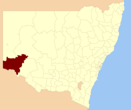
Wentworth is a small border town in the far south west of the state of New South Wales, Australia. It lies at the confluence of Australia's two most important rivers, the Darling and the Murray, the latter forming the border with the state of Victoria to the south. The border with the state of South Australia lies approximately 100 kilometres (62 mi) to the west. The town of Wentworth is in the local government area of the same name.

<span class="mw-page-title-main">Upper Hunter Shire</span> Local government area in New South Wales, Australia

The Upper Hunter Shire is a local government area in the Upper Hunter Valley of New South Wales, Australia. The Shire was formed in May 2004 from the Scone Shire and parts of Murrurundi and Merriwa shires.

<span class="mw-page-title-main">Upper Lachlan Shire</span> Local government area in New South Wales, Australia

Upper Lachlan Shire is a local government area in the Southern Tablelands region of New South Wales, Australia. The Shire was formed in February 2004 from Crookwell Shire and parts of Mulwaree, Gunning and Yass Shires.

<span class="mw-page-title-main">The Hills Shire</span> Local government area in New South Wales, Australia

The Hills Shire is a local government area in the Greater Sydney region of Sydney, New South Wales, Australia. The area is north-west of the Sydney central business district, and encompasses 401 square kilometres (155 sq mi) stretching from the M2 Hills Motorway in the south to Wisemans Ferry on the Hawkesbury River in the north. The Hills Shire had a population of 191,876 as of the 2021 census.

<span class="mw-page-title-main">Warrumbungle Shire</span> Local government area in New South Wales, Australia

The Warrumbungle Shire is a local government area in the central western region of New South Wales, Australia. The Shire is traversed by the Newell Highway. The Warrumbungle mountain range and Warrumbungles National Park are major tourist attractions for the Shire. Its seat is located in Coonabarabran, a town in the southwest.

<span class="mw-page-title-main">City of Blue Mountains</span> Local government area in New South Wales, Australia

The City of Blue Mountains is a local government area of New South Wales, Australia, governed by the Blue Mountains City Council. The city is located in the Blue Mountains, on the Great Dividing Range at the far western fringe of the Greater Sydney area. Major settlements include, Katoomba, Lawson, Springwood and Blaxland.

<span class="mw-page-title-main">City of Penrith</span> Local government area in New South Wales, Australia

The City of Penrith is a local government area in the state of New South Wales, Australia. The seat of the city is located in Penrith, located within Sydney about 50 kilometres (31 mi) west of Sydney central business district. It occupies part of the traditional lands of the Darug people. First incorporated as a municipality on 12 May 1871, on 1 January 1949, the municipalities of Penrith, St Marys and Castlereagh and part of the Nepean Shire amalgamated to form a new Municipality of Penrith. Penrith was declared a City on 21 October 1959, and expanded westwards to include Emu Plains and Emu Heights, formerly part of the City of Blue Mountains, on 25 October 1963. As of the 2021 census the City of Penrith had an estimated population of 217,664.

<span class="mw-page-title-main">Municipality of Woollahra</span> Local government area in New South Wales, Australia

Woollahra Municipal Council is a local government area in the eastern suburbs of Sydney, in the state of New South Wales, Australia. Woollahra is bounded by Sydney Harbour in the north, Waverley Council in the east, Randwick City in the south and the City of Sydney in the west.

<span class="mw-page-title-main">Leeton Shire</span> Local government area in New South Wales, Australia

Leeton Shire is a local government area in the Riverina region of New South Wales, Australia. The Shire is located adjacent to the Murrumbidgee River and falls within the Murrumbidgee Irrigation Area.

<span class="mw-page-title-main">Wollondilly Shire</span> Local government area in New South Wales, Australia

Wollondilly Shire is a periurban local government area, located on the south west fringe of the Greater Sydney area in New South Wales, Australia, parts of which fall into the Macarthur, Blue Mountains and Central Tablelands regions in the state of New South Wales, Australia. Wollondilly is seen as the transition between Regional NSW and the Greater Sydney Region, and is variously categorised as part of both. Wollondilly Shire was created by proclamation in the NSW Government Gazette on 7 March 1906, following the passing of the Local Government (Shires) Act 1905, and amalgamated with the Municipality of Picton on 1 May 1940.

<span class="mw-page-title-main">City of Orange (New South Wales)</span> Local government area in New South Wales, Australia

The City of Orange is a local government area in the Central West region of New South Wales, Australia. Based in Orange, the area is located adjacent to the Mitchell Highway and the Main Western railway line.

<span class="mw-page-title-main">Parkes Shire</span> Local government area in New South Wales, Australia

Parkes Shire is a local government area in the Central West region of New South Wales, Australia. The Shire is located adjacent to the Broken Hill railway line and the Newell Highway.

<span class="mw-page-title-main">Muswellbrook Shire</span> Local government area in New South Wales, Australia

Muswellbrook Shire is a local government area in the Upper Hunter region of New South Wales, Australia. The Shire is situated adjacent to the New England Highway and the Hunter railway line.

<span class="mw-page-title-main">Uralla Shire</span> Local government area in New South Wales, Australia

Uralla Shire is a local government area located in the New England region of New South Wales, Australia. The New England Highway passes through the Shire.

<span class="mw-page-title-main">Armidale Regional Council</span> Local government area in New South Wales, Australia

The Armidale Region is a local government area in the New England and Northern Tablelands regions of New South Wales, Australia. This area was formed in 2016 from the merger of the Armidale Dumaresq Shire with the surrounding Guyra Shire.

<span class="mw-page-title-main">Federation Council, New South Wales</span> Local government area in New South Wales, Australia

Federation Council is a local government area located in the Murray region of New South Wales, Australia, formed in 2016 from the merger of the Corowa Shire with neighbouring Urana Shire.

<span class="mw-page-title-main">Snowy Monaro Regional Council</span> Local government area in New South Wales, Australia

The Snowy Monaro Regional Council is a local government area located in the Snowy Mountains and Monaro regions of New South Wales, Australia. The council was formed on 12 May 2016 through a forced merger of the Bombala, Cooma-Monaro and Snowy River shires.

<span class="mw-page-title-main">Snowy Valleys Council</span> Local government area in New South Wales, Australia

The Snowy Valleys Council is a local government area located in the South West Slopes region of New South Wales, Australia. This area was formed on 12 May 2016 from the merger of the Tumut Shire and Tumbarumba Shire councils.

<span class="mw-page-title-main">Dubbo Regional Council</span> Local government area in New South Wales, Australia

The Dubbo Regional Council is a local government area located in the Central West and Orana regions of New South Wales, Australia. The council was formed on 12 May 2016 through a merger of the City of Dubbo and Wellington Council as part of a widespread council amalgamation program. It was initially named Western Plains Regional Council for almost four months, and its name was changed to Dubbo Regional Council on 7 September 2016.

References

  1. Australian Bureau of Statistics (28 June 2022). "Wentworth (Local Government Area)". Australian Census 2021 QuickStats. Retrieved 28 June 2022.  OOjs UI icon edit-ltr-progressive.svg
  2. 1 2 "Wentworth History". Wentworth Shire Council. Retrieved 23 January 2010.
  3. "Wentworth – A Brief History". Wentworth Shire Council. Archived from the original on 20 May 2024. Retrieved 8 December 2023.
  4. "Rodney – paddle steamer". New South Wales State Heritage Register . Department of Planning & Environment. H01776. Retrieved 18 May 2018. CC BY icon.svg Text is licensed by State of New South Wales (Department of Planning and Environment) under CC-BY 4.0 licence .
  5. "Old Wentworth Gaol". New South Wales State Heritage Register . Department of Planning & Environment. H01982. Retrieved 18 May 2018. CC BY icon.svg Text is licensed by State of New South Wales (Department of Planning and Environment) under CC-BY 4.0 licence .
  6. "St. Ignatius School". New South Wales State Heritage Register . Department of Planning & Environment. H01507. Retrieved 18 May 2018. CC BY icon.svg Text is licensed by State of New South Wales (Department of Planning and Environment) under CC-BY 4.0 licence .
  7. "St. John's Anglican Church and Rectory". New South Wales State Heritage Register . Department of Planning & Environment. H00661. Retrieved 18 May 2018. CC BY icon.svg Text is licensed by State of New South Wales (Department of Planning and Environment) under CC-BY 4.0 licence .
  8. "Avoca Homestead Complex". New South Wales State Heritage Register . Department of Planning & Environment. H01971. Retrieved 18 May 2018. CC BY icon.svg Text is licensed by State of New South Wales (Department of Planning and Environment) under CC-BY 4.0 licence .
  9. "Past Mayors & Presidents". Wentworth Shire Council. Archived from the original on 15 June 2016. Retrieved 23 January 2010.
  10. 1 2 "Wentworth Councillor Election". NSW Electoral Commission. 21 December 2021. Archived from the original on 20 May 2024. Retrieved 20 May 2024. The following candidates were declared elected on 21 December 2021: Peter CRISP Steve COOPER (IND) Tim ELSTONE (IND) Daniel LINKLATER (IND) Susan NICHOLS (IND) Greg EVANS (IND) Brian BEAUMONT Jo RODDA Steve HEYWOOD (IND)
  11. 1 2 3 "Councillors". Wentworth Shire Council. 20 September 2023. Archived from the original on 20 May 2024. Retrieved 20 May 2024.