Tamworth Regional Council

Last updated

Tamworth Regional Council
New South Wales
Tamworth LGA NSW.png
Location in New South Wales
Coordinates 31°05′S150°55′E / 31.083°S 150.917°E / -31.083; 150.917
Population63,070 (2021 census) [1]
 • Density6.3746/km2 (16.5101/sq mi)
EstablishedMarch 2004 [2]
Area9,894 km2 (3,820.1 sq mi) [3]
MayorRussell Webb
Council seat Tamworth
Region New England
State electorate(s) Tamworth
Federal division(s) New England
Tamworthregionalcouncillogo.png
Website Tamworth Regional Council
LGAs around Tamworth Regional Council:
Narrabri Gwydir Uralla
Gunnedah Tamworth Regional Council Walcha
Liverpool Plains Liverpool Plains Upper Hunter

Tamworth Regional Council is a local government area in the New England region of New South Wales, Australia. The area under administration is located adjacent to the New England Highway and the Main North railway line. It was established in March 2004 through the amalgamation of the former City of Tamworth with surrounding shires of Barraba, Manilla, Nundle and Parry. [4]

Contents

The mayor of Tamworth Regional Council is Cr. Russell Webb, an independent politician.

The current Member for the state electoral district of Tamworth is Kevin Anderson, a member of the National Party. [5]

Towns and villages

The area includes the city of Tamworth and the towns and villages of Attunga, Barraba, Bendemeer, Dungowan, Duri, Kootingal, Limbri, Manilla, Moonbi, Niangala, Nundle, Ogunbil, Somerton, Upper Manilla and Woolbrook.

Suburbs

Heritage listings

Tamworth Region has a number of heritage-listed sites, including:

Demographics

At the 2021 census, there were 63,070 people in the Tamworth Regional Local Government Area, of these 49.0 per cent identified as male and 51.0 per cent identified as female. Aboriginal and Torres Strait Islander people made up 12.7 per cent of the population, which was greater than three times higher than the national average of 3.2 per cent. The median age of people in the Tamworth Regional Council was 39 years, which was marginally higher than the national median of 38 years. Children aged 0 – 14 years made up 20.2 per cent of the population and people aged 65 years and over made up 19.8 per cent of the population. Of people in the area aged 15 years and over, 44.6 per cent were married and 11.8 per cent were either divorced or separated. [1]

Population growth in the Tamworth Regional Local Government Area between the 2011 Census and the 2016 Census was 6.0 per cent. When compared with total population growth of Australia for the same period, being 8.8 per cent, population growth in the Tamworth Regional Local Government Area was slightly lower than the national average. [14]

The median weekly income for residents within the Tamworth Regional Council was lower than the national average, this downwards trend compared to the national average was also seen with personal and family incomes. [1]

At the 2021 Census, the proportion of residents in the Tamworth Regional local government area who stated their ancestry as Australian or Anglo-Saxon was about 83.3 per cent of all residents (the national average was around 62.9 per cent). About 49.2% of all residents in the Tamworth Regional Local Government Area nominated a religious affiliation with Christianity at the 2021 Census, which was higher than the national average of approximately 32.4 per cent. Meanwhile, as at the 2021 Census date, compared to the national average, households in the Tamworth Regional Local Government Area had a significantly lower than average proportion (6.8 per cent) where two or more languages are spoken (the national average was 24.8 per cent); and a significantly higher proportion (87.2 per cent) where English only was spoken at home (the national average was 72.0 per cent). [1]

Selected historical Census data for the Tamworth Regional Local Government Area
Census year20012006 [15] 2011 [16] 2016 [14] 2021 [1]
PopulationEstimated residents on Census nightn/a53,590Increase2.svg 56,292Increase2.svg 59,663Increase2.svg 63,070
LGA rank in terms of size within New South Wales 43rdIncrease2.svg 40th
% of New South Wales population0.80%Increase2.svg 0.81%Decrease2.svg 0.80%Decrease2.svg 0.78%
% of Australian populationn/a0.27%Decrease2.svg 0.26%Steady2.svg 0.26%Decrease2.svg 0.24%
Cultural and language diversity
Ancestry,
top responses
Australian 37.5%Decrease2.svg 35.9%Increase2.svg 43.6%
English 31.0%Decrease2.svg 30.1%Increase2.svg 39.7%
Irish 8.5%Increase2.svg 8.6%Increase2.svg 10.7%
Scottish 7.3%Increase2.svg 7.4%Increase2.svg 9.7%
German 3.2%Steady2.svg 3.2%-
Language,
top responses
(other than English)
Tagalog n/cIncrease2.svg 0.1%Increase2.svg 0.4%Increase2.svg 0.5%
Cantonese 0.1%Steady2.svg 0.1%Increase2.svg 0.2%-
Mandarin 0.1%Steady2.svg 0.1%Increase2.svg 0.4%Increase2.svg 0.7%
Filipino 0.2%-
German 0.1%Steady2.svg 0.1%--
Italian 0.1%Steady2.svg 0.1%--
Religious affiliation
Religious affiliation,
top responses
Anglican 38.4%Decrease2.svg 36.2%Decrease2.svg 30.0%Decrease2.svg 24.0%
Catholic 26.5%Decrease2.svg 25.9%Decrease2.svg 24.4%Decrease2.svg 21.8%
No Religion 9.5%Increase2.svg 12.6%Increase2.svg 19.3%Increase2.svg 31.1%
Uniting Church 6.3%Decrease2.svg 5.5%Decrease2.svg 4.4%Decrease2.svg 3.4%
Presbyterian and Reformed 5.3%Decrease2.svg 5.0%--
Median weekly incomes
Personal incomeMedian weekly personal income$405Increase2.svg $515Increase2.svg $633Increase2.svg $755
% of Australian median income86.9%Increase2.svg 89.3%Increase2.svg 95.3%Increase2.svg 93.7%
Family incomeMedian weekly family incomeA$1,041A$1,181A$1,446Increase2.svg $1,821
% of Australian median income88.9%Decrease2.svg 79.7%Increase2.svg 81.2%Increase2.svg 85.8%
Household income Median weekly household incomeA$818A$958A$1,180Increase2.svg $1,416
% of Australian median income79.6%Decrease2.svg 77.6%Increase2.svg 79.4%Increase2.svg 81.0%

Council

Tamworth Regional Council chambers, in Tamworth. Tamworth RC.JPG
Tamworth Regional Council chambers, in Tamworth.

Current composition and election method

Tamworth Regional Council is composed of nine councillors elected proportionally as a single ward. All councillors are elected for a fixed four-year term of office. The mayor is elected by the councillors at the first meeting of the council. The most recent election was held on 4 December 2021, and the makeup of the council is as follows: [17]

PartyCouncillors
  Independent 7
  Independent National 1
  Labor 1
Total9

The current council, elected in 2021, in order of election, is: [17]

CouncillorPartyNotes
 Bede Bourke Independent National Deputy Mayor [18]
 Russell Webb Independent Mayor [18]
 Mark Rodda Independent
 Marc Sutherland Independent
 Phil Betts Independent
 Helen Tickle Independent
 Brooke Southwell Independent
 Stephen Meares Labor
 Judy Coates Independent

Election results

2024

2024 New South Wales local elections: Tamworth [19] [20] [21]
PartyCandidateVotes%±%
Labor 1. Stephen Mears
2. Laura Hughes
3. Thomas Robinson
4. Denise McHugh
5. Sergio Rindo
Greens 1. Ryan Brooke
2. Gemma-Lea Tolmie
3. Sewa Emojong
4. Robin Gunning
5. Catherine Fogarty
Independent Judy Coates
Independent Charles Impey
Independent Brendon North
Independent Jeffrey Budd
Independent Russell Webb
Independent Mark Rodda
Independent Ray Tait
Independent Marie Fenn
Independent Matt Sharpam
Independent National Daniel Gillett
Independent Greg Meyer
Independent Marc Sutherland
Independent National Heidi Williamson
Independent National Bede Burke
Total formal votes
Informal votes
Turnout

Related Research Articles

<span class="mw-page-title-main">Tamworth, New South Wales</span> City in New South Wales, Australia

Tamworth is a city and administrative centre of the north-eastern region of New South Wales, Australia. Situated on the Peel River within the local government area of the Tamworth Regional Council, it is the largest and most populated city in the region, with a population of 43,874 in 2021, making it the second largest inland city in New South Wales. Tamworth is 318 km (198 mi) from the Queensland border and is located almost midway between Brisbane and Sydney.

<span class="mw-page-title-main">Goulburn</span> City in New South Wales, Australia

Goulburn is a regional city in the Southern Tablelands of New South Wales, Australia, approximately 195 kilometres (121 mi) south-west of Sydney and 90 kilometres (56 mi) north-east of Canberra. It was proclaimed as Australia's first inland city through letters patent by Queen Victoria in 1863. Goulburn had a population of 24,565 as of the 2021 census. Goulburn is the seat of Goulburn Mulwaree Council.

<span class="mw-page-title-main">Manilla, New South Wales</span> Town in New South Wales, Australia

Manilla is a small town in New South Wales, Australia, located on Fossickers Way 45 kilometres northwest of the regional city of Tamworth and 27 kilometres northeast of the historic village Somerton. Manilla is famous for its setting as a fishing, paragliding, and mountain biking area. The name Manilla comes from the Gamilaraay word 'Maneela', which is said to mean 'meeting of the rivers'.

<span class="mw-page-title-main">Ku-ring-gai Council</span> Local government area in New South Wales, Australia

Ku-ring-gai Council is a local government area in Northern Sydney, in the state of New South Wales, Australia. The area is named after a fictional Aboriginal language group.

<span class="mw-page-title-main">Upper Hunter Shire</span> Local government area in New South Wales, Australia

The Upper Hunter Shire is a local government area in the Upper Hunter Valley of New South Wales, Australia. The Shire was formed in May 2004 from the Scone Shire and parts of Murrurundi and Merriwa shires.

<span class="mw-page-title-main">Liverpool Plains Shire</span> Local government area in New South Wales, Australia

Liverpool Plains Shire is a local government area located in the North West Slopes region of New South Wales, Australia. The Shire was formed on 17 March 2004 by the amalgamation of Quirindi Shire with parts of Parry, Murrurundi and Gunnedah shires.

<span class="mw-page-title-main">The Hills Shire</span> Local government area in New South Wales, Australia

The Hills Shire is a local government area in the Greater Sydney region of Sydney, New South Wales, Australia. The area is north-west of the Sydney central business district, and encompasses 401 square kilometres (155 sq mi) stretching from the M2 Hills Motorway in the south to Wisemans Ferry on the Hawkesbury River in the north. The Hills Shire had a population of 191,876 as of the 2021 census.

<span class="mw-page-title-main">Hornsby Shire</span> Local government area in New South Wales, Australia

Hornsby Shire is a local government area situated on the Upper North Shore as well as parts of the Hills District, of Sydney in the state of New South Wales, Australia. The shire stretches from the M2 Hills Motorway in the south to the Hawkesbury River town of Wisemans Ferry, some 53 kilometres (33 mi) to the north, making it the largest local government council in the Greater Sydney Metropolitan region by total area. As of the 2016 census the shire had an estimated population of 142,667.

<span class="mw-page-title-main">Municipality of Burwood</span> Local government area in New South Wales, Australia

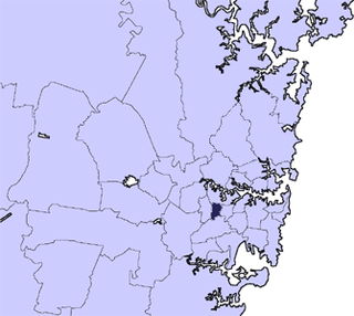
The Municipality of Burwood is a local government area in the inner-west of Sydney, in the state of New South Wales, Australia. The mayor of the Municipality is Cr. John Faker, a member of the Labor Party. The municipality is 7 km2, making it the second smallest Local Government Area in New South Wales, being larger than only Hunter's Hill.

<span class="mw-page-title-main">Municipality of Hunter's Hill</span> Local government area in New South Wales, Australia

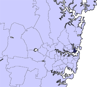
The Municipality of Hunter's Hill or Hunter's Hill Council is a local government area on the Lower North Shore of Sydney, in the state of New South Wales, Australia. The municipality was first proclaimed in 1861, which includes the suburbs of Hunters Hill, Woolwich, Huntleys Point, Tarban, Henley and part of Gladesville. As at the 2021 census, the Municipality had an estimated population of 13,559. At 5.7 square kilometres (2.2 sq mi), the Municipality is, by area, the smallest local government area in New South Wales and its boundaries remain mostly unaltered since its establishment in 1861. The mayor of Hunters Hill since 4 December 2021 is Clr. Zac Miles.

<span class="mw-page-title-main">Lane Cove Council</span> Local government area in New South Wales, Australia

The Lane Cove Council is a local government area located on the Lower North Shore of Sydney, New South Wales, Australia. The administrative seat of Lane Cove is located 10 kilometres (6.2 mi) north-west of the Sydney central business district.

<span class="mw-page-title-main">Mosman Council</span> Local government area in New South Wales, Australia

Mosman Council is a local government area on the Lower North Shore of Sydney, New South Wales, Australia.

<span class="mw-page-title-main">North Sydney Council</span> Local government area in New South Wales, Australia

North Sydney Council is a local government area on the Lower North Shore of Sydney, New South Wales, Australia, established on 29 July 1890 through the amalgamation of three boroughs.

<span class="mw-page-title-main">City of Wagga Wagga</span> Local government area in New South Wales, Australia

City of Wagga Wagga is a local government area in the Riverina region of southern New South Wales, Australia.

<span class="mw-page-title-main">Muswellbrook Shire</span> Local government area in New South Wales, Australia

Muswellbrook Shire is a local government area in the Upper Hunter region of New South Wales, Australia. The Shire is situated adjacent to the New England Highway and the Hunter railway line.

<span class="mw-page-title-main">Tenterfield Shire</span> Local government area in New South Wales, Australia

Tenterfield Shire is a local government area located in the New England region of New South Wales, Australia. The Shire is situated adjacent to the New England Highway.

<span class="mw-page-title-main">Barraba railway line</span> Closed railway line in New South Wales, Australia

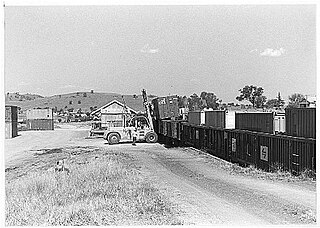
The Barraba branch railway line is a closed railway line in New South Wales, Australia. The line, which was opened on 21 September 1908, ran for 99 kilometres (62 mi) north along the Manilla valley to the town of Barraba from the Main North railway line at West Tamworth.

<span class="mw-page-title-main">Snowy Monaro Regional Council</span> Local government area in New South Wales, Australia

The Snowy Monaro Regional Council is a local government area located in the Snowy Mountains and Monaro regions of New South Wales, Australia. The council was formed on 12 May 2016 through a forced merger of the Bombala, Cooma-Monaro and Snowy River shires.

<span class="mw-page-title-main">Dubbo Regional Council</span> Local government area in New South Wales, Australia

The Dubbo Regional Council is a local government area located in the Central West and Orana regions of New South Wales, Australia. The council was formed on 12 May 2016 through a merger of the City of Dubbo and Wellington Council as part of a widespread council amalgamation program. It was initially named Western Plains Regional Council for almost four months, and its name was changed to Dubbo Regional Council on 7 September 2016.

The Manilla railway underbridges are two heritage-listed railway bridges located on the Tamworth-Barraba railway line in the town of Manilla in the Tamworth Regional Council local government area of New South Wales, Australia. The underbridges are owned by Transport Asset Holding Entity, an agency of the Government of New South Wales. The two sites were added to the New South Wales State Heritage Register on 2 April 1999.

References

  1. 1 2 3 4 5 Australian Bureau of Statistics (28 June 2022). "Tamworth Regional". 2021 Census QuickStats. Retrieved 5 April 2024. OOjs UI icon edit-ltr-progressive.svg
  2. "Tamworth Regional Council". data.nsw.gov.au. Archived from the original on 22 July 2024. Retrieved 23 July 2024. Tamworth Regional Council (TRC) was established in March 2004, amalgamating the northern NSW shires of Barraba, Manilla, Nundle and Parry and the city of Tamworth. It is one of the biggest councils in inland NSW, with a population of over 58,000 spread over an area three times as large as the Sydney basin at 9884.2 sq Km.
  3. "Welcome to Tamworth Regional Council Community Profile". Australian Bureau of Statistics. Archived from the original on 23 July 2024. Retrieved 23 July 2024 via Informed Decisions.
  4. "Council Overview - Tamworth Regional Council". www.tamworth.nsw.gov.au. Archived from the original on 21 February 2011.
  5. "The Legislative Assembly District of Tamworth". NSW Electoral Commission . 11 April 2024. Retrieved 23 July 2024.{{cite web}}: CS1 maint: url-status (link)
  6. "Moonby House". New South Wales State Heritage Register . Department of Planning & Environment. H00061. Retrieved 18 May 2018. CC BY icon.svg Text is licensed by State of New South Wales (Department of Planning and Environment) under CC-BY 4.0 licence .
  7. "Manilla railway underbridges". New South Wales State Heritage Register . Department of Planning & Environment. H01045. Retrieved 18 May 2018. CC BY icon.svg Text is licensed by State of New South Wales (Department of Planning and Environment) under CC-BY 4.0 licence .
  8. "Tamworth Post Office". New South Wales State Heritage Register . Department of Planning & Environment. H01421. Retrieved 18 May 2018. CC BY icon.svg Text is licensed by State of New South Wales (Department of Planning and Environment) under CC-BY 4.0 licence .
  9. "King George V Avenue of Memorial English Oaks". New South Wales State Heritage Register . Department of Planning & Environment. H01922. Retrieved 18 May 2018. CC BY icon.svg Text is licensed by State of New South Wales (Department of Planning and Environment) under CC-BY 4.0 licence .
  10. "Tamworth Railway Station, yard group and movable relics". New South Wales State Heritage Register . Department of Planning & Environment. H01260. Retrieved 18 May 2018. CC BY icon.svg Text is licensed by State of New South Wales (Department of Planning and Environment) under CC-BY 4.0 licence .
  11. "Tamworth rail bridge over Peel River". New South Wales State Heritage Register . Department of Planning & Environment. H01058. Retrieved 18 May 2018. CC BY icon.svg Text is licensed by State of New South Wales (Department of Planning and Environment) under CC-BY 4.0 licence .
  12. "Dominican Roman Catholic Convent". New South Wales State Heritage Register . Department of Planning & Environment. H00122. Retrieved 18 May 2018. CC BY icon.svg Text is licensed by State of New South Wales (Department of Planning and Environment) under CC-BY 4.0 licence .
  13. "Tamworth Peel Barracks". New South Wales State Heritage Register . Department of Planning & Environment. H00550. Retrieved 18 May 2018. CC BY icon.svg Text is licensed by State of New South Wales (Department of Planning and Environment) under CC-BY 4.0 licence .
  14. 1 2 Australian Bureau of Statistics (27 June 2017). "Tamworth Regional (A)". 2016 Census QuickStats. Retrieved 23 November 2017. OOjs UI icon edit-ltr-progressive.svg
  15. Australian Bureau of Statistics (25 October 2007). "Tamworth Regional (A)". 2006 Census QuickStats. Retrieved 24 January 2015.
  16. Australian Bureau of Statistics (31 October 2012). "Tamworth Regional (A)". 2011 Census QuickStats. Retrieved 23 November 2017. OOjs UI icon edit-ltr-progressive.svg
  17. 1 2 "Tamworth Regional Councillor Election". NSW Electoral Commission . 22 December 2021. Archived from the original on 23 July 2024. Retrieved 23 July 2024. The following candidates were declared elected on 22 December 2021: Bede BURKE Russell WEBB (IND) Mark RODDA (IND) Marc SUTHERLAND (IND) Phil BETTS (IND) Helen TICKLE (IND) Brooke SOUTHWELL (IND) Stephen MEARS (ALP) Judy COATES
  18. 1 2 "Mayor and Councillors". Peel Street Tamworth NSW: Tamworth Regional Council. Archived from the original on 23 July 2024.
  19. "DANIEL GILLETT". New South Wales Electoral Commission. 16 August 2024. Archived from the original on 19 August 2024. Retrieved 19 August 2024.
  20. "HEIDI WILLIAMSON". New South Wales Electoral Commission. 16 August 2024. Archived from the original on 19 August 2024. Retrieved 19 August 2024.
  21. "BEDE BURKE". New South Wales Electoral Commission. 16 August 2024. Archived from the original on 19 August 2024. Retrieved 19 August 2024.