Walgett Shire

Last updated

Walgett Shire
New South Wales
Walgett LGA NSW.png
Location in New South Wales
Coordinates 30°01′S148°07′E / 30.017°S 148.117°E / -30.017; 148.117
Population
 • Density0.273415/km2 (0.70814/sq mi)
Established7 March 1906 (1906-03-07)
Area22,336 km2 (8,624.0 sq mi)
MayorJane Keir (Unaligned)
Council seat Walgett
Region Orana
State electorate(s) Barwon
Federal division(s) Parkes
Walgett Shire Council Logo.jpg
Website Walgett Shire
LGAs around Walgett Shire:
Balonne (Qld) Balonne (Qld) Balonne (Qld)
Brewarrina Walgett Shire Moree Plains
Warren Coonamble Narrabri

Walgett Shire is a local government area in the Orana region of New South Wales, Australia. The northern boundary of the Shire is located adjacent to the border between New South Wales and Queensland. The town of Walgett is located on the Namoi River, nearby to its junction with the Barwon River and at the junction of the Kamilaroi Highway and the Castlereagh Highway.

Contents

The Shire is divided between the agricultural areas (producing wool, cattle, wheat and cotton), which are near the Barwon and Namoi rivers or south-east of the Barwon River, and the outback country north-west of the Barwon River, including the black opal mining and fossicking town of Lightning Ridge. Prior to 1957, when Lightning Ridge was established as a significant settlement, the outback country was part of the Western Division.

The mayor of Walgett Shire Council is Jane Keir who is unaligned with any political party. [3]

Towns and villages

Walgett Shire includes Walgett, Lightning Ridge, Collarenebri, Pokataroo, Rowena, Burren Junction, Cryon, Cumborah, Glengarry and Carinda. Come By Chance was established in 1840, before all of the above towns and villages.

Heritage listings

Walgett Shire has a number of heritage-listed sites, including:

Demographics

According to the Australian Bureau of Statistics during 2003–04 there: [5]

Selected historical census data for Walgett Shire local government area
Census year2011 [6] 2016 [1]
PopulationEstimated residents on census night 6,454Decrease2.svg 6,107
LGA rank in terms of size within New South Wales 106thDecrease2.svg 107th
% of New South Wales population
% of Australian population
Cultural and language diversity
Ancestry,
top responses
English
Australian
Italian
Chinese
Irish
Language,
top responses
(other than English)
Italian
Mandarin
Cantonese
Korean
Greek
Religious affiliation
Religious affiliation,
top responses
Catholic
No religion
Anglican
Eastern Orthodox
Buddhism
Median weekly incomes
Personal income Median weekly personal incomeA$
% of Australian median income
Family incomeMedian weekly family income
% of Australian median income
Household incomeMedian weekly household income
% of Australian median income

Council

Walgett Shire Council Walgett Shire Council Offices.jpg
Walgett Shire Council

Between 2004 and 2008, the council was controlled by an Administrator, Vic Smith, [7] appointed by the New South Wales Minister for Local Government. The previous Walgett Shire Council was split between factions representing Lightning Ridge and the rest of the Shire and apparently became unworkable as a result. In 2004, a public inquiry investigated the dispute, among other things, under the Local Government Act, 1993 (NSW). Other matters investigated included poor administration, failure to properly inform councillors in relation to some matters, apparently illegal walkouts by some Councilors to frustrate votes and, in particular, events surrounding a failed project to build a community centre in Lightning Ridge. [8]

Current composition and election method

Walgett Shire Council is composed of nine councillors elected proportionally as a single ward. All councillors are elected for a fixed four-year term of office. The mayor is elected by the councillors at the first meeting of the council. The most recent election was held on 22 December 2021, and the makeup of the council is as follows: [9]

PartyCouncillors
  Unaligned 9
Total9

The current Council, elected in 2021, in order of election, is: [9]

CouncillorPartyNotes
Jane Keir Unaligned
Ian Woodcock Unaligned
Daniel Walford Unaligned
Alf Seaton Unaligned
Jasen Ramien UnalignedMayor
Greg Rummery Unaligned
Michael Cooke Unaligned
Sue Currey Unaligned
Colin Hundy UnalignedDeputy Mayor

Related Research Articles

<span class="mw-page-title-main">Namoi River</span> River in New South Wales, Australia

The Namoi River, a major perennial river that is part of the Barwon catchment of the Murray–Darling basin, is located in the Northern Tablelands and North West Slopes districts of New South Wales, Australia.

<span class="mw-page-title-main">Barwon River (New South Wales)</span> River in New South Wales, Australia

Barwon River, a perennial river that is part of the Murray–Darling basin, is located in the north-west slopes and Orana regions of New South Wales, Australia.

<span class="mw-page-title-main">Walgett, New South Wales</span> Town in New South Wales, Australia

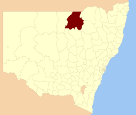
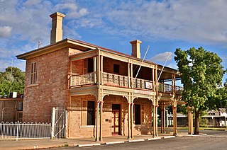
Walgett is a town in northern New South Wales, Australia, and the seat of Walgett Shire. It is near the junctions of the Barwon and Namoi Rivers and the Kamilaroi and Castlereagh Highways. In 2016, Walgett had a population of 2,145.

<span class="mw-page-title-main">Lightning Ridge, New South Wales</span> Town in New South Wales, Australia

Lightning Ridge is a small outback town in north-western New South Wales, Australia. Part of Walgett Shire, Lightning Ridge is situated near the southern border of Queensland, about 6 km (4 mi) east of the Castlereagh Highway. The Lightning Ridge area is a centre of the mining of black opal and other opal gemstones.

<span class="mw-page-title-main">Mungindi</span> Town in New South Wales, Australia

Mungindi is a town and locality on the border of New South Wales (NSW) and Queensland, Australia. The town is within Moree Plains Shire in New South Wales. Within Queensland, the locality is split between the Shire of Balonne and the Goondiwindi Region with the town in the Shire of Balonne. It possesses a New South Wales postcode. Mungindi sits on the Carnarvon Highway and straddles the Barwon River which is the border between New South Wales and Queensland. At the 2016 census, Mungindi had a population of 601 on the New South Wales side, while the population on the Queensland side was 146.

<span class="mw-page-title-main">Collarenebri</span> Town in New South Wales, Australia

Collarenebri is a town in north western New South Wales, Australia. The town is in the Walgett Shire Local Government Area and is situated on the Barwon River approximately 75 kilometres (47 mi) northeast of Walgett and south west of Mungindi on the Gwydir Highway. It is 16 km (9.9 mi) from Pokataroo which was the nearest railway town prior to closure of the rail service there. The town is 150 metres (490 ft) above sea level. Collarenebri is one of three towns ending in 'BRI' in Northern New South Wales.

<span class="mw-page-title-main">Shire of Balonne</span> Local government area in Queensland, Australia

The Shire of Balonne is a local government area in South West Queensland, Australia, over 500 kilometres (310 mi) from the state capital, Brisbane. It covers an area of 31,104 square kilometres (12,009.3 sq mi), and has existed as a local government entity since 1879. It is headquartered in its main town, St George.

<span class="mw-page-title-main">Bogan Shire</span> Local government area in New South Wales, Australia

Bogan Shire is a local government area in the Orana region of New South Wales, Australia. The Shire is located adjacent to the Mitchell and Barrier highways and its only significant town is Nyngan.

<span class="mw-page-title-main">Central Darling Shire</span> Local government area in New South Wales, Australia

Central Darling Shire is a local government area in the Far West region of New South Wales, Australia. The Shire is located adjacent to the Barrier Highway. Central Darling Shire was constituted in 1959 and at 53,511 square kilometres (20,661 sq mi), it is the largest incorporated local government area in New South Wales.

The Group 15 Rugby League, now known as Barwon Darling Rugby League Cup is a rugby league competition in Far North West NSW.

<span class="mw-page-title-main">Narrabri Shire</span> Local government area in New South Wales, Australia

Narrabri Shire is a local government area in the North West Slopes region of New South Wales, Australia. The Shire is located adjacent to the Namoi River and the Newell and Kamilaroi Highways.

<span class="mw-page-title-main">Walcha Shire</span> Local government area in New South Wales, Australia

Walcha Shire is a local government area located in the New England region of New South Wales, Australia. The Shire is situated adjacent to the junction of the Oxley Highway and Thunderbolts Way and is 20 kilometres (12 mi) east of the Main North railway line passing through Walcha Road. The shire was formed on 1 June 1955 through the amalgamation of Apsley Shire and the Municipality of Walcha.

<span class="mw-page-title-main">Uralla Shire</span> Local government area in New South Wales, Australia

Uralla Shire is a local government area located in the New England region of New South Wales, Australia. The New England Highway passes through the Shire.

<span class="mw-page-title-main">Brewarrina Shire</span> Local government area in New South Wales, Australia

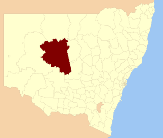
Brewarrina Shire is a local government area in the Orana region of New South Wales, Australia. The Shire is located adjacent to the Darling River, which is known as the Barwon River upstream from Bourke; and located adjacent to the Kamilaroi Highway. The northern boundary of the Shire is located adjacent to the border between New South Wales and Queensland. The Shire is a wool and cotton growing area.

<span class="mw-page-title-main">Bourke Shire</span> Local government area in New South Wales, Australia

Bourke Shire is a local government area in the Orana region of New South Wales, Australia. The Shire is located adjacent to the Darling River, which is known as the Barwon River upstream from Bourke; and located adjacent to the Mitchell Highway. The northern boundary of the Shire is located adjacent to the border between New South Wales and Queensland. The shire is a wool and beef producing area.

<span class="mw-page-title-main">Cobar Shire</span> Local government area in New South Wales, Australia

Cobar Shire is a local government area in the Orana region of New South Wales, Australia. The Shire is located in an outback area that is centred around the mining town of Cobar. The Shire is traversed by the Barrier Highway and the Kidman Way. With a total area of 44,065 square kilometres (17,014 sq mi), about two-thirds the size of Tasmania, Cobar Shire is larger than Denmark and 99 other countries and self-governing territories, but its population is under 5000.

<span class="mw-page-title-main">Gunnedah Shire</span> Local government area in New South Wales, Australia

Gunnedah Shire is a local government area in the North West Slopes region of New South Wales, Australia. The Shire is located adjacent to the Liverpool Plains in the Namoi River valley and is traversed by the Oxley Highway and the Kamilaroi Highway.

<span class="mw-page-title-main">Burren Junction</span> Town in New South Wales, Australia

Burren Junction is a New South Wales village 51 km west of Wee Waa, on the Kamilaroi Highway to Walgett. The name is from the local Aboriginal word for boomerang or 'big creek'. Burren Junction grew from a railway encampment which came from the extension of the north-western rail line in 1902. Burren Junction Post Office opened on 16 May 1904.

<span class="mw-page-title-main">Moonie River</span> River in Queensland and New South Wales, Australia

The Moonie River (Mooni River) is a river in Shire of Balonne, Queensland and Walgett Shire, New South Wales, both in Australia. It is a perennial river of the Barwon catchment within the Murray–Darling basin.

<span class="mw-page-title-main">Angledool</span> Town in New South Wales, Australia

Angledool is a locality in upper western New South Wales near the southern border of Queensland, one kilometre east of the Castlereagh Highway and approximately 45 kilometres north of Lightning Ridge. At the 2016 census, Angledool had a population of 58 people.

References

  1. 1 2 Australian Bureau of Statistics (27 June 2017). "Walgett (A)". 2016 Census QuickStats. Retrieved 7 July 2017. OOjs UI icon edit-ltr-progressive.svg
  2. "3218.0 – Regional Population Growth, Australia, 2017–18". Australian Bureau of Statistics. 27 March 2019. Archived from the original on 27 March 2019. Estimated resident population (ERP) at 30 June 2018.
  3. "Profiles" (PDF). Walgett shire Council. Archived (PDF) from the original on 24 March 2019. Retrieved 21 April 2019.
  4. "Collarenebri Aboriginal Cemetery". New South Wales State Heritage Register . Department of Planning & Environment. H01934. Retrieved 18 May 2018. CC BY icon.svg Text is licensed by State of New South Wales (Department of Planning and Environment) under CC-BY 4.0 licence .
  5. "Regional Wage and Salary Earner Statistics, Australia (catalogue no.: 5673.055.003)". Australian Bureau of Statistics. Archived from the original on 29 June 2011. Retrieved 11 March 2007.
  6. Australian Bureau of Statistics (31 October 2012). "Walgett (A)". 2011 Census QuickStats. Retrieved 23 October 2012. OOjs UI icon edit-ltr-progressive.svg
  7. "Local Government Directory". Division of Local Government. June 2004. Archived from the original on 13 December 2006. Retrieved 14 November 2006.
  8. Bulford, Robert (June 2004). Walgett Shire Council Public Enquiry (PDF). Division of Local Government. p. 89. ISBN   1-920766-10-3. Archived from the original (PDF) on 6 September 2006.
  9. 1 2 "Walgett Shire Council: Summary of First Preference Votes for each Candidate". Local Government Elections 2016. Electoral Commission of New South Wales. 19 September 2016. Archived from the original on 4 November 2016.

Commons-logo.svg Media related to Walgett Shire at Wikimedia Commons