Weddin Shire

Last updated

Weddin Shire
New South Wales
Weddin LGA NSW.png
Location in New South Wales
Coordinates 33°54′S148°09′E / 33.900°S 148.150°E / -33.900; 148.150
Population
 • Density1.0745/km2 (2.783/sq mi)
Area3,410 km2 (1,316.6 sq mi)
MayorCraig Bembrick (Unaligned)
Council seat Grenfell [3]
Region Central West
State electorate(s) Cootamundra
Federal division(s) Riverina
Weddin Shire Logo.png
Website Weddin Shire
LGAs around Weddin Shire:
Lachlan Forbes Cabonne
Bland Weddin Shire Cowra
Temora Hilltops Hilltops

Weddin Shire is a local government area in the Central West region of New South Wales, Australia. The shire's major town is Grenfell and it also includes the small towns of Caragabal, Greenethorpe and Quandialla.

Contents

The mayor of Weddin Shire Council is Cr Craig Bembrick, who is unaligned with any political party.

Demographics

Selected historical census data for Weddin Shire local government area
Census year2001 [4] 2006 [5] 2011 [6] 2016 [1]
PopulationEstimated residents on census night 3,653Decrease2.svg 3,641Increase2.svg 3,665Decrease2.svg 3,664
LGA rank in terms of size within New South Wales 119thIncrease2.svg 118th
% of New South Wales population0.06%Steady2.svg 0.06%Decrease2.svg 0.05%Steady2.svg 0.05%
% of Australian population0.02%Steady2.svg 0.02%Steady2.svg 0.02%Steady2.svg 0.02%
Cultural and language diversity
Ancestry,
top responses
Australian 36.2%Decrease2.svg 35.3%
English 33.7%Decrease2.svg 33.2%
Irish 9.9%Decrease2.svg 8.7%
Scottish 8.4%Decrease2.svg 8.3%
German 2.6%Decrease2.svg 2.4%
Language,
top responses
(other than English)
Cantonese 0.1%Decrease2.svg n/cIncrease2.svg 0.1%Increase2.svg 0.3%
Tagalog n/cSteady2.svg n/cSteady2.svg n/cIncrease2.svg 0.1%
Filipino n/cSteady2.svg n/cIncrease2.svg 0.1%Steady2.svg 0.1%
French n/cSteady2.svg n/cSteady2.svg n/cIncrease2.svg 0.1%
Greek 0.1%Steady2.svg 0.1%Steady2.svg 0.1%Steady2.svg 0.1%
Religious affiliation
Religious affiliation,
top responses
Anglican 32.2%Decrease2.svg 31.3%Decrease2.svg 30.6%Decrease2.svg 26.7%
Catholic 27.7%Decrease2.svg 27.0%Decrease2.svg 26.4%Decrease2.svg 24.1%
No Religion, so described6.8%Increase2.svg 8.1%Increase2.svg 12.9%Increase2.svg 18.5%
Not statedn/cSteady2.svg n/cSteady2.svg n/cIncrease2.svg 10.3%
Uniting Church 9.4%Steady2.svg 9.4%Decrease2.svg 8.9%Decrease2.svg 8.0%
Median weekly incomes
Personal incomeMedian weekly personal incomeA$330A$383A$492
% of Australian median income70.8%Decrease2.svg 66.4%Increase2.svg 74.3%
Family incomeMedian weekly family incomeA$775A$874A$1,193
% of Australian median income66.2%Decrease2.svg 59.0%Increase2.svg 68.8%
Household income Median weekly household incomeA$602A$717A$904
% of Australian median income58.6%Decrease2.svg 58.1%Increase2.svg 62.9%

Council

The Weddin Shire Council Chambers, in Grenfell. Grenfell Weddin Shire Council Offices.JPG
The Weddin Shire Council Chambers, in Grenfell.

Current composition and election method

Weddin Shire Council is composed of nine councillors elected proportionally as a single ward. All councillors are elected for a fixed four-year term of office. [7]

Election results

2024

2024 New South Wales local elections: Weddin [8]
PartyCandidateVotes%±%
Independent Gordon Gam
Independent Phillip Moore
Independent Colleen Gorman
Independent Labor John Niven
Independent Warwick Frame
Independent Jeanne Montgomery
Independent Julie Gilmore
Independent Simon Rolls
Independent Michael Neill
Independent Glenda Howell
Independent Wezley Makin
Independent Chad White
Independent Michelle Cook
Independent Paul Best
Independent Jan Partlett
Total formal votes
Informal votes
Turnout

Heritage listings

Weddin Shire has a number of heritage-listed sites, including:

Related Research Articles

<span class="mw-page-title-main">Ku-ring-gai Council</span> Local government area in New South Wales, Australia

Ku-ring-gai Council is a local government area in Northern Sydney, in the state of New South Wales, Australia. The area is named after a fictional Aboriginal language group.

<span class="mw-page-title-main">Upper Hunter Shire</span> Local government area in New South Wales, Australia

The Upper Hunter Shire is a local government area in the Upper Hunter Valley of New South Wales, Australia. The Shire was formed in May 2004 from the Scone Shire and parts of Murrurundi and Merriwa shires.

<span class="mw-page-title-main">Liverpool Plains Shire</span> Local government area in New South Wales, Australia

Liverpool Plains Shire is a local government area located in the North West Slopes region of New South Wales, Australia. The Shire was formed on 17 March 2004 by the amalgamation of Quirindi Shire with parts of Parry, Murrurundi and Gunnedah shires.

<span class="mw-page-title-main">The Hills Shire</span> Local government area in New South Wales, Australia

The Hills Shire is a local government area in the Greater Sydney region of Sydney, New South Wales, Australia. The area is north-west of the Sydney central business district, and encompasses 401 square kilometres (155 sq mi) stretching from the M2 Hills Motorway in the south to Wisemans Ferry on the Hawkesbury River in the north. The Hills Shire had a population of 191,876 as of the 2021 census.

<span class="mw-page-title-main">Hornsby Shire</span> Local government area in New South Wales, Australia

Hornsby Shire is a local government area situated on the Upper North Shore as well as parts of the Hills District, of Sydney in the state of New South Wales, Australia. The shire stretches from the M2 Hills Motorway in the south to the Hawkesbury River town of Wisemans Ferry, some 53 kilometres (33 mi) to the north, making it the largest local government council in the Greater Sydney Metropolitan region by total area. As of the 2016 census the shire had an estimated population of 142,667.

<span class="mw-page-title-main">Warrumbungle Shire</span> Local government area in New South Wales, Australia

The Warrumbungle Shire is a local government area in the central western region of New South Wales, Australia. The Shire is traversed by the Newell Highway. The Warrumbungle mountain range and Warrumbungles National Park are major tourist attractions for the Shire. Its seat is located in Coonabarabran, a town in the southwest.

<span class="mw-page-title-main">City of Blue Mountains</span> Local government area in New South Wales, Australia

The City of Blue Mountains is a local government area of New South Wales, Australia, governed by the Blue Mountains City Council. The city is located in the Blue Mountains, on the Great Dividing Range at the far western fringe of the Greater Sydney area. Major settlements include, Katoomba, Lawson, Springwood and Blaxland.

<span class="mw-page-title-main">Leeton Shire</span> Local government area in New South Wales, Australia

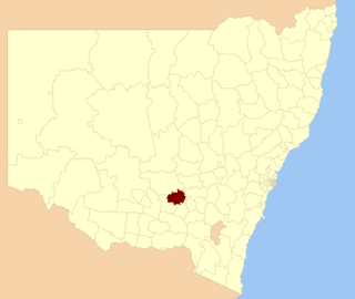
Leeton Shire is a local government area in the Riverina region of New South Wales, Australia. The Shire is located adjacent to the Murrumbidgee River and falls within the Murrumbidgee Irrigation Area.

<span class="mw-page-title-main">Tamworth Regional Council</span> Local government area in New South Wales, Australia

Tamworth Regional Council is a local government area in the New England region of New South Wales, Australia. The area under administration is located adjacent to the New England Highway and the Main North railway line. It was established in March 2004 through the amalgamation of the former City of Tamworth with surrounding shires of Barraba, Manilla, Nundle and Parry.

<span class="mw-page-title-main">Parkes Shire</span> Local government area in New South Wales, Australia

Parkes Shire is a local government area in the Central West region of New South Wales, Australia. The Shire is located adjacent to the Broken Hill railway line and the Newell Highway.

<span class="mw-page-title-main">Muswellbrook Shire</span> Local government area in New South Wales, Australia

Muswellbrook Shire is a local government area in the Upper Hunter region of New South Wales, Australia. The Shire is situated adjacent to the New England Highway and the Hunter railway line.

<span class="mw-page-title-main">Walcha Shire</span> Local government area in New South Wales, Australia

Walcha Shire is a local government area located in the New England region of New South Wales, Australia. The Shire is situated adjacent to the junction of the Oxley Highway and Thunderbolts Way and is 20 kilometres (12 mi) east of the Main North railway line passing through Walcha Road. The shire was formed on 1 June 1955 through the amalgamation of Apsley Shire and the Municipality of Walcha.

<span class="mw-page-title-main">Tenterfield Shire</span> Local government area in New South Wales, Australia

Tenterfield Shire is a local government area located in the New England region of New South Wales, Australia. The Shire is situated adjacent to the New England Highway.

<span class="mw-page-title-main">Temora Shire</span> Local government area in New South Wales, Australia

Temora Shire is a local government area in the Riverina region of New South Wales, Australia. It is on Burley Griffin Way. The Shire was created on 1 January 1981 via the amalgamation of Narraburra Shire and the Municipality of Temora.

<span class="mw-page-title-main">Lockhart Shire</span> Local government area in New South Wales, Australia

Lockhart Shire is a local government area in the Riverina region of New South Wales, Australia. The Shire was created in 1906 and is an agricultural and pastoral area.

<span class="mw-page-title-main">Armidale Regional Council</span> Local government area in New South Wales, Australia

The Armidale Region is a local government area in the New England and Northern Tablelands regions of New South Wales, Australia. This area was formed in 2016 from the merger of the Armidale Dumaresq Shire with the surrounding Guyra Shire.

<span class="mw-page-title-main">Murrumbidgee Council</span> Local government area in New South Wales, Australia

Murrumbidgee Council is a local government area in the Riverina region of New South Wales, Australia. This area was formed in 2016 from the merger of the Murrumbidgee Shire and the Jerilderie Shire.

<span class="mw-page-title-main">Snowy Valleys Council</span> Local government area in New South Wales, Australia

The Snowy Valleys Council is a local government area located in the South West Slopes region of New South Wales, Australia. This area was formed on 12 May 2016 from the merger of the Tumut Shire and Tumbarumba Shire councils.

<span class="mw-page-title-main">Murray River Council</span> Local government area in New South Wales, Australia

The Murray River Council is a local government area in the Riverina region of New South Wales, Australia. This area was formed in 2016 from the merger of Murray Shire with Wakool Shire.

<span class="mw-page-title-main">Dubbo Regional Council</span> Local government area in New South Wales, Australia

The Dubbo Regional Council is a local government area located in the Central West and Orana regions of New South Wales, Australia. The council was formed on 12 May 2016 through a merger of the City of Dubbo and Wellington Council as part of a widespread council amalgamation program. It was initially named Western Plains Regional Council for almost four months, and its name was changed to Dubbo Regional Council on 7 September 2016.

References

  1. 1 2 Australian Bureau of Statistics (27 June 2017). "Weddin (A)". 2016 Census QuickStats. Retrieved 8 December 2017. OOjs UI icon edit-ltr-progressive.svg
  2. "3218.0 – Regional Population Growth, Australia, 2017-18". Australian Bureau of Statistics. 27 March 2019. Retrieved 27 March 2019. Estimated resident population (ERP) at 30 June 2018.
  3. "Weddin Shire Council". Division of Local Government . Retrieved 12 November 2006.
  4. Australian Bureau of Statistics (9 March 2006). "Weddin (A)". 2001 Census QuickStats. Retrieved 26 May 2021. OOjs UI icon edit-ltr-progressive.svg
  5. Australian Bureau of Statistics (25 October 2007). "Weddin (A)". 2006 Census QuickStats. Retrieved 26 May 2021.
  6. Australian Bureau of Statistics (31 October 2012). "Weddin (A)". 2011 Census QuickStats. Retrieved 26 May 2021. OOjs UI icon edit-ltr-progressive.svg
  7. "Weddin Shire Council: Summary of First Preference and Group Votes for each Candidate". Local Government Elections 2016. Electoral Commission of New South Wales. 17 September 2016. Retrieved 5 November 2016.
  8. "JOHN NIVEN". New South Wales Electoral Commission. Archived from the original on 17 August 2024. Retrieved 17 August 2024.
  9. "Iandra Homestead Pastoral Estate". New South Wales State Heritage Register . Department of Planning & Environment. H01723. Retrieved 18 May 2018. CC BY icon.svg Text is licensed by State of New South Wales (Department of Planning and Environment) under CC-BY 4.0 licence .
  10. "Grenfell Railway Station". New South Wales State Heritage Register . Department of Planning & Environment. H01155. Retrieved 18 May 2018. CC BY icon.svg Text is licensed by State of New South Wales (Department of Planning and Environment) under CC-BY 4.0 licence .