Narrandera Shire New South Wales | |||||||||||||||
---|---|---|---|---|---|---|---|---|---|---|---|---|---|---|---|
Coordinates | 34°45′S146°33′E / 34.750°S 146.550°E | ||||||||||||||
Population | |||||||||||||||
• Density | 1.42194/km2 (3.6828/sq mi) | ||||||||||||||
Established | 1 January 1960 | ||||||||||||||
Area | 4,116.2 km2 (1,589.3 sq mi) [3] | ||||||||||||||
Mayor | Cr. Neville Kschenka (Independent) [4] | ||||||||||||||
Council seat | Narrandera [5] | ||||||||||||||
Region | Riverina | ||||||||||||||
State electorate(s) | Cootamundra | ||||||||||||||
Federal division(s) | Farrer [6] | ||||||||||||||
Website | Narrandera Shire | ||||||||||||||
|
Narrandera Shire is a local government area in the Riverina region of south-western New South Wales, Australia. The Shire is located adjacent to the Sturt and Newell Highways.
The present Narrandera Shire was formed on 1 January 1960 by an amalgamation of the previous Narrandera Municipality and Yanko Shire. [7] The first Narrandera Municipality was incorporated on 18 March 1885. Narrandera Shire is a large shire in the geographical centre of the Riverina, with over 1,500 kilometres (930 mi) of roads within its boundaries. [8]
The Shire includes the town of Narrandera and the villages of Grong Grong, Binya and Barellan.
The mayor of Narrandera Shire is Cr. Neville Kschenka, an independent politician. [4]
Narrandera Shire Council is composed of nine councillors elected proportionally as a single ward. All councillors are elected for a fixed four-year term of office. The mayor is elected by the councillors at the first meeting of the council. The most recent election was held on 10 September 2016. The makeup of the council is as follows: [9]
Party | Councillors | |
---|---|---|
Independents and Unaligned | 9 | |
Total | 9 |
The current Council, elected in 2016, in order of election, is: [9]
Councillor | Party | Notes | |
---|---|---|---|
Jenny Clarke | Independent | ||
Tracey Lewis | Independent | ||
Kevin Morris | Independent | ||
Barbara Bryon | Unaligned | ||
David Fahey | Unaligned | Deputy Mayor [4] | |
Neville Kschenka | Independent | Mayor [4] | |
Wesley Hall | Unaligned | ||
Tammy Galvin | Independent | ||
Narelle Payne | Unaligned |
The list of mayors of Narrandera Council (1885–1959) appears below. [10] [11]
Mayor | Term |
---|---|
Robert Heatie Ferrier | 1885 |
Henry Daniel Adams | 1886 |
John Armstrong | 1887 |
James Moulton | 1888 |
Bruce Kennedy | 1988-1989 |
James Bowes | 1889 (February–March) [10] |
John Fleming Willans (1st term) | 1890-1893 |
Michael Cohen | 1894 |
John Fleming Willans (2nd term) | 1894 (July) [10] |
Peter Sullivan | 1895 |
James Armstrong | 1896 |
Lewis S Abrahams | 1897 |
Thomas Henry Elwin (1st term) | 1898 |
Fred Allan Smith (1st term) | 1899-1900 |
James Joseph Quirk | 1901 |
Fred Allan Smith (2nd term) | 1902-1903 |
Ebenezer C H Matthews (1st term) | 1904-1906 |
Thomas Henry Elwin (2nd term) | 1907-1913 |
James Charles Little | 1914 |
Thomas Henry Elwin (3rd term) | 1915-1916 |
Ebernezer C H Matthews (2nd term) | 1916 (November) [10] |
John Anderson McPherson | 1917-1919 |
Robert Henry Hankinson (1st term) | 1920-1921 |
George Norman Dixon | 1922-1923 |
Robert Henry Hankinson (2nd term) | 1924 |
William H Harden | 1924 (April), [10] 1925 |
Robert Henry Hankinson (3rd term) | 1926 |
Samuel Henry Barker | 1927 |
Robert Henry Hankinson (4th term) | 1928-1930 |
Frederick Thelwell Yeoman (1st term) | 1930 (August), [10] 1931 |
Thomas Henry Mancy | 1932-1934 |
Frederick Thelwell Yeoman (2nd term) | 1935 |
Alexander Baird | 1936-1937 |
Frederick Thelwell Yeoman (3rd term) | 1938 |
Ralph E R Skinner | 1939 |
Francis Charles Garner (1st term) | 1940 |
Thomas Gordon (1st term) | 1941 |
Richard Eric Blamey | 1942 |
Thomas Gordon (2nd term) | 1943-1944 |
George F Hepburn | 1945 |
William Joseph Gammage | 1946 |
John Archer Lorimer | 1947 |
Francis Charles Garner (2nd term) | 1948-1950 |
Robert Henry Hankinson (5th term) | 1951 |
William George Armstrong | 1951 (June), [10] 1959 |
The list of mayors of Narrandera Shire Council (1960–present) appears below. [10] [12]
Mayor | Term |
---|---|
Richard Percival Broad | 1960-1961 |
Edward Gilbert Day (1st term) | 1962 |
Archibald Herbert McIntosh | 1963-1965 |
Edward Gilbert Day (2nd term) | 1966-1968 |
Ronald Sydney Stivens | 1969-1973 |
September elections commenced [10] | |
Kenneth Lionel Kiesling (1st term) | 1973-1975 |
Bruce Charles (1st term) | 1975-1977 |
Kenneth Lionel Kiesling (2nd term) | 1977-1979 |
Bruce Charles (2nd term) | 1979-1980 |
Warwick John Heckendorf (1st term) | 1980-1984 |
John Browne Driscoll | 1984-1987 |
Warwick John Heckendorf (2nd term) | 1987-1990 |
Shirley Ann Hocking (1st term) | 1990-1991 |
Desmond Joseph Edwards (1st term) | 1991-1994 |
Shirley Ann Hocking (2nd term) | 1994-1996 |
John Beattie (1st term) | 1996-1999 |
Desmond Joseph Edwards (2nd term) | 1999-2000 |
John Beattie (2nd term) | 2000-2002 |
Desmond Joseph Edwards (3rd term) | 2002-2007 |
John William Sullivan | 2007-2008 |
Graham Eipper (1st term) | 2008-2009 |
Wesley Munro Hall | 2009-2010 |
Graham Eipper (2nd term) | 2010-2011 |
Jennifer Clare Clarke | 2011-2016 |
Neville Raymond Kschenka | 2016–present |
Jerilderie Shire was a local government area in the Riverina region of southern New South Wales, Australia. The Shire was located adjacent to the Newell Highway. The Shire was declared in 1918 after the amalgamation of the former Municipality of Jerilderie and Wunnamurra Shire. It was dissolved in 2016 after its amalgamation with Murrumbidgee Shire to create Murrumbidgee Council
Greater Hume Shire is a local government area in the Riverina region of southern New South Wales, Australia. The Shire was formed in 2004 incorporating Culcairn Shire, the majority of Holbrook Shire and part of Hume Shire. The shire had an estimated population of 10,137 as at 2012.
Leeton Shire is a local government area in the Riverina region of New South Wales, Australia. The Shire is located adjacent to the Murrumbidgee River and falls within the Murrumbidgee Irrigation Area.
Grong Grong is a small town that is located in the Riverina region of New South Wales, Australia. The town is situated on the Newell Highway, 23 kilometres (14 mi) east of Narrandera in the Shire of Narrandera.
Murray Shire was a local government area in the Riverina region of south western New South Wales, Australia. It included the towns of Moama and Mathoura. It was abolished on 12 May 2016 and its area merged with the Wakool Shire to establish the Murray River Council.
Bland Shire is a local government area in the Riverina region of New South Wales, Australia. it covers an area of 8,560 square kilometres (3,310 sq mi). As at the 2016 census the population was 5,995. It is a member of the League of Extraordinary Communities which was established by Dull, Perth and Kinross, Scotland, UK and Boring, Oregon, USA.
The Carrathool Shire is a local government area that borders both the Riverina and Far West regions of New South Wales, Australia. The Shire comprises 18,933 square kilometres (7,310 sq mi) and is located adjacent to the Mid-Western Highway and north of the Sturt Highway.
Wakool Shire was a local government area in the Riverina region of New South Wales, Australia. The Shire was located between the Murray River and the Murrumbidgee River and adjacent to the Sturt Highway. Towns in the Shire are Barham, Moulamein, Tooleybuc, Wakool and Koraleigh.
Berrigan Shire is a local government area in the southern Riverina region of New South Wales, Australia. The Shire lies on the New South Wales State border with Victoria formed by the Murray River. The Shire is adjacent to the Newell and Riverina Highways. The Shire is a mainly agricultural region, with dairying, cattle raising, woolgrowing and cropping the main activities. The vast majority of the Shire is irrigated. Tourism is another major activity, concentrated on the river towns of Tocumwal and Barooga.
Gundagai Shire was a local government area in the Riverina region of New South Wales, Australia. On 12 May 2016, Gundagai Shire was abolished and merged with the neighbouring Cootamundra Shire to establish Cootamundra-Gundagai Regional Council.
Bathurst Regional Council is a local government area in the Central West region of New South Wales, Australia. The area is located adjacent to the Great Western Highway, Mid-Western Highway, Mitchell Highway and the Main Western railway line. At the 2016 census, the Bathurst Region had a population of 41,300.
Forbes Shire is a local government area in the central west region of New South Wales, Australia. The Shire was formed in 1981 from the amalgamation of the Municipality of Forbes and the Shire of Jemalong resulting from the Local Government Areas Amalgamation Act 1980.
Cootamundra Shire was a local government area in the Riverina region of New South Wales, Australia. The Shire was located adjacent to the Olympic Highway, the Burley Griffin Way and the Main South railway line. The Shire included the town of Cootamundra and the small towns of Stockinbingal, Brawlin and Wallendbeen and the locality of Frampton. The Shire was created on 1 April 1975 by the amalgamation of Jindalee Shire and the Municipality of Cootamundra.
The Junee Shire is a local government area in the Riverina region of New South Wales, Australia. The Shire comprises an area of 2,030 square kilometres (780 sq mi) and is located adjacent to the Olympic Highway and the Main South railway line. It was formed on 1 January 1981 from the amalgamation of the Municipality of Junee and Illabo Shire resulting from the Local Government Areas Amalgamation Act 1980.
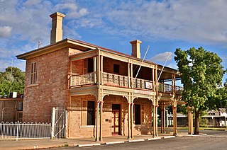
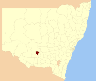
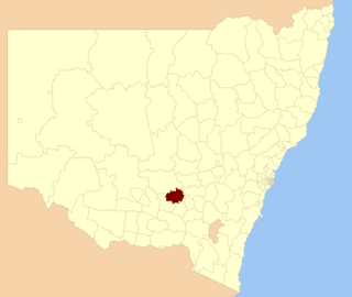
Lockhart Shire is a local government area in the Riverina region of New South Wales, Australia. The Shire was created in 1906 and is an agricultural and pastoral area.
The Hay Shire is a local government area in the Riverina area of south-western New South Wales, Australia. The Shire comprises 11,326 square kilometres (4,373 sq mi) and is located adjacent to the Sturt, Mid-western and Cobb Highways. The area includes the towns of Hay, Booligal and Maude.
Ganmain is a town in the Riverina region of New South Wales, Australia. Ganmain is located around 55 kilometres (34 mi) north west of Wagga Wagga, and 50 kilometres (31 mi) east of Narrandera. Ganmain is in the Coolamon Shire local government area and had a population at the 2016 census of 779.
The Edward River Council is a local government area in the Riverina region of New South Wales, Australia. This area was formed in 2016 from the merger of the Deniliquin Council with the surrounding Conargo Shire.
Murrumbidgee Council is a local government area in the Riverina region of New South Wales, Australia. This area was formed in 2016 from the merger of the Murrumbidgee Shire and the Jerilderie Shire.
Cootamundra–Gundagai Regional Council (CGRC) is a local government area located in the South West Slopes and Riverina regions of New South Wales, Australia. The council was formed on 12 May 2016 through a merger of the Cootamundra and Gundagai shires. Originally named Gundagai Council, the name was changed to Cootamundra–Gundagai Regional Council on 7 September 2016.