Uralla Shire

Last updated

Uralla Shire
New South Wales
Uralla Shire Council chambers.JPG
Council chambers, 2010
Uralla LGA NSW.png
Location in New South Wales
Coordinates 30°39′S151°30′E / 30.650°S 151.500°E / -30.650; 151.500
Population
 • Density1.8724/km2 (4.850/sq mi)
Established1 January 1948 (1948-01-01) [3]
Area3,230 km2 (1,247.1 sq mi)
MayorRobert Bell (Independent)
Council seat Uralla [4]
Region New England
State electorate(s) Northern Tablelands
Federal division(s) New England
Website Uralla Shire
LGAs around Uralla Shire:
Gwydir Inverell Armidale
Tamworth Uralla Shire Armidale
Tamworth Walcha Walcha

Uralla Shire is a local government area located in the New England region of New South Wales, Australia. The New England Highway passes through the Shire.

Contents

The Shire was established on 1 January 1948 as a result of the amalgamation of the Municipality of Uralla with the surrounding Gostwyck Shire. [3] The mayor of Uralla Shire Council is Cr. Robert Bell.

Towns and villages

The towns and villages of Uralla Shire include Uralla, Arding, Bundarra, Yarrowyck, Kingstown, Kentucky, Invergowrie and Wollun.

Heritage listings

The Uralla Shire has a number of heritage-listed sites, including:

Demographics

According to the Australian Bureau of Statistics [13] there:

Incomes

According to the Australian Bureau Statistics [14] during 2003–04, there:

Council

Uralla Shire Council chambers. Uralla Shire Council chambers.JPG
Uralla Shire Council chambers.

Current composition and election method

Uralla Shire Council is composed of nine councillors elected proportionally as three separate wards, each electing three councillors. All councillors are elected for a fixed four-year term of office. The mayor is elected by the councillors at the first meeting of the council. The most recent election was held on 8 September 2012 and the makeup of the council is as follows: [15] [16] [17]

PartyCouncillors
  Independent and Unaligned9
Total9

The current Council, elected in 2012, in order of election by ward, is:

WardCouncillorPartyNotes
Ward A [15]  Bob Crouch Independent Deputy Mayor [18]
 Michael PearceUnalignedMayor [18]
 Mark DustingIndependent
Ward B [16]  Kevin WardUnaligned
 Fred GeldofUnaligned
 Daphne FieldIndependent
Ward C [17]  Isabell StruttIndependent
 Leanne CooperIndependent
 Karen DustingIndependent

At the 2012 local government elections, a referendum was held to directly elect the mayor and reduce the number of wards from three to two, each electing four councillors. The referendum was passed, with 55.96% voting in favour of the resolution. [19] The changes will take place at the next local government elections, due to be held in 2016.

Proposed amalgamation

A 2015 review of local government boundaries recommended that the Armidale Dumaresq Shire and the Guyra Shire councils merge. [20] An alternative proposal, submitted by the Armidale Dumaresq Council on 1 March 2016, was for an amalgamation of the Armidale Dumaresq, Guyra, Uralla and Walcha councils. [21] The outcome of the independent review is expected by mid2016.

Related Research Articles

<span class="mw-page-title-main">Armidale</span> City in New South Wales, Australia

Armidale is a city in the Northern Tablelands, New South Wales, Australia. Armidale had a population of 23,967 as of the 2021 census. It is the administrative centre for the Northern Tablelands region. It is approximately halfway between Sydney and Brisbane at the junction of the New England Highway and Waterfall Way.

<span class="mw-page-title-main">Uralla, New South Wales</span> Town in New South Wales, Australia

Uralla is a town on the Northern Tablelands, New South Wales, Australia. It is located at the intersection of the New England Highway and Thunderbolts Way, 465 kilometres (289 mi) north of Sydney and about 23 kilometres (14 mi) south-west of the city of Armidale. At the 2016 census, the township of Uralla had a population of 2,388 people. According to the 2021 census, the population of Uralla had slightly decreased to 2358.

<span class="mw-page-title-main">Upper Hunter Shire</span> Local government area in New South Wales, Australia

The Upper Hunter Shire is a local government area in the Upper Hunter Valley of New South Wales, Australia. The Shire was formed in May 2004 from the Scone Shire and parts of Murrurundi and Merriwa shires.

<span class="mw-page-title-main">Leeton Shire</span> Local government area in New South Wales, Australia

Leeton Shire is a local government area in the Riverina region of New South Wales, Australia. The Shire is located adjacent to the Murrumbidgee River and falls within the Murrumbidgee Irrigation Area.

<span class="mw-page-title-main">Thunderbolts Way</span> Road in New South Wales, Australia

Thunderbolts Way is a 305-kilometre (190 mi) country road located in the Northern Tablelands region of New South Wales, Australia, linking Inverell via Bundarra, Uralla and Walcha to Gloucester The road is sealed and passes through thickly forested mountain areas with many nearby national parks and nature reserves.

<span class="mw-page-title-main">Tingha, New South Wales</span> Town in New South Wales, Australia

Tingha is a small town on the Northern Tablelands, New South Wales, Australia in Inverell Shire. Formerly part of Armidale Region, on 1 July 2019, responsibility for Tingha was transferred from Armidale Regional Council to Inverell Shire Council. The town is 30 kilometres (19 mi) south of Inverell and 559 kilometres (347 mi) north-north-east of Sydney. Tingha is an Aboriginal word for "flat or level".

<span class="mw-page-title-main">John Horbury Hunt</span> Australian architect

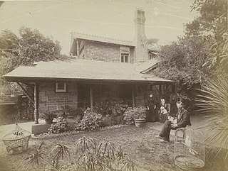
John Horbury Hunt, often referred to as Horbury Hunt, was a Canadian-born Australian architect who worked in Sydney and rural New South Wales from 1863.

<span class="mw-page-title-main">Ben Lomond, New South Wales</span> Town in New South Wales, Australia

Ben Lomond is a village on the Northern Tablelands in the New England region of New South Wales, Australia. The village is situated 6 km off the New England Highway between Armidale and Glen Innes. It was located in the Guyra Shire local government area until that council was amalgamated into the Armidale Regional Council on 12 May 2016, with parts of the surrounding district in Glen Innes Severn Shire and Inverell Shire. It is primarily a farming area, with most of the residents involved in sheep, cattle and grain farming.

<span class="mw-page-title-main">Armidale Dumaresq Shire</span> Former local government area in New South Wales, Australia

The Armidale Dumaresq Council was a local government area in the New England and Northern Tablelands regions of New South Wales, Australia. This area was formed in 2000 from the merger of the original City of Armidale with the surrounding Dumaresq Shire and abolished on 12 May 2016, where the council, together with Guyra Shire, was subsumed into the Armidale Regional Council with immediate effect.

<span class="mw-page-title-main">Muswellbrook Shire</span> Local government area in New South Wales, Australia

Muswellbrook Shire is a local government area in the Upper Hunter region of New South Wales, Australia. The Shire is situated adjacent to the New England Highway and the Hunter railway line.

<span class="mw-page-title-main">Walcha Shire</span> Local government area in New South Wales, Australia

Walcha Shire is a local government area located in the New England region of New South Wales, Australia. The Shire is situated adjacent to the junction of the Oxley Highway and Thunderbolts Way and is 20 kilometres (12 mi) east of the Main North railway line passing through Walcha Road. The shire was formed on 1 June 1955 through the amalgamation of Apsley Shire and the Municipality of Walcha.

<span class="mw-page-title-main">Guyra Shire</span> Former local government area in New South Wales, Australia

Guyra Shire was a local government area located in the New England region of New South Wales, Australia. The shire was abolished on 12 May 2016, where the council merged with the Armidale Dumaresq Shire, was subsumed into the Armidale Regional Council with immediate effect.

<span class="mw-page-title-main">Bundarra, New South Wales</span> Town in New South Wales, Australia

Bundarra is a small town on the Northern Tablelands of New South Wales, Australia. The town is located on Thunderbolts Way and on the banks of the Gwydir River, in the Uralla Shire local government area, 563 kilometres (350 mi) from the state capital, Sydney. At the 2016 census, Bundarra had a population of 394 and the surrounding area had 676 persons.

<span class="mw-page-title-main">Black Mountain, New South Wales</span> Town in New South Wales, Australia

Black Mountain is a village situated between Armidale and Guyra, located on the Northern Tablelands in the New England region of New South Wales, Australia. Situated within Armidale Regional Council, as at the 2016 census, Black Mountain had a population of 310.

<span class="mw-page-title-main">Uralla railway station</span> Railway station in New South Wales, Australia

Uralla railway station is a heritage-listed railway station located on the Main Northern line in the Uralla Shire, New South Wales, Australia. It serves the town of Uralla, and opened on 2 August 1882 when the line was extended from Kootingal. It was the terminus of the line until it was extended to Armidale on 3 February 1883. It is also known as Uralla Railway Station group. The property was added to the New South Wales State Heritage Register on 2 April 1999.

Dumaresq is a town in the Northern Tablelands, New South Wales, Australia. It is located approximately 20 km north-west of Armidale, on Boorolong Road. The local council is Armidale Regional Council, it once belonged to Dumaresq Shire, and then Armidale Dumaresq Shire. The town is located within Sandon County.

<span class="mw-page-title-main">Armidale Regional Council</span> Local government area in New South Wales, Australia

The Armidale Region is a local government area in the New England and Northern Tablelands regions of New South Wales, Australia. This area was formed in 2016 from the merger of the Armidale Dumaresq Shire with the surrounding Guyra Shire.

The Bundarra Police Station and Courthouse is a heritage-listed former police station and courthouse located at Oliver Street, Bundarra, in the Uralla Shire, New South Wales, Australia. It was designed by James Barnet and built from 1869 to 1870 by Alfred Dorrey. The property is owned by Bundarra Community Purposes Reserve Trust. It was added to the New South Wales State Heritage Register on 2 April 1999.

<span class="mw-page-title-main">Captain Thunderbolt's Grave</span> Historic site in New South Wales, Australia

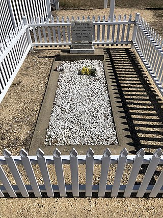
Captain Thunderbolt's Grave is a heritage-listed burial site located at Uralla Square in Uralla, Uralla Shire local government area of New South Wales, Australia. The grave comprises a marble headstone, designed by Mr Callcott, and built in 1914. It is also known as Uralla Old General Cemetery. It is one of a group of historic sites labelled The Captain Thunderbolt Sites for their association with bushranger Captain Thunderbolt, along with Captain Thunderbolt's Rock, Blanch's Royal Oak Inn, and Captain Thunderbolt's Death Site. Collectively, all properties were added to the New South Wales State Heritage Register on 20 July 2012.

<span class="mw-page-title-main">Captain Thunderbolt's Rock</span> Historic site in New South Wales, Australia

Thunderbolt's Rock is a heritage-listed rock and now picnic site and tourist attraction located adjacent to the New England Highway in Uralla, in the Uralla Shire local government area of New South Wales, Australia. It is also known as Split Rock and Big Rock. The property is owned by Uralla Shire Council. It is one of a group of historic sites labelled The Captain Thunderbolt Sites for their association with bushranger Captain Thunderbolt, along with Blanch's Royal Oak Inn, Captain Thunderbolt's Death Site, and Captain Thunderbolt's Grave. Collectively, all properties were added to the New South Wales State Heritage Register on 20 July 2012.

References

  1. Australian Bureau of Statistics (27 June 2017). "Uralla (A)". 2016 Census QuickStats. Retrieved 8 December 2017. OOjs UI icon edit-ltr-progressive.svg
  2. "3218.0 – Regional Population Growth, Australia, 2017–18". Australian Bureau of Statistics. 27 March 2019. Retrieved 27 March 2019. Estimated resident population (ERP) at 30 June 2018.
  3. 1 2 "Local Government Act 1919. Proclamation (2821)". Government Gazette of the State of New South Wales . 5 December 1947. p. 139. Retrieved 14 January 2020 via National Library of Australia.
  4. "Uralla Shire Council". Department of Local Government. Archived from the original on 28 March 2011. Retrieved 17 June 2011.
  5. "Bundarra Police Station & Courthouse". New South Wales State Heritage Register . Department of Planning & Environment. H00229. Retrieved 18 May 2018. CC BY icon.svg Text is licensed by State of New South Wales (Department of Planning and Environment) under CC-BY 4.0 licence .
  6. "The Captain Thunderbolt Sites - Thunderbolt's Death Site". New South Wales State Heritage Register . Department of Planning & Environment. H01889. Retrieved 2 June 2018. CC BY icon.svg Text is licensed by State of New South Wales (Department of Planning and Environment) under CC-BY 4.0 licence .
  7. "New England Brass and Iron Lace Foundry". New South Wales State Heritage Register . Department of Planning & Environment. H01455. Retrieved 18 May 2018. CC BY icon.svg Text is licensed by State of New South Wales (Department of Planning and Environment) under CC-BY 4.0 licence .
  8. "Uralla Railway Station group". New South Wales State Heritage Register . Department of Planning & Environment. H01275. Retrieved 18 May 2018. CC BY icon.svg Text is licensed by State of New South Wales (Department of Planning and Environment) under CC-BY 4.0 licence .
  9. "McCrossins Mill". New South Wales State Heritage Register . Department of Planning & Environment. H00161. Retrieved 18 May 2018. CC BY icon.svg Text is licensed by State of New South Wales (Department of Planning and Environment) under CC-BY 4.0 licence .
  10. "The Captain Thunderbolt Sites - Thunderbolt's Grave". New South Wales State Heritage Register . Department of Planning & Environment. H01889. Retrieved 18 May 2018. CC BY icon.svg Text is licensed by State of New South Wales (Department of Planning and Environment) under CC-BY 4.0 licence .
  11. "The Captain Thunderbolt Sites - Blanch's Royal Oak Inn". New South Wales State Heritage Register . Department of Planning & Environment. H01889. Retrieved 18 May 2018. CC BY icon.svg Text is licensed by State of New South Wales (Department of Planning and Environment) under CC-BY 4.0 licence .
  12. "The Captain Thunderbolt Sites - Thunderbolt's Rock". New South Wales State Heritage Register . Department of Planning & Environment. H01889. Retrieved 18 May 2018. CC BY icon.svg Text is licensed by State of New South Wales (Department of Planning and Environment) under CC-BY 4.0 licence .
  13. "Regional Population Growth, Australia, 2005–06 (catalogue no.: 3218.0)". Australian Bureau of Statistics . Retrieved 12 March 2007.
  14. "Regional Wage and Salary Earner Statistics, Australia (catalogue no.: 5673.055.003)". Australian Bureau of Statistics . Retrieved 11 March 2007.
  15. 1 2 "Uralla Council – A Ward: Summary of First Preference Votes for each Candidate". Local Government Elections 2012. Electoral Commission of New South Wales. 14 September 2012. Retrieved 12 October 2012.
  16. 1 2 "Uralla Council – B Ward: Summary of First Preference Votes for each Candidate". Local Government Elections 2012. Electoral Commission of New South Wales. 14 September 2012. Retrieved 12 October 2012.
  17. 1 2 "Uralla Council – C Ward: Summary of First Preference Votes for each Candidate". Local Government Elections 2012. Electoral Commission of New South Wales. 15 September 2012. Retrieved 12 October 2012.
  18. 1 2 Denman, Elyse (20 September 2012). "New mayor for Uralla Shire Council". Australia: ABC News. Retrieved 12 October 2012.
  19. "Uralla Council – Referendum". Local Government Elections 2012. Electoral Commission of New South Wales. 14 September 2012. Retrieved 12 October 2012.
  20. "Merger proposal: Armidale Dumaresq Council and Guyra Shire Council" (PDF). Government of New South Wales. January 2016. p. 7. Retrieved 18 February 2016.[ permanent dead link ]
  21. Armidale Dumaresq Council (1 March 2016). "Merger proposal: Armidale Dumaresq Council, Guyra Shire Council, Uralla Shire Council and Walcha Council" (PDF). Government of New South Wales . Retrieved 7 March 2016.

Commons-logo.svg Media related to Uralla Shire at Wikimedia Commons