City of Lithgow

Last updated

City of Lithgow
New South Wales
Lithgow LGA NSW.png
Location in New South Wales
Coordinates 33°29′S150°09′E / 33.483°S 150.150°E / -33.483; 150.150
Population
 • Density4.5797/km2 (11.8612/sq mi)
Area4,551 km2 (1,757.2 sq mi)
MayorMaree Statham (Unaligned)
Council seat Lithgow [3]
Region Central West
State electorate(s) Bathurst
Federal division(s)
Lithgow City CouncilLogo.jpg
Website City of Lithgow
LGAs around City of Lithgow:
Mid-Western Singleton Hawkesbury
Bathurst City of Lithgow Blue Mountains
Oberon Oberon Wollondilly

The City of Lithgow is a local government area in the Central West region of New South Wales, Australia. The area is located adjacent to the Great Western Highway and the Main Western railway line.

Contents

The mayor of the City of Lithgow Council is Cr. Maree Statham, who is unaligned with any political party.

Main towns and villages

The council seat is located in the city of Lithgow, the largest regional centre. The area also includes the towns and villages of Bell, Ben Bullen, Bogee, Bowenfels, Capertee, Clarence, Cullen Bullen, Dargan, Glen Alice, Glen Davis, Hampton, Hartley, Hartley Vale, Little Hartley, Marrangaroo, Meadow Flat, Newnes, Portland, Rydal, Sodwalls, Tarana, and Wallerawang.

Demographics

According to the Australian Bureau of Statistics on 2006 census night there were: [4]

Council

Current composition and election method

Lithgow City Council is composed of nine councillors elected proportionally as a single ward. All councillors are elected for a fixed four-year term of office. The mayor is elected by the councillors at the first meeting of the council. The most recent election was held on 4 December 2021.

PartyCouncillors
  Independent and Unaligned9
Total9

Election results

2021

Elected councillorParty
 Maree StrathamTeam Maree
 Col O'ConnorTeam Maree
 Stuart McGhieTeam Maree
 Almudena BryceTeam Maree
 Darryl GoodwinGood for Council
 Deanna GoodsellGood for Council
 Cass ColemanCass Coleman
 Eric MahonyCass Coleman
 Stephen LesslieIndependent
2021 New South Wales local elections: Lithgow [5] [6]
PartyCandidateVotes%±%
Team Maree5,50242.1
Good for Council2,49619.1
Cass Coleman Community Team 2,14716.4
Independent 1,66512.7
Ring's Independent Lithgow6334.8
Lithgow First6184.7
Total formal votes13,06195.4
Informal votes6364.6
Turnout 13,69786.4

Heritage listings

The City of Lithgow has a number of heritage-listed sites, including:

Related Research Articles

<span class="mw-page-title-main">Lithgow, New South Wales</span> Town in New South Wales, Australia

Lithgow is a town in the Central Tablelands of New South Wales, Australia and is the administrative centre of the City of Lithgow local government area. It is located in a mountain valley named Lithgow's Valley by John Oxley in honour of William Lithgow, the first Auditor-General of New South Wales.

<span class="mw-page-title-main">Warrumbungle Shire</span> Local government area in New South Wales, Australia

The Warrumbungle Shire is a local government area in the central western region of New South Wales, Australia. The Shire is traversed by the Newell Highway. The Warrumbungle mountain range and Warrumbungles National Park are major tourist attractions for the Shire. Its capital is Coonabarabran, a city in the southwest.

<span class="mw-page-title-main">City of Blue Mountains</span> Local government area in New South Wales, Australia

The City of Blue Mountains is a local government area of New South Wales, Australia, governed by the Blue Mountains City Council. The city is located in the Blue Mountains, on the Great Dividing Range at the far western fringe of the Greater Sydney area.

<span class="mw-page-title-main">Hartley, New South Wales</span> Town in New South Wales, Australia

Hartley is a historical village in the Central West region of New South Wales, Australia, within the City of Lithgow local government area, located approximately 127 kilometres (79 mi) west of Sydney. Hartley is located below the western escarpment of the Blue Mountains.

<span class="mw-page-title-main">Bowenfels, New South Wales</span> Town in New South Wales, Australia

Bowenfels is a small town on the western outskirts of Lithgow, New South Wales, Australia.

<span class="mw-page-title-main">Bowenfels railway station</span> Former railway station in New South Wales, Australia

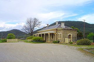
The Bowenfels railway station is a heritage-listed disused railway station and now visitor's centre and restaurant located on the Main Western line in Bowenfels, City of Lithgow, New South Wales, Australia. It was designed by John Clifton and the New South Wales Government Railways and built from 1869 to 1869 by G. Watsford, NSW Government Railway. It is also known as the Bowenfels Railway Station and Stationmaster's House and Old Station Masters Residence and Station. It was added to the New South Wales State Heritage Register on 2 April 1999.

Rydal is a small rural village in New South Wales, Australia.

<span class="mw-page-title-main">Lithgow Zig Zag</span> Railway line in New South Wales, Australia

The Lithgow Zig Zag is a heritage-listed former zig zag railway line built near Lithgow on the Great Western Line of New South Wales in Australia. The zig zag line operated between 1869 and 1910, to overcome an otherwise insurmountable climb and descent on the western side of the Blue Mountains. It was designed by John Whitton and built from 1863 to 1869 by Patrick Higgins as contractor. It is also known as the Great Zig Zag Railway and Reserves and Zig Zag Railway. The property is owned by Department of Planning and Infrastructure. It was added to the New South Wales State Heritage Register on 2 April 1999.

<span class="mw-page-title-main">Wallerawang</span> Town in New South Wales, Australia

Wallerawang is a small township in the Central Tablelands of New South Wales, Australia. It is located approximately 14 kilometres (8.7 mi) northwest of Lithgow adjacent to the Great Western Highway. It is also located on the Main Western railway line at the junction of the Gwabegar line. The name is also applied to the surrounding area for postal and statistical purposes.

South Bowenfels is a suburb in the City of Lithgow, New South Wales, Australia.

<span class="mw-page-title-main">Rydal railway station</span> Railway station in New South Wales, Australia

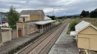
Rydal railway station is a heritage-listed railway station located on the Main Western line in Rydal, City of Lithgow, New South Wales, Australia. It is also known as Rydal Railway Station group. The property was added to the New South Wales State Heritage Register on 2 April 1999.

<span class="mw-page-title-main">Wallerawang railway station</span> Historic site in New South Wales, Australia

Wallerawang railway station is a heritage-listed disused railway station located on the Main Western line in Wallerawang, City of Lithgow, New South Wales, Australia. It is also known as Wallerawang Railway Station and yard group. The property was added to the New South Wales State Heritage Register on 2 April 1999.

George McGarvie Donald was an Australian politician and stonemason.

<span class="mw-page-title-main">Lithgow Underbridge</span> Bridge in New South Wales, Australia

The Lithgow Underbridge is a heritage-listed railway underbridge that carries the Main West Line over James Street, in Lithgow, in the City of Lithgow local government area of New South Wales, Australia. The bridge is located approximately 156 kilometres (97 mi) from Central railway station. The bridge was designed by John Whitton as the Engineer-in-Chief for Railways and was built in 1869 by contractor, P. Higgins. It is also known as Lithgow Underbridge. The property is owned by Transport Asset Holding Entity, an agency of the Government of New South Wales. It was added to the New South Wales State Heritage Register on 30 August 2013.

<span class="mw-page-title-main">Marrangaroo railway viaduct</span> Heritage listed railway viaduct in New South Wales, Australia

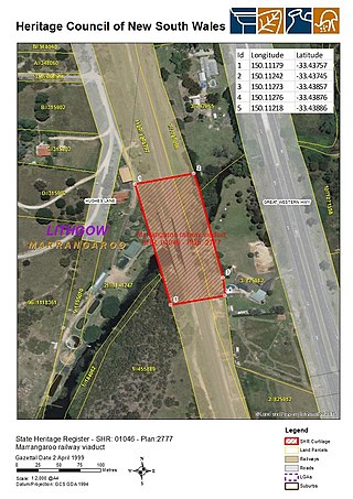
The Marrangaroo railway viaduct is a heritage-listed railway viaduct that carries the Main Western Line across Marrangaroo Creek at Marrangaroo in the City of Lithgow local government area of New South Wales, Australia. The property added to the New South Wales State Heritage Register on 2 April 1999.

<span class="mw-page-title-main">St John the Evangelist Church, Wallerawang</span> Church in New South Wales, Australia

St John the Evangelist Church is a heritage-listed Presbyterian church located at Main Street, Wallerawang, City of Lithgow, New South Wales, Australia. It was designed by Edmund Blacket and Blacket and Sons, and built from 1880 to 1881 by George Donald. It is also known as the Church of St. John the Evangelist. It was added to the New South Wales State Heritage Register on 10 September 2004.

<span class="mw-page-title-main">Bowenfels rail viaducts</span> Bridge in New South Wales, Australia

The Bowenfels rail viaducts are a series of heritage-listed railway viaducts and railway bridges over Farmers Creek on the Main Western Line in Bowenfels, City of Lithgow, New South Wales, Australia. It was designed in two stages, by John Whitton as the Engineer-in-Chief for Railways, in 1870; and by engineering staff of New South Wales Government Railways in 1921; and was built from 1870 to 1921. It is also known as Farmers Creek viaducts. The property is owned by Transport Asset Holding Entity, an agency of the Government of New South Wales. It was added to the New South Wales State Heritage Register on 2 April 1999. The viaduct are located approximately 159 kilometres (99 mi) west of Central railway station.

<span class="mw-page-title-main">Coxs River railway bridges, Wallerawang</span> Heritage listed railway bridges in New South Wales

The Coxs River railway bridges are two heritage-listed railway bridges that carry the Main Western Line over the Coxs River at Wallerawang, City of Lithgow, New South Wales, Australia. The bridges were designed by engineering staff of the New South Wales Government Railways and built in 1870 by day labour. The property is owned by Transport Asset Holding Entity, an agency of the Government of New South Wales. It was added to the New South Wales State Heritage Register on 2 April 1999.

<span class="mw-page-title-main">Rydal rail underbridges</span> Bridge in New South Wales, Australia

The Rydal rail underbridges are a series of heritage-listed railway underbridges and viaducts that carry the Main Western line over Solitary Creek at Rydal, in the City of Lithgow local government area of New South Wales, Australia. The property is owned by Transport Asset Holding Entity, an agency of the Government of New South Wales. It was added to the New South Wales State Heritage Register on 2 April 1999.

<span class="mw-page-title-main">Ben Bullen railway station</span> Railway station in New South Wales, Australia

The Ben Bullen railway station is a heritage-listed railway station on the Wallerawang–Gwabegar railway line at Ben Bullen, City of Lithgow, New South Wales, Australia. It is also known as Ben Bullen Railway Station group. The property was added to the New South Wales State Heritage Register on 2 April 1999.

References

  1. Australian Bureau of Statistics (28 June 2022). "Lithgow (C)". 2021 Census QuickStats. Retrieved 6 February 2023. OOjs UI icon edit-ltr-progressive.svg
  2. "3218.0 – Regional Population Growth, Australia, 2017–18". Australian Bureau of Statistics. 27 March 2019. Archived from the original on 27 March 2019. Retrieved 27 March 2019. Estimated resident population (ERP) at 30 June 2018.
  3. "City of Lithgow Council". Division of Local Government. Archived from the original on 10 September 2007. Retrieved 15 November 2006.
  4. "Regional Population Growth, Australia, 2005–06 (catalogue no.: 3218.0)". Australian Bureau of Statistics. Archived from the original on 29 June 2011. Retrieved 12 March 2007.
  5. "City of Lithgow". ABC News.
  6. "Coleman fighting to give families voice". Western Advocate.
  7. "Ben Bullen Railway Station group". New South Wales State Heritage Register . Department of Planning & Environment. H01082. Retrieved 18 May 2018. CC BY icon.svg Text is licensed by State of New South Wales (Department of Planning and Environment) under CC-BY 4.0 licence .
  8. "Fernhill". New South Wales State Heritage Register . Department of Planning & Environment. H00225. Retrieved 18 May 2018. CC BY icon.svg Text is licensed by State of New South Wales (Department of Planning and Environment) under CC-BY 4.0 licence .
  9. "Lithgow Heavy Anti Aircraft Gun Stations and Dummy Station". New South Wales State Heritage Register . Department of Planning & Environment. H01862. Retrieved 18 May 2018. CC BY icon.svg Text is licensed by State of New South Wales (Department of Planning and Environment) under CC-BY 4.0 licence .
  10. "Bowenfels Railway Station and Stationmaster's House". New South Wales State Heritage Register . Department of Planning & Environment. H00475. Retrieved 18 May 2018. CC BY icon.svg Text is licensed by State of New South Wales (Department of Planning and Environment) under CC-BY 4.0 licence .
  11. "Bowenfels Rail Viaducts". New South Wales State Heritage Register . Department of Planning & Environment. H01028. Retrieved 18 May 2018. CC BY icon.svg Text is licensed by State of New South Wales (Department of Planning and Environment) under CC-BY 4.0 licence .
  12. "Hartley Historic Site". New South Wales State Heritage Register . Department of Planning & Environment. H00992. Retrieved 18 May 2018. CC BY icon.svg Text is licensed by State of New South Wales (Department of Planning and Environment) under CC-BY 4.0 licence .
  13. "Military Station Archaeological Site and Burial at Glenroy". New South Wales State Heritage Register . Department of Planning & Environment. H01840. Retrieved 18 May 2018. CC BY icon.svg Text is licensed by State of New South Wales (Department of Planning and Environment) under CC-BY 4.0 licence .
  14. "Cox's Road and Early Deviations - Hartley, Clarence Hilly Range / Mount Blaxland Precinct". New South Wales State Heritage Register . Department of Planning & Environment. H01957. Retrieved 18 May 2018. CC BY icon.svg Text is licensed by State of New South Wales (Department of Planning and Environment) under CC-BY 4.0 licence .
  15. "Collits' Inn". New South Wales State Heritage Register . Department of Planning & Environment. H00455. Retrieved 18 May 2018. CC BY icon.svg Text is licensed by State of New South Wales (Department of Planning and Environment) under CC-BY 4.0 licence .
  16. "Lithgow Valley Colliery & Pottery Site". New South Wales State Heritage Register . Department of Planning & Environment. H00078. Retrieved 18 May 2018. CC BY icon.svg Text is licensed by State of New South Wales (Department of Planning and Environment) under CC-BY 4.0 licence .
  17. "Great Zig Zag Railway and Reserves". New South Wales State Heritage Register . Department of Planning & Environment. H00542. Retrieved 18 May 2018. CC BY icon.svg Text is licensed by State of New South Wales (Department of Planning and Environment) under CC-BY 4.0 licence .
  18. "Lithgow Coal Stage Signal Box". New South Wales State Heritage Register . Department of Planning & Environment. H01832. Retrieved 18 May 2018. CC BY icon.svg Text is licensed by State of New South Wales (Department of Planning and Environment) under CC-BY 4.0 licence .
  19. "Lithgow Blast Furnace". New South Wales State Heritage Register . Department of Planning & Environment. H00548. Retrieved 18 May 2018. CC BY icon.svg Text is licensed by State of New South Wales (Department of Planning and Environment) under CC-BY 4.0 licence .
  20. "McKanes Falls Bridge". New South Wales State Heritage Register . Department of Planning & Environment. H01473. Retrieved 18 May 2018. CC BY icon.svg Text is licensed by State of New South Wales (Department of Planning and Environment) under CC-BY 4.0 licence .
  21. "Lithgow (James St) Underbridge". New South Wales State Heritage Register . Department of Planning & Environment. H01831. Retrieved 18 May 2018. CC BY icon.svg Text is licensed by State of New South Wales (Department of Planning and Environment) under CC-BY 4.0 licence .
  22. "Eskbank Railway Station group". New South Wales State Heritage Register . Department of Planning & Environment. H01138. Retrieved 18 May 2018. CC BY icon.svg Text is licensed by State of New South Wales (Department of Planning and Environment) under CC-BY 4.0 licence .
  23. "Great Zig Zag Railway deviation tunnels". New South Wales State Heritage Register . Department of Planning & Environment. H01037. Retrieved 18 May 2018. CC BY icon.svg Text is licensed by State of New South Wales (Department of Planning and Environment) under CC-BY 4.0 licence .
  24. "Lithgow Railway Station Group and Residence". New South Wales State Heritage Register . Department of Planning & Environment. H01833. Retrieved 18 May 2018. CC BY icon.svg Text is licensed by State of New South Wales (Department of Planning and Environment) under CC-BY 4.0 licence .
  25. "Cooerwull Railway footbridge". New South Wales State Heritage Register . Department of Planning & Environment. H01115. Retrieved 18 May 2018. CC BY icon.svg Text is licensed by State of New South Wales (Department of Planning and Environment) under CC-BY 4.0 licence .
  26. "Marrangaroo railway viaduct". New South Wales State Heritage Register . Department of Planning & Environment. H01046. Retrieved 18 May 2018. CC BY icon.svg Text is licensed by State of New South Wales (Department of Planning and Environment) under CC-BY 4.0 licence .
  27. "Bowenfels National School Site". New South Wales State Heritage Register . Department of Planning & Environment. H00761. Retrieved 18 May 2018. CC BY icon.svg Text is licensed by State of New South Wales (Department of Planning and Environment) under CC-BY 4.0 licence .
  28. "Raffan's Mill and Brick Bottle Kilns Precinct". New South Wales State Heritage Register . Department of Planning & Environment. H01738. Retrieved 18 May 2018. CC BY icon.svg Text is licensed by State of New South Wales (Department of Planning and Environment) under CC-BY 4.0 licence .
  29. "Portland Cement Works Precinct". New South Wales State Heritage Register . Department of Planning & Environment. H01739. Retrieved 18 May 2018. CC BY icon.svg Text is licensed by State of New South Wales (Department of Planning and Environment) under CC-BY 4.0 licence .
  30. "Rydal Railway Station group". New South Wales State Heritage Register . Department of Planning & Environment. H01239. Retrieved 2 June 2018. CC BY icon.svg Text is licensed by State of New South Wales (Department of Planning and Environment) under CC-BY 4.0 licence .
  31. "Rydal rail underbridges". New South Wales State Heritage Register . Department of Planning & Environment. H01053. Retrieved 2 June 2018. CC BY icon.svg Text is licensed by State of New South Wales (Department of Planning and Environment) under CC-BY 4.0 licence .
  32. "Cox's Road and Early Deviations - Sodwalls, Fish River Descent Precinct". New South Wales State Heritage Register . Department of Planning & Environment. H01958. Retrieved 18 May 2018. CC BY icon.svg Text is licensed by State of New South Wales (Department of Planning and Environment) under CC-BY 4.0 licence .
  33. "Tarana Railway Station and yard group". New South Wales State Heritage Register . Department of Planning & Environment. H01263. Retrieved 18 May 2018. CC BY icon.svg Text is licensed by State of New South Wales (Department of Planning and Environment) under CC-BY 4.0 licence .
  34. "St. John the Evangelist Church". New South Wales State Heritage Register . Department of Planning & Environment. H01702. Retrieved 18 May 2018. CC BY icon.svg Text is licensed by State of New South Wales (Department of Planning and Environment) under CC-BY 4.0 licence .
  35. "Wallerawang rail bridges over Cox's River". New South Wales State Heritage Register . Department of Planning & Environment. H01064. Retrieved 18 May 2018. CC BY icon.svg Text is licensed by State of New South Wales (Department of Planning and Environment) under CC-BY 4.0 licence .
  36. "Wallerawang Railway Station and yard group". New South Wales State Heritage Register . Department of Planning & Environment. H01282. Retrieved 18 May 2018. CC BY icon.svg Text is licensed by State of New South Wales (Department of Planning and Environment) under CC-BY 4.0 licence .
  37. "Wambool old-rail truss overbridges". New South Wales State Heritage Register . Department of Planning & Environment. H01065. Retrieved 18 May 2018. CC BY icon.svg Text is licensed by State of New South Wales (Department of Planning and Environment) under CC-BY 4.0 licence .