
The City Circle is a mostly-underground railway line located in the Sydney central business district and Haymarket, in New South Wales, Australia, that forms the core of Sydney's passenger rail network. The lines are owned by the Transport Asset Holding Entity, a State government agency, and operated under Transport for NSW's Sydney Trains brand. Despite its name, the City Circle is of a horseshoe shape, with trains operating in a U-shaped pattern. The constituent stations of the Circle are (clockwise): Central, Town Hall, Wynyard, Circular Quay, St James, Museum and back to Central.

Oberon is a town located within the Oberon Council local government area, in the central tablelands region of New South Wales, Australia. The main industries are farming, forestry and wood products. The town usually receives snowfall during the winter months, owing to its high elevation. At the 2021 census, Oberon had a population of 3,319 people.

Tocumwal is a town in the southern Riverina region of New South Wales, Australia, in the Berrigan Shire local government area. The town, 270 kilometres (170 mi) north of the city of Melbourne, lies on the northern bank of the Murray River, which forms the border with Victoria.

Wagga Wagga railway station is a railway station open for passenger services on the Main Southern line connecting Sydney and Melbourne. It has been heritage-listed, especially on account of its historical and architectural significance. A museum is on the premises. As of 2021, two daily passenger trains in each direction served the City of Wagga Wagga.

Yerrinbool is one of the Northern Villages of the Southern Highlands of New South Wales, Australia, in the Wingecarribee Shire, and is accessible from the Hume Highway and is about a 12 km (7.5 mi) drive from nearby Mittagong. It is 7 km (4.3 mi) to Hill Top as the crow flies, accessible by foot via a fire trail. It is on the western edge of the Upper Nepean Nature Reserve, a vast area of forest, lakes and dams between Yerrinbool and the coastal communities around Wollongong. Yerrinbool was previously officially known as the Town of Yerrinbool. It is located on the historic Old Hume Highway.

Ben Lomond is a village on the Northern Tablelands in the New England region of New South Wales, Australia. The village is situated 6 km off the New England Highway between Armidale and Glen Innes. It was located in the Guyra Shire local government area until that council was amalgamated into the Armidale Regional Council on 12 May 2016, with parts of the surrounding district in Glen Innes Severn Shire and Inverell Shire. It is primarily a farming area, with most of the residents involved in sheep, cattle and grain farming.

The City of Lithgow is a local government area in the Central West region of New South Wales, Australia. The area is located adjacent to the Great Western Highway and the Main Western railway line.

Oberon Council is a local government area in the Central West region of New South Wales, Australia.
Bowenfels is a small town on the western outskirts of Lithgow, New South Wales, Australia.
The Oberon railway line is a short, disused branch railway line on the Central Tablelands of New South Wales, Australia. The line branches from the Main Western line at Tarana railway station and heads in a southerly direction to Oberon railway station, with length of 24 km. It was earlier put forward as a line from Tarana to Burraga, via Oberon, to benefit the Burraga copper mine. It opened on 3 October 1923, after the copper mine at Burraga had closed down. The line was lightly constructed with steep grades and tight curves, and was operated by lightweight steam and then diesel locomotives. It transported local seasonal vegetables, timber and livestock. Passenger services ended in 1971, and goods services were suspended in 1979 with the line effectively closing. The line is currently being restored by a volunteer association to allow heritage and tourist operation.
Mount Murray is a heritage-listed former railway station in Mount Murray on the Unanderra to Moss Vale railway line in New South Wales, Australia. The station is listed on local and NSW State Heritage Registers as a rare surviving example of small station infrastructure. The platform is located on a passing loop, which is still in use today.
The Oberon Tarana Heritage Railway inc (OTHR) is a volunteer association aiming to reopen the Oberon to Tarana railway line in the Central Tablelands of New South Wales, Australia, and run heritage trains.

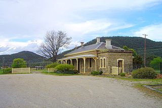
Tarana railway station is a heritage-listed railway station located on the Main Western line in Tarana, City of Lithgow, New South Wales, Australia. It is also known as the Tarana Railway Station and yard group. The property was added to the New South Wales State Heritage Register on 2 April 1999.

The Grenfell railway station is a heritage-listed closed railway station located on the Koorawatha-Grenfell railway line in Grenfell in the Weddin Shire of New South Wales, Australia. The property was added to the New South Wales State Heritage Register on 2 April 1999.

The Queanbeyan railway bridges over Queanbeyan and Molonglo Rivers are two heritage-listed railway bridges that carry the Bombala railway line in the Queanbeyan-Palerang Region local government area of New South Wales, Australia. Both bridges were built between 1926 and 1927. The westernmost bridge crosses the Queanbeyan River from Queanbeyan to Queanbeyan East at 35.3424°S 149.2317°E, while the easternmost bridge crosses the Molonglo River at Burbong at 35.3371°S 149.3191°E. The two railway bridges are owned by Transport Asset Holding Entity, an agency of the Government of New South Wales. Together, the two bridges were added to the New South Wales State Heritage Register on 2 April 1999.
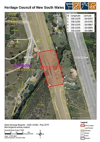
The Marrangaroo railway viaduct is a heritage-listed railway viaduct that carries the Main Western Line across Marrangaroo Creek at Marrangaroo in the City of Lithgow local government area of New South Wales, Australia. The property added to the New South Wales State Heritage Register on 2 April 1999.

The Rydal rail underbridges are a series of heritage-listed railway underbridges and viaducts that carry the Main Western line over Solitary Creek at Rydal, in the City of Lithgow local government area of New South Wales, Australia. The property is owned by Transport Asset Holding Entity, an agency of the Government of New South Wales. It was added to the New South Wales State Heritage Register on 2 April 1999.

