Coxs River track

Last updated

Coxs River track
Australia New South Wales relief location map.png
Red pog.svg
Location of Coxs River track in New South Wales
Location Coxs River Arms, Lake Burragorang/Warragamba Dam, City of Blue Mountains, New South Wales, Australia
Coordinates 33°51′37″S150°20′58″E / 33.8603°S 150.3495°E / -33.8603; 150.3495 Coordinates: 33°51′37″S150°20′58″E / 33.8603°S 150.3495°E / -33.8603; 150.3495
Owner Sydney Catchment Authority
Official nameTrack
TypeState heritage (built)
Designated18 November 1999
Reference no.1372
TypeTrail/Track
CategoryTransport - Land

The Coxs River track is a heritage-listed former walking track and road and now walking track at Cox's River Arms, Lake Burragorang/Warragamba Dam, City of Blue Mountains, New South Wales, Australia. The track is also known as the Warragamba Dam - Burragorang Valley - Wentworth Falls Track. The property is owned by the Sydney Catchment Authority, an agency of the Government of New South Wales. It was added to the New South Wales State Heritage Register on 18 November 1999. [1]

Contents

History

One of the first places in the Gundungurra traditional homelands that most appealed to the Anglo-Celt settlers were the river flats of the Burragorang Valley (now flooded under Warragamba Dam). Even before the valley was officially surveyed in 1827–8, many early settlers were already squatting on blocks that they planned to officially occupy following the issue of freehold title grants. From the Burragorang Valley and using Aboriginal pathways, other valleys to the west were occupied and developed by the settlers with construction of outstations and stock routes. These cattle entrepreneurs were then followed by cedar-wood extractors and miners. [1]

The Gundungurra traditional owners resisted the taking of their lands, and, relying on various laws of the colony at the time, continually applied for official ownership. Although their individual claims failed, in some kind of recognition of the significance of the designated tracts of land claimed, six Aboriginal Reserves (under the control of the NSW Aborigines Protection Board) were formally declared in the Burragorang Valley. Even after these reserves were revoked, many of the traditional owners remained, quietly refusing to leave their traditional homelands. [1]

Finally pushed into the "Gully", a fringe development in West Katoomba from about 1894, the Gully community stayed together for more than 60 years until dispossessed of the Gully by the then Blue Mountains Shire Council so a group of local businessmen could develop a speedway that became known as the Catalina Race Track. The Gully people kept talking about areas of land they had walked in as children - the nearby Megalong and Kanimbla Valleys and the Burragorang Valley. They knew of the profound significance of these valleys for their parents and grandparents. [2] [1]

Description

The track was built by the Pearce family around 1870 using packed stone and earth. The track is substantially intact. [1]

The track leads to the Wentworth Falls in the Burragorang Valley. [1]

The heritage listing by the New South Wales Office of Environment and Heritage [1] gives the primary address of the track as "Coxs River Arms, Lake Burragorang, Warragamba Dam, NSW." However, when the co-ordinates provided in the article (Lat: -33.8548514027 Long: 150.3385892100) are searched in Google maps, the point is shown as being on the western side of the Kedumba River, near its junction with Coxs River Arm. The river must be crossed to walk to Wentworth Falls. A logical starting point for the track is at the point where Kedumba Valley Road nearly touches Coxs River Arm, at co-ordinates -33.860317, 150.349545 (provided by Google maps). From this point, Kedumba Valley Road proceeds to its junction with Tableland Road, which then proceeds to the Great Western Highway at Wentworth Falls, a distance of about 25 km. The heritage listing states that the track is a "former walking track and road."

The Kedumba River crossing campground is situated about 16 km from Wentworth Falls and 9 km from Coxs River Arm. Public access is prohibited along part of the track, below the campground. [3]

Heritage listing

The track is a historically significant archaeological relic built by Europeans as a route of transportation on settlement of the Burragorang Valley. It is representative of a very early form of road construction, evidenced by its design and siting. It has immense historical value as it facilitated the European exploration and expansion of the valley. There are anecdotal linkages to the Pearce family, who were active settlers within the upper reaches of the Blue Mountains. It is a significant component of the cultural landscape and is understood to be exceedingly rare because of the high level of intactness noted in the remaining fabric. [1]

Track was listed on the New South Wales State Heritage Register on 18 November 1999 having satisfied the following criteria. [1]

The place possesses uncommon, rare or endangered aspects of the cultural or natural history of New South Wales.

This item is assessed as historically rare statewide. [1]

The place is important in demonstrating the principal characteristics of a class of cultural or natural places/environments in New South Wales.

This item is assessed as aesthetically representative regionally. [1]

See also

Related Research Articles

<span class="mw-page-title-main">Blue Mountains (New South Wales)</span> Region in New South Wales, Australia

The Blue Mountains are a mountainous region and a mountain range located in New South Wales, Australia. The region is considered to be part of the western outskirts of the Greater Sydney Region, The region borders on Sydney's main metropolitan area, its foothills starting about 50 kilometres (31 mi) west of centre of the state capital, close to Penrith on the outskirts of Greater Sydney region. The public's understanding of the extent of the Blue Mountains is varied, as it forms only part of an extensive mountainous area associated with the Great Dividing Range. As defined in 1970, the Blue Mountains region is bounded by the Nepean and Hawkesbury rivers in the east, the Coxs River and Lake Burragorang to the west and south, and the Wolgan and Colo rivers to the north. Geologically, it is situated in the central parts of the Sydney Basin.

<span class="mw-page-title-main">Katoomba, New South Wales</span> Chief town of the City of Blue Mountains in New South Wales, Australia

Katoomba is the chief town of the City of Blue Mountains in New South Wales, Australia, and the administrative headquarters of Blue Mountains City Council. The council's understanding is that Katoomba is located on the lands of the Dharug and Gundungurra Aboriginal peoples. Katoomba is situated on the Great Western Highway, Katoomba is also known as a suburb of Greater Sydney but is known as a town which is home to the three sisters, 102 km (63 mi) west of Sydney Central Business District and 39 km (24 mi) south-east of Lithgow. Katoomba railway station is on the Main Western line.

<span class="mw-page-title-main">Blue Mountains National Park</span> Protected area in New South Wales, Australia

The Blue Mountains National Park is a protected national park that is located in the Blue Mountains region of New South Wales, in eastern Australia. The 267,954-hectare (662,130-acre) national park is situated approximately 80 kilometres (50 mi) west of Sydney, and the park boundary is quite irregular as it is broken up by roads, urban areas and inholdings. Despite the name mountains, the area is an uplifted plateau, dissected by a number of larger rivers. The highest point in the park is Mount Werong at 1,215 metres (3,986 ft) above sea level; while the low point is on the Nepean River at 20 metres (66 ft) above sea level as it leaves the park.

<span class="mw-page-title-main">Kanangra-Boyd National Park</span> Protected area in New South Wales, Australia

The Kanangra-Boyd National Park is a protected national park that is located in the Central Tablelands region, west of the Southern Highlands and Macarthur regions, in New South Wales, in eastern Australia. The 68,660-hectare (169,700-acre) national park is situated approximately 180 kilometres (110 mi) south-west of Sydney and is contiguous with the Blue Mountains National Park and the Nattai National Park. The park was established in 1969.

<span class="mw-page-title-main">Nattai National Park</span> Protected area in New South Wales, Australia

The Nattai National Park is a protected national park that is located in the Macarthur and Southern Highlands regions of New South Wales, in eastern Australia. 48,984-hectare (121,040-acre) It is situated approximately 150 kilometres (93 mi) southwest of the Sydney central business district and primarily encompasses the valley of the Nattai River, which is surrounded by spectacular sandstone cliffs. Part of the Southern Highlands Shale Forest and Woodland, the park is covered in dry sclerophyll forest – mostly eucalypt and has fairly frequent forest fires. It is largely an untouched wilderness area and receives very few visitors, as it has virtually no facilities and is fairly remote, despite its proximity to Sydney.

<span class="mw-page-title-main">Warragamba Dam</span> Dam in Warragamba, New South Wales

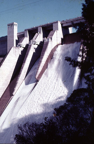
Warragamba Dam is a heritage-listed dam in the outer South Western Sydney suburb of Warragamba, Wollondilly Shire in New South Wales, Australia. It is a concrete gravity dam, which creates Lake Burragorang, the primary reservoir for water supply for the city of Sydney. The dam wall is located approximately 65 kilometres (40 mi) W of Sydney central business district, 4½ km SW of the town of Wallacia, and 1 km NW of the village of Warragamba.

<span class="mw-page-title-main">Lake Burragorang</span> Body of water

Lake Burragorang is a man-made reservoir in the lower Blue Mountains of New South Wales, Australia, serving as a major water supply for greater metropolitan Sydney. The dam impounding the lake, the Warragamba Dam, is located approximately 60 kilometres (37 mi) southwest of the Sydney central business district.

<span class="mw-page-title-main">Jamison Valley</span> Valley in New South Wales Australia

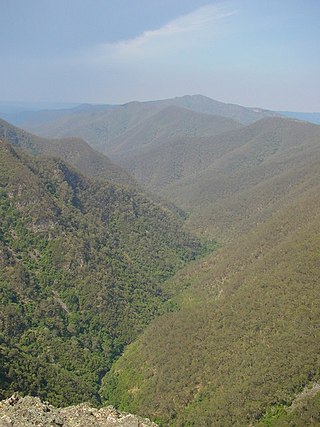
The Jamison Valley forms part of the Coxs River canyon system in the Blue Mountains of New South Wales, Australia. It is situated approximately 100 kilometres west of Sydney, capital of New South Wales, and a few kilometres south of Katoomba, the main town in the Blue Mountains.

Warragamba is a town in New South Wales, Australia, in Wollondilly Shire. Located on the eastern edge of the Blue Mountains, Warragamba is one and a half hour's drive west of Sydney. The name Warragamba comes from the aboriginal words Warra and Gamba meaning 'water running over rocks'.

<span class="mw-page-title-main">Megalong Valley</span>

Megalong Valley is part of the Blue Mountains of New South Wales, Australia. It is located west of Katoomba. On its eastern side, the valley is separated from the Jamison Valley by Narrow Neck Plateau. The Shipley Plateau overlooks part of the valley.

<span class="mw-page-title-main">City of Blue Mountains</span> Local government area in New South Wales, Australia

The City of Blue Mountains is a local government area of New South Wales, Australia, governed by the Blue Mountains City Council. The city is located in the Blue Mountains, it’s located on the Great Dividing Range on the western edge of the Greater Sydney Region in New South Wales, Australia.

<span class="mw-page-title-main">Wentworth Falls, New South Wales</span> Suburb of City of Blue Mountains, New South Wales, Australia

Wentworth Falls is a town in the Blue Mountains region of New South Wales, situated approximately 100 kilometres (62 mi) west of the Sydney central business district, and about 8 kilometres (5.0 mi) east of Katoomba, Australia on the Great Western Highway, with a Wentworth Falls railway station on the Main Western line. The town is at an elevation of 867 metres (2,844 ft) AHD . At the 2016 census, Wentworth Falls had a population of 6,076.

<span class="mw-page-title-main">Coxs River</span> River in New South Wales, Australia

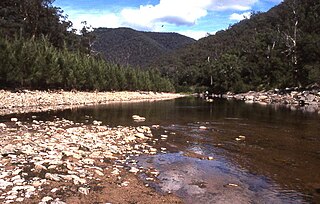
The Coxs River, a perennial river that is part of the Hawkesbury-Nepean catchment, is located in the Central Tablelands, Blue Mountains, and Macarthur regions of New South Wales, Australia.

<span class="mw-page-title-main">Catalina Park</span>

Catalina Park is a disused motor racing venue, located at Katoomba, in the Blue Mountains, New South Wales, Australia, and is recognised as an Aboriginal Place due to the long association of the local Gundungarra and Darug clans to the area.

<span class="mw-page-title-main">Mount Solitary</span> Mountain in New South Wales, Australia

Mount Solitary, a mountain that is part of the Blue Mountains Range, a spur off the Great Dividing Range, is situated within the Blue Mountains National Park, New South Wales, Australia. Mount Solitary is located approximately 100 kilometres (62 mi) west of Sydney, and a few kilometres south of Katoomba, the main town in the Blue Mountains.

<span class="mw-page-title-main">Warragamba River</span> River in New South Wales, Australia

The Warragamba River, a river that is part of the Hawkesbury-Nepean catchment, is located in the Macarthur region of New South Wales, Australia.

<span class="mw-page-title-main">Kings Tableland</span>

The Kings Tableland is a plateau, located in the Blue Mountains in Wollondilly Shire, New South Wales, Australia. The ridge is an eroded remnant of a sandstone layer that is approximately 1,000 metres (3,300 ft) AMSL, situated immediately south of Wentworth Falls. The Tableland is the major southerly spur of the main spine of the Blue Mountains Range and forms the beginning of the Southern Escarpment, an unbroken series of tall sandstone cliffs which fringes the Jamison, Megalong, Kanimbla and Hartley Valleys.

<span class="mw-page-title-main">Kedumba River</span> River in New South Wales, Australia

The Kedumba River, a perennial river that is part of the Hawkesbury-Nepean catchment, is located in the Blue Mountains and Macarthur regions of New South Wales, Australia.

Warragamba Dam - Haviland Park is a heritage-listed former farm, dam, timber getting, Gundungurra traditional lands and squatter's land and now parkland located at Warragamba Dam in the south-western Sydney settlement of Warragamba in the Wollondilly Shire local government area of New South Wales, Australia. The property is owned by Water NSW, an agency of the Government of New South Wales. It was added to the New South Wales State Heritage Register on 18 November 1999.

References

  1. 1 2 3 4 5 6 7 8 9 10 11 "Track". New South Wales State Heritage Register . Department of Planning and Environment. H01372. Retrieved 2 June 2018. CC-BY icon.svg Text is licensed by State of New South Wales (Department of Planning and Environment) under CC-BY 4.0 licence .
  2. Johnson, 2009, 4
  3. "Protected and Special Areas". Water NSW. Archived from the original on 14 June 2019. Retrieved 15 October 2019.

Bibliography

Attribution

CC BY icon-80x15.png This Wikipedia article was originally based on Track , entry number 01372 in the New South Wales State Heritage Register published by the State of New South Wales (Department of Planning and Environment) 2018 under CC-BY 4.0 licence , accessed on 2 June 2018.