Glenbrook, New South Wales

Last updated

Glenbrook
Blue Mountains,  New South Wales
Rlwy stn glenbrook.jpg
Glenbrook railway station
Australia New South Wales location map blank.svg
Red pog.svg
Glenbrook
Glenbrook, New South Wales
Coordinates 33°46′00″S150°37′10″E / 33.76667°S 150.61944°E / -33.76667; 150.61944
Population5,078 (2021 census) [1]
Establishedapprox. 1870 (approx. 153 years old)
Postcode(s) 2773
Elevation163 m (535 ft)
Location
LGA(s) City of Blue Mountains
State electorate(s) Blue Mountains
Federal division(s) Macquarie
Suburbs around Glenbrook:
Blaxland Blaxland
Glenbrook
Lapstone
Overlooking Glenbrook Creek and the Blue Mountains line Glen brook creek3.JPG
Overlooking Glenbrook Creek and the Blue Mountains line

Glenbrook is a township of the Lower Blue Mountains of New South Wales, Australia. It is located 63 kilometres west of the Sydney central business district, in the local government area of the City of Blue Mountains. As of the 2021 Australian census Glenbrook had a population of 5,078 people. [1]

Contents

Glenbrook lies between Lapstone and Blaxland at an elevation of 163 metres (535 feet) and is approximately a 50-minute drive from Sydney. It plays host to trendy cafes and boutiques, while offering various tourist attractions, including weekend markets, recreational opportunities and native flora and fauna.

The town takes its name from Glenbrook Creek, which is on the southern side of the village and must be crossed to enter the Blue Mountains National Park. Glenbrook retains many historical homes and buildings throughout the village, although most of these are occupied and not open to the public.

History

Blaxland, Wentworth and Lawson reached Glenbrook area and Lagoon on their trek across the Blue Mountains on 12 May 1813 and described it as "a large lagoon of good water full of very coarse rushes". [2]

In 1815, William Cox constructed the first road over the Blue Mountains with a gang of convicts and the Glenbrook area became an important stopping point after a storeroom was built near the lagoon. Governor Macquarie also built a military depot near the lagoon to monitor traffic on the newly built road. [2]

After years of use, Cox's road up Lapstone Hill ran into a few problems. It was very steep in sections and in rain became slippery. A new road and stone bridge was built and opened to traffic in 1833 "The Western Road", at what is today Mitchell's Pass, planned and built by Thomas Livingstone Mitchell. The Stone Bridge, Lennox Bridge completed in 1833 and designed by Scottish stonemason David Lennox is the oldest surviving stone bridge on the Australian mainland.

Glenbrook became a town in the 1870s as a result of the arrival of the railway. In 1867 a zigzag railway was built up the Lapstone Hill and on to Weatherboard "Wentworth Falls". A siding was also built at Glenbrook "Wascoe's Siding", named after an Inn from the local area, water from Glenbrook Lagoon was piped to supply the trains after traversing the Lapstone ZigZag. This Wascoe Siding became a passenger station in 1877. In 1878, Sir Alfred Stephen, Chief Justice and Privy Councillor, decided to give the station a proper name and called it Brookdale, but later it was officially changed to Glenbrook in 1879, named after the nearby creek and Gorge. [2] Glenbrook, which Sir John Jamison thought came from Regents Glen. A village sprung up near the station and was officially proclaimed Glenbrook, six years later.

The Lapstone ZigZag opened in 1867, a part of the ascent of Lapstone Hill on a gradient of 1 in 30–33, which was built up the side of the range with comparatively light earthwork, although it includes the substantial seven-span sandstone Knapsack Viaduct. This was later widened to carry the old Great Western Highway, and it is now part of a walking trail on the old railway/highway alignment, including a memorial to the engineer in charge of the construction of the Blue Mountains line and many other early railways, John Whitton.

In 1892 the first deviation of the railway up the Lapstone Hill, bypassed the Lapstone Zig Zag altogether. A tunnel was built through the hill to the Old Glenbrook station (subsequently dismantled). The 1892 Glenbrook Tunnel ran into trouble with water seeping from the nearby creek and the steep gradient making the climb hard for most trains, often getting stuck in the tunnel. [3]

In 1913 the second deviation of the railway line up Lapstone Hill was completed with a new double-tracked 1913 tunnel at the Bluff Point. The old 1892 Glenbrook Tunnel was subsequently closed. As a result of the new line, the Old Glenbrook station was relocated from next to the Great Western Highway to its current location next to the village of Glenbroook at the end of Ross Street, and was officially opened 11 May 1913. [4]

The abandoned 1892 Glenbrook Tunnel has been used to store mustard gas during World War II, and grow mushrooms in recent times. The eastern entrance can be still seen from a walking track at Lapstone. [5] [6] [7]

On 28 January 1941, an Avro Anson of No. 1 Air Navigation School, Parkes crashed near Glenbrook during a medical evacuation flight from Parkes to the Sydney Airport. [8] All five crew members were killed. [8]

In 1999, the town was associated with the Glenbrook train disaster.

Since 2005, the suburb has been the home of The Australian Gnome Convention organised by the Rotary Club of Lower Blue Mountains and held on Australia Day each year. Owners of garden gnomes display their garden decorations and compete for various awards to raise funds for charities. [9]

Bushwalking

Glenbrook hosts many walking tracks that can be trekked, including the popular walk to Red Hands Cave, from Glenbrook Causeway, which is a 5.8 km walk from Glenbrook's town centre. [10] [11]

Glenbrook also has walks that are scenic, but not well known. This includes the untracked walk to Warrimoo via Glenbrook Gorge, and the walk to Pippas Pass. [12] [13]

Additionally, Glenbrook hosts many natural pools, that can be accessed by walking tracks from the town centre, by a few kilometres. [11]

Pools

Glenbrook's pools are popular for swimming in, and their tranquillity. [14]

These pools are easily accessed by several walking tracks from the town centre.

Glenbrook's Pools include:

Heritage listings

New South Wales State Heritage Register

Glenbrook has a number of heritage-listed sites, including the following items listed on the New South Wales State Heritage Register:

City of Blue Mountains local government heritage register

Ilford House, Wascoe Street (1)Ilford House Wascoe Street Glenbrook-1.jpg
Ilford House, Wascoe Street
Bonnie Doone, Moore Street (1)Bonnie Doone Moore Street Glenbrook.jpg
Bonnie Doone, Moore Street

Glenbrook has a number of heritage-listed sites, including the following items listed on the City of Blue Mountains local government heritage register, as recorded in the New South Wales Heritage Database: [19]

  • Blue Mountains National Park: Red Hand Cave
  • 67 Brook Road: The Bluff
  • Burfitt Parade: Glenbrook railway station
  • 2 Cross Street: House
  • 15 Euroka Road: Thurso
  • 26 Explorers Road: House
  • 175 Explorers Road: The Spurline
  • Great Western Highway: Glenbrook Deviation (1913)
  • 2 Great Western Highway: Gatekeeper's Cottage No 1
  • 2 Great Western Highway: Whitton Memorial
  • 15 Great Western Highway: Glenbrook Deviation (1892)
  • 15-17 Great Western Highway: Lapstone Zig Zag
  • 29 Great Western Highway: Briarcliffe (now RAAF Base Glenbrook)
  • 29 Great Western Highway: Former Lapstone Hotel (now RAAF Base Glenbrook)
  • 41 Great Western Highway: Blaxland, Wentworth and Lawson Memorial
  • 41 Great Western Highway: Glenbrook Native Plant Reserve
  • 41 Great Western Highway: Original Glenbrook Railway Sign and Monument
  • 12 Hare Street: Glenbrook School of Music
  • Off Knapsack Street: Lucasville Station
  • 15-19 Lagoon Drive: Glenbrook Lagoon
  • 33 Lucasville Road: Phoenix Palm Group
  • 37 Lucasville Road: Kalamunda
  • 2 Mann Street: House
  • 9 Mann Street: House
  • 33 Moore Street: Bonnie Doone
  • 6 Nepean Gardens Place: Ulinbawn
  • 4 Park Street: Serendip
  • 6 Park Street: Glenbrook Cottage
  • 10 Park Street: Glenbrook Primary School
  • 10 Park Street: The Warruwii Centre – Building B00A
  • 20-30 Park Street: Glenbrook Park
  • 23-29 Park Street: Green Real Estate
  • 41 Park Street: Briar Hill
  • 51 Park Street: "Girrahween"
  • 2 Ross Street: Horse Trough
  • 20 Ross Street: Glenbrook Garden Centre
  • 6 Raymond Street: House
  • 8 Raymond Street: House
  • 6 Wascoe Street: House
  • 8 Wascoe Street: Ilford, house and garden
  • 9 Waters Road: Arcadia

Population

In the 2021 Census, there were 5,078 people in Glenbrook. 83.9% of people were born in Australia. The next most common country of birth was England at 5.2%. 90.9% of people spoke only English at home. The most common responses for religion were No Religion 41.6%, Catholic 22% and Anglican 15.9%. [1]

Transport

Glenbrook railway station is on the Blue Mountains Line of the NSW TrainLink intercity network. Also, the Great Western Highway passes through the town.

Landmarks

Recreation

Founded in 1975, Lapstone Glenbrook Netball Club [20] was formed from a merger between what was St Peter's Netball Club and school-based teams at Lapstone Public School [21] and Glenbrook Public School. [22] St Peter's Netball Club was a founding club of the Blue Mountains Netball Association [23] and was run from the church organisation previously based in the St Peter's Anglican Church building which is now used as a cafe in Glenbrook). Netball is currently the largest participation sport in the Blue Mountains and all matches are played at the Lapstone complex.

Other sporting clubs in the area include:

Other non-sporting club based recreational activities include:

See also

Related Research Articles

<span class="mw-page-title-main">Blue Mountains (New South Wales)</span> Mountain range in Australia

The Blue Mountains are a mountainous region and a mountain range located in New South Wales, Australia. The region is considered to be part of the western outskirts of the Greater Sydney area. The region borders on Sydney's main metropolitan area, its foothills starting about 50 kilometres (31 mi) west of centre of the state capital, close to Penrith. The public's understanding of the extent of the Blue Mountains is varied, as it forms only part of an extensive mountainous area associated with the Great Dividing Range. As defined in 1970, the Blue Mountains region is bounded by the Nepean and Hawkesbury rivers in the east, the Coxs River and Lake Burragorang to the west and south, and the Wolgan and Colo rivers to the north. Geologically, it is situated in the central parts of the Sydney Basin.

<span class="mw-page-title-main">Great Western Highway</span> Highway in New South Wales

Great Western Highway is a 202-kilometre-long (126 mi) state highway in New South Wales, Australia. From east to west, the highway links Sydney with Bathurst, on the state's Central Tablelands.

<span class="mw-page-title-main">Warrimoo, New South Wales</span> Town in New South Wales, Australia

Warrimoo is a medium-sized village in the lower Blue Mountains of New South Wales, Australia, 273 metres above sea level. The state government's electorate is Blue Mountains and the state member is Labor's Trisha Lee Doyle.

<span class="mw-page-title-main">Blaxland, New South Wales</span> Town in New South Wales, Australia

Blaxland is a town in the Blue Mountains of New South Wales, Australia. Blaxland is located 65 kilometres west of Sydney in the local government area of the City of Blue Mountains. It is at an altitude of 234 metres and borders the townships of Glenbrook, Mount Riverview and Warrimoo.

<span class="mw-page-title-main">City of Blue Mountains</span> Local government area in New South Wales, Australia

The City of Blue Mountains is a local government area of New South Wales, Australia, governed by the Blue Mountains City Council. The city is located in the Blue Mountains, on the Great Dividing Range at the far western fringe of the Greater Sydney area. Major settlements include, Katoomba, Lawson, Springwood and Blaxland.

<span class="mw-page-title-main">Mount Victoria, New South Wales</span> Town in New South Wales, Australia

Mount Victoria is a village in the Blue Mountains of New South Wales, Australia. Mount Victoria is geographically the western most village and suburb of Greater Sydney on the great western highway in the City of Blue Mountains, located about 120 kilometres (75 mi) west-northwest by road from the Sydney central business district and at an altitude of about 1,052 metres (3,451 ft) AHD . The settlement had a population of 823 people at the 2011 Census.

<span class="mw-page-title-main">Lapstone, New South Wales</span> Suburb of Blue Mountains, New South Wales, Australia

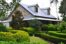
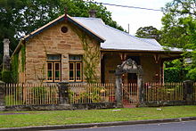
Lapstone is a township on the eastern escarpment of the Blue Mountains in New South Wales, Australia. Elevation 160 m (525 ft). Lapstone is located 62 kilometres west of the Sydney CBD in the local government area of the City of Blue Mountains and is part of the federal electorate of Macquarie. Lapstone consists mostly of stand-alone housing and has a few public facilities. At the 2016 census, Lapstone had a population of 961 people. Lapstone was originally bought and developed by Mr Arthur J Hand, an Alderman of the Blue Mountains City Council.

<span class="mw-page-title-main">Lapstone Zig Zag</span> Bridge in New South Wales, Australia

The Lapstone Zig Zag was a zig zag railway built between Emu Plains and Blaxland stations on the Main Western Line of New South Wales in Australia. Constructed between 1863 and 1865 to overcome an otherwise insurmountable climb up the eastern side of the Blue Mountains, the zig zag and associated Knapsack Viaduct, a sandstone arch viaduct, were designed by John Whitton, Engineer-in-Charge of New South Wales Government Railways, and were built by William Watkins. The zig zag was listed on the Blue Mountains local government heritage register on 27 December 1991; while the adjacent Knapsack Viaduct was listed on the New South Wales Heritage Database on 2 April 1999. The Lapstone Zig Zag was the world-first Zig Zag constructed on any main-line railway.

RAAF Base Glenbrook is a Royal Australian Air Force (RAAF) base located in Glenbrook, in the Lower Blue Mountains, approximately 60 kilometres (37 mi) west of the Sydney central business district in New South Wales, Australia.

<span class="mw-page-title-main">John Whitton</span> Anglo–Australian railway engineer

John Whitton, an Anglo–Australian railway engineer, was the Engineer-in-Charge for the New South Wales Government Railways, serving between 1856 and 1890, considered the Father of New South Wales Railways. Under his supervision, it is estimated that 2,171 miles (3,494 km) of railway around New South Wales and Victoria were completed. Whitton was responsible for the construction of parts of the Main Western railway line, in particular the section over the Blue Mountains and the Lithgow Zig Zag, and much of the Main Southern railway line.

<span class="mw-page-title-main">M4 Motorway (Sydney)</span> Motorway in Sydney

The M4 Motorway is a 55-kilometre (34 mi) series of partially-tolled dual carriageway motorways in Sydney, New South Wales designated as route M4. The M4 designation is part of the wider A4 and M4 route designation, the M4 runs parallel and/or below ground to Great Western Highway, Parramatta Road and City West Link, which are part of route A44.

<span class="mw-page-title-main">Woodford, New South Wales</span> Town in New South Wales, Australia

Woodford is a village in the Blue Mountains in New South Wales, Australia, about 90 kilometres west of the Sydney CBD. Its elevation is 609 metres (1,998 ft) above sea level. It is situated on the Great Western Highway and has a railway station on the Main Western railway line served by NSW TrainLink's Blue Mountains services. At the 2016 census, Woodford had a population of 1,934.

<span class="mw-page-title-main">Lithgow Zig Zag</span> Railway line in New South Wales, Australia

The Lithgow Zig Zag is a heritage-listed former zig zag railway line built near Lithgow on the Great Western Line of New South Wales in Australia. The zig zag line operated between 1869 and 1910, to overcome an otherwise insurmountable climb and descent on the western side of the Blue Mountains. It was designed by John Whitton and built from 1863 to 1869 by Patrick Higgins as contractor. It is also known as the Great Zig Zag Railway and Reserves and Zig Zag Railway. The property is owned by Department of Planning and Infrastructure. It was added to the New South Wales State Heritage Register on 2 April 1999.

Lapstone Oval is a sports precinct in Lapstone, New South Wales. It supports sport all year round. The name Lapstone Oval covers all of the 3 different types of sporting facilities and not just the rugby field as is thought by some people, however the mightiest club in Subbies Rugby calls Lapstone Oval home. It is known to many opposition teams as the Graveyard; as many teams come to the foot of the mountains to be buried by the mighty Blue Men. Curator Matthew Lehn welcomes opposing teams with "welcome to the Graveyard"

The Glenbrook deviation was a section of track on the Main Western line from the first Knapsack Viaduct to old Glenbrook station in the Blue Mountains of New South Wales, Australia. The approximately five-mile-long (eight-kilometre) deviation was constructed from 1891 to 1892 and replaced the Lapstone Zig Zag. The deviation was closed in 1913 when it was replaced by the second Glenbrook deviation and the second Glenbrook Tunnel, that continues to carry the Main Western line today.
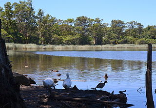
<span class="mw-page-title-main">Lennox Bridge, Glenbrook</span> Bridge in New South Wales, Australia

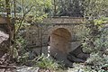
The Lennox Bridge, Glenbrook is a heritage-listed road bridge that carries the Mitchell's Pass across Brookside Creek, located at Glenbrook, in the City of Blue Mountains local government area of New South Wales, Australia. The bridge was designed by David Lennox and built from 1832 to 1833 by James Randall and other convicts. It is also known as Lennox Bridge or The Horseshoe Bridge. The property is owned by Blue Mountains City Council. It was added to the New South Wales State Heritage Register on 2 April 1999. The stone arch bridge is a single arch of 6 metres (20 ft) span and is 9 metres (30 ft) above water level, with a road width of 9 metres (30 ft).

<span class="mw-page-title-main">Glenbrook Tunnel (1892)</span>

The Glenbrook Tunnel is a heritage-listed single-track former railway tunnel and mustard gas storage facility and previously a mushroom farm located on the former Main Western Line at the Great Western Highway, Glenbrook, in the City of Blue Mountains local government area of New South Wales, Australia. The Department of Railways designed the tunnel and built it from 1891 to 1892. It is also known as Lapstone Hill tunnel and Former Glenbrook Railway and World War II Mustard Gas Storage Tunnel. The property is owned by Blue Mountains City Council and Land and Property Management Authority, an agency of the Government of New South Wales. It was added to the New South Wales State Heritage Register on 5 August 2011. The railway tunnel was originally part of the Glenbrook 1892 single-track deviation, which bypassed the Lapstone Zig Zag across the Blue Mountains. It is 634 metres; 693 yards long and is constructed in an 'S' shape with a gradient of 1:33.

The Glenbrook Tunnel is a double-track railway tunnel located on the Main Western Line, near Glenbrook, in the City of Blue Mountains local government area of New South Wales, Australia. The property is owned by the Transport Asset Holding Entity. The railway tunnel is part of the Glenbrook 1913 double-track deviation, which replaced the Glenbrook 1892 single-track deviation across the Blue Mountains. The tunnel is 283 metres (928 ft) long and was officially opened on 11 May 1913.

The Glenbrook deviation is a section of track on the Main Western line from Emu Plains to Blaxland stations in the Blue Mountains of New South Wales, Australia. The approximately seven-mile-long (eleven-kilometre) double-track deviation was constructed from 1911 to 1913 and replaced the single-track first Glenbrook deviation and the first Glenbrook Tunnel.

References

  1. 1 2 3 Australian Bureau of Statistics (28 June 2022). "Glenbrook (State Suburb)". 2021 Census QuickStats. Retrieved 30 July 2023. OOjs UI icon edit-ltr-progressive.svg CC-BY icon.svg Material was copied from this source, which is available under a Creative Commons Attribution 4.0 International License.
  2. 1 2 3 "Glenbrook, NSW". Aussie Towns. Retrieved 1 March 2019.
  3. 1 2 "Glenbrook Railway and World War Two Mustard Gas Storage Tunnel". New South Wales State Heritage Register . Department of Planning & Environment. H01861. Retrieved 18 May 2018. CC BY icon.svg Text is licensed by State of New South Wales (Department of Planning and Environment) under CC-BY 4.0 licence .
  4. "Glenbrook Railway Station Group". New South Wales State Heritage Register . Department of Planning & Environment . Retrieved 2 March 2019. CC BY icon.svg Text is licensed by State of New South Wales (Department of Planning and Environment) under CC-BY 4.0 licence .
  5. Walker, Frank (20 January 2008). "Deadly chemicals hidden in war cache". The Sydney Morning Herald . Retrieved 27 September 2018.
  6. Plunkett, Geoff. "Depots: Glenbrook funnel". Chemical Warfare in Australia. Department of Defence. Retrieved 27 September 2018.
  7. Plunkett, Geoff. "Home page". Chemical Warfare in Australia. Department of Defence. Retrieved 27 September 2018.
  8. 1 2 Dunn, Peter. "CRASH OF AN AVRO ANSON AT GLENBROOK, NSW ON 28 JANUARY 1941". ozatwar.com. Retrieved 15 January 2013.
  9. "Australian Gnome Convention".
  10. Chapman, John. Day Walks Sydney. p. 60.
  11. 1 2 3 4 Chapman, John. Day Walks Sydney. p. 62.
  12. Chapman, John. Day Walks Sydney. p. 69.
  13. Chapman, John. Day Walks Sydney. pp. 65–70.
  14. Chapman, John. Day Walks Sydney. p. 64.
  15. "Blue Mountains Walking tracks". New South Wales State Heritage Register . Department of Planning & Environment. H00980. Retrieved 18 May 2018. CC BY icon.svg Text is licensed by State of New South Wales (Department of Planning and Environment) under CC-BY 4.0 licence .
  16. "Knapsack Viaduct, Lapstone". New South Wales Heritage Database. Office of Environment & Heritage . Retrieved 2 June 2018.
  17. "Glenbrook Railway Residence". New South Wales State Heritage Register . Department of Planning & Environment. H00713. Retrieved 18 May 2018. CC BY icon.svg Text is licensed by State of New South Wales (Department of Planning and Environment) under CC-BY 4.0 licence .
  18. "Lennox Bridge". New South Wales State Heritage Register . Department of Planning & Environment. H00024. Retrieved 18 May 2018. CC BY icon.svg Text is licensed by State of New South Wales (Department of Planning and Environment) under CC-BY 4.0 licence .
  19. "Search: Glenbrook". New South Wales Heritage Database . Office of Environment and Heritage . Retrieved 17 May 2020.
  20. "Lapstone Glenbrook Netball Club".
  21. "Lapstone Public School". www.lapstonepublic.com.au. Archived from the original on 21 May 2018. Retrieved 20 May 2018.
  22. "Glenbrook Public School".
  23. "Blue Mountains Netball Association".
  24. https://glenbrooklac.org/
  25. Glenbrook Cinema – Official Website