Hokesville, New South Wales

Last updated
The "main street" of Hokesville. Hoaxville main street, 1943.jpg
The "main street" of Hokesville.

Hokesville (also known as Hoaxville) was a fake town in the Blue Mountains of New South Wales, Australia built during World War II as camouflage for a RAAF weapons storage site. [1] [2] It had no actual residents as such but was regularly attended by a "floating population" of Australian military servicemen during the war. [3] The official name for the Hokesville base in reality was No. 1 Central Reserve and Army Ordinance.

Hokesville was constructed in April 1942 on the western slopes of the Blue Mountains, at a site near Marrangaroo. It was the location of a pre-existing large disused railway tunnel which the RAAF determined would be ideal for storing its stockpile of chemical weapons, including phosgene and mustard gas. [4] The tunnel was renovated with concrete floors, electricity and telephones. [5] Real farms and homesteads lay adjacent to the site, along with an old stone church. An average of 6,000 tonnes of bombs passed in and out of the base each month, with 12,000 at its peak in May 1945. [6]

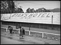
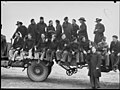
Fears of reconnaissance missions or even air strikes from Japanese planes led to much effort being taken to disguise Hokesville as a functioning town. Real cattle and horses were allowed to graze in the area, and dogs were trained to guard the entrance of the tunnel. [7] A fake horse was also constructed out of papier mache. Numerous fake residences featured porches set up with deck chairs. Empty buildings purporting to be that of various local business were constructed, many with elaborate entrance signs painted for them. These included Higgins & Sons Groceries, Alf Jones' Butcher (with "Alf" being a play on "AIF", the abbreviation for the Australian Imperial Force), Ryan's Hotel, the Beacon Garage complete with gas pumps and even a Hokesville branch of the YMCA. [8]

Once the war ended, the reality of Hokesville was revealed to the Australian public and photographers were invited to document the site. [9] The Hobart Mercury reported that the "lethal liquid and gases probably will be taken out to sea, where the ocean is particularly deep, and dumped." [10] In 2005, it was revealed the chemicals had in fact been buried and left at the site. [11] [12] A remediation project ran from 2008 to 2010, revealing thousands of bomb cases, projectiles, fuses and other military ordinance in the soil. [13] [14]

In 2019, an art installation inspired by Hokesville was displayed as part of the Resilience in Times of Adversity: Contemporary Responses to WW2 in the Blue Mountains 1939-1950 exhibition at the Blue Mountains Cultural Centre in Katoomba. [15] [16]

Related Research Articles

<span class="mw-page-title-main">Lithgow, New South Wales</span> Town in New South Wales, Australia

Lithgow is a town in the Central Tablelands of New South Wales, Australia and is the administrative centre of the City of Lithgow local government area. It is located in a mountain valley named Lithgow's Valley by John Oxley in honour of William Lithgow, the first Auditor-General of New South Wales.

<span class="mw-page-title-main">Glenbrook, New South Wales</span> Town in New South Wales, Australia

Glenbrook is a township of the Lower Blue Mountains of New South Wales, Australia. It is located 63 kilometres west of the Sydney central business district, in the local government area of the City of Blue Mountains. As of the 2021 Australian census Glenbrook had a population of 5,078 people.

<span class="mw-page-title-main">Zig Zag Railway</span> Railway line in New South Wales, Australia

The Zig Zag Railway is an Australian heritage railway, situated near Lithgow, New South Wales. It was opened by the not-for-profit Zig Zag Railway Co-op as an unpaid volunteer-staffed heritage railway in October 1975, using the alignment of the Lithgow Zig Zag line that formed part of the Main Western line between 1869 and 1910. The line climbs the western flank of the Blue Mountains, using railway zig zags to gain height.

<span class="mw-page-title-main">Lapstone, New South Wales</span> Town in New South Wales, Australia

Lapstone is a township on the eastern escarpment of the Blue Mountains in New South Wales, Australia. Elevation 160 m (525 ft). Lapstone is located 62 kilometres west of the Sydney CBD in the local government area of the City of Blue Mountains and is part of the federal electorate of Macquarie. Lapstone consists mostly of stand-alone housing and has a few public facilities. At the 2016 census, Lapstone had a population of 961 people. Lapstone was originally bought and developed by Mr Arthur J Hand, an Alderman of the Blue Mountains City Council.

<span class="mw-page-title-main">Blue Mountains Line</span> Rail service in New South Wales, Australia

The Blue Mountains Line (BMT) is an inter urban commuter rail service operated by NSW TrainLink serving the Blue Mountains region of New South Wales, Australia. The line travels west from Sydney to the major town of Katoomba and on to Mount Victoria, Lithgow and Bathurst. Mount Victoria is the terminus for most electric services, but some services terminate at Lithgow instead. Two express services per day in each direction, known as the Bathurst Bullet, extend to the regional city of Bathurst, which is supplemented by road coaches connecting Bathurst to Lithgow. Due to electrification limits at Lithgow, the Bathurst Bullet is run using the Endeavour railcars, which operate on diesel. The Blue Mountains Line operates over a mostly duplicated section of the Main Western line. As such, the tracks are also traversed by the Central West XPT, Outback Xplorer and Indian Pacific passenger services and by freight trains.

<span class="mw-page-title-main">Glen Davis, New South Wales</span> Town in New South Wales, Australia

Glen Davis is a village in the Central Tablelands of New South Wales, Australia. The village is located in the local government area of the City of Lithgow. It is located 250 km north-west of Sydney and approximately 80 kilometres north of Lithgow. The name is also applied to the surrounding area, for postal and statistical purposes. In the 2006 census, Glen Davis had a population of 354 but this fell to 115 in the 2016 census.

RAAF Base Glenbrook is a Royal Australian Air Force (RAAF) base located in Glenbrook, in the Lower Blue Mountains, approximately 60 kilometres (37 mi) west of the Sydney central business district in New South Wales, Australia.

<span class="mw-page-title-main">No. 29 Squadron RAAF</span> Royal Australian Air Force squadron

No. 29 Squadron is a Royal Australian Air Force (RAAF) reserve squadron located in Hobart, Tasmania. The squadron was formed in September 2001 and has the role of training Tasmanian RAAF reservists for air base protection tasks.

Marrangaroo is a village in the Central West of New South Wales, Australia in the City of Lithgow. The name is also applied to the surrounding area, for postal and statistical purposes.

<span class="mw-page-title-main">City of Lithgow</span> Local government area in New South Wales, Australia

The City of Lithgow is a local government area in the Central West region of New South Wales, Australia. The area is located adjacent to the Great Western Highway and the Main Western railway line.

<span class="mw-page-title-main">Lithgow Zig Zag</span> Railway line in New South Wales, Australia

The Lithgow Zig Zag is a heritage-listed former zig zag railway line built near Lithgow on the Great Western Line of New South Wales in Australia. The zig zag line operated between 1869 and 1910, to overcome an otherwise insurmountable climb and descent on the western side of the Blue Mountains. It was designed by John Whitton and built from 1863 to 1869 by Patrick Higgins as contractor. It is also known as the Great Zig Zag Railway and Reserves and Zig Zag Railway. The property is owned by Department of Planning and Infrastructure. It was added to the New South Wales State Heritage Register on 2 April 1999.

<span class="mw-page-title-main">Little Hartley, New South Wales</span> Town in New South Wales, Australia

Little Hartley is a village in the Central West region of New South Wales, Australia. It is located approximately 150 kilometres west-northwest of Sydney and 20 kilometres south-east of Lithgow, on the Great Western Highway. It is in the local government area of the City of Lithgow.

<span class="mw-page-title-main">Wallerawang</span> Town in New South Wales, Australia

Wallerawang is a small township in the Central Tablelands of New South Wales, Australia. It is located approximately 14 kilometres (8.7 mi) northwest of Lithgow adjacent to the Great Western Highway. It is also located on the Main Western railway line at the junction of the Gwabegar line. The name is also applied to the surrounding area for postal and statistical purposes.

<span class="mw-page-title-main">Alan Charlesworth</span> Royal Australian Air Force senior commander

Air Vice Marshal Alan Moorehouse Charlesworth, CBE, AFC was a senior commander in the Royal Australian Air Force (RAAF). Born in Tasmania, he graduated from the Royal Military College, Duntroon, and served with the 2nd Light Horse Regiment in Queensland before transferring to the Air Force in 1925. Most of his pre-war flying career was spent with No. 1 Squadron at RAAF Station Laverton, Victoria. In 1932 he undertook a series of survey flights around Australia, earning the Air Force Cross. Charlesworth's early wartime commands included No. 2 Squadron at Laverton, and RAAF Station Pearce in Western Australia. Appointed Air Officer Commanding (AOC) Eastern Area in December 1943, he was promoted temporary air commodore the following year and took over as AOC North-Western Area in Darwin, Northern Territory.

<span class="mw-page-title-main">No. 3 Elementary Flying Training School RAAF</span> Military unit

No. 3 Elementary Flying Training School was a Royal Australian Air Force (RAAF) pilot training unit that operated during World War II. It was one of twelve elementary flying training schools employed by the RAAF to provide introductory flight instruction to new pilots as part of Australia's contribution to the Empire Air Training Scheme. No. 3 EFTS was established in January 1940 at Essendon, Victoria, and initially included a significant proportion of civilian staff and private aircraft; by mid-year these had been largely integrated into the military. The school was disbanded in May 1942, its aircraft and instructional staff having been transferred to No. 11 Elementary Flying School at Benalla.

<span class="mw-page-title-main">The Fish (train)</span>

The Fish is the legacy name for the passenger train that operates over the Blue Mountains between Lithgow and Sydney, Australia.

<span class="mw-page-title-main">Glenbrook Tunnel (1892)</span>

The Glenbrook Tunnel is a heritage-listed single-track former railway tunnel and mustard gas storage facility and previously a mushroom farm located on the former Main Western Line at the Great Western Highway, Glenbrook, in the City of Blue Mountains local government area of New South Wales, Australia. The Department of Railways designed the tunnel and built it from 1891 to 1892. It is also known as Lapstone Hill tunnel and Former Glenbrook Railway and World War II Mustard Gas Storage Tunnel. The property is owned by Blue Mountains City Council and Land and Property Management Authority, an agency of the Government of New South Wales. It was added to the New South Wales State Heritage Register on 5 August 2011. The railway tunnel was originally part of the Glenbrook 1892 single-track deviation, which bypassed the Lapstone Zig Zag across the Blue Mountains. It is 634 metres; 693 yards long and is constructed in an 'S' shape with a gradient of 1:33.

<span class="mw-page-title-main">Marrangaroo railway viaduct</span> Heritage listed railway viaduct in New South Wales, Australia

The Marrangaroo railway viaduct is a heritage-listed railway viaduct that carries the Main Western Line across Marrangaroo Creek at Marrangaroo in the City of Lithgow local government area of New South Wales, Australia. The property added to the New South Wales State Heritage Register on 2 April 1999.

Torbane was a privately-owned village lying within the area now known as Capertee, in the Local Government Area of the City of Lithgow, within the Central West region of New South Wales, Australia. There was also another village, Airly, nearby. Both villages were associated with the mining of oil shale. The mine associated with Torbane was known as the New Hartley Mine. and that associated with Airly was known as the Genowlan Mine. There were retorts that produced crude shale oil at Torbane. Both Torbane and Airly are now ghost towns.

References

  1. "Fake mountain town to fool Japs". The Sun, Sydney. 2 September 1945. Retrieved 20 January 2024.
  2. "Lithgow Small Arms Factory". Military Guns Australia. Retrieved 20 January 2024.
  3. "Our Wartime Suburb Discovered". Lithgow Mercury. 3 September 1945. Retrieved 20 January 2024.
  4. "Fake NSW Township was Full of Poison Gas". Army News, NT. No. 4 September 1945. Retrieved 20 January 2024.
  5. "RAAF Hoax Town". Daily Telegraph and North Murchison and Pillbara Gazette. 14 September 1945. Retrieved 20 January 2024.
  6. Lithgow Mercury, 3 September 1945.
  7. "RAAF Bogus Town for War Gases, Explosives". The Mercury, Hobart. 8 September 1945. Retrieved 20 January 2024.
  8. Johnston, Vic. "Hoaxville - bogus town, 18 September 1945". State Library of New South Wales. Pix. Retrieved 20 January 2024.
  9. "Hoaxville: The Town That Never Was". Pix. 22 December 1945. Retrieved 20 January 2024.
  10. Hobart Mercury, 8 September 1945.
  11. Ashworth, Len (7 August 2008). "Base's phantom war reveals its secrets" (PDF). Lithgow Mercury . Retrieved 5 April 2012.
  12. Ashworth, Len (9 August 2008). "Chemical warfare left its legacy" (PDF). Lithgow Mercury. Retrieved 5 April 2012.
  13. Ashworth, Len (10 September 2009). "Marrangaroo's Dark Secrets Were Brought Into the Light" (PDF). Lithgow Mercury. Retrieved 20 January 2024.
  14. "Marrangaroo Army Depot Environmental Remediation Project". Department of Defence. 6 August 2009. Retrieved 5 April 2012.
  15. "Resilience in Times of Adversity: Contemporary Responses to WW2 in the Blue Mountains 1939-1950". Blue Mountains Cultural Centre. Retrieved 20 January 2024.
  16. Dadour, Vivienne (20 January 2024). "Resilience in Times of Adversity Curator's Statement". Rochford Street Review. Retrieved 20 January 2024.