Kings Tableland

Last updated

Kings Tableland
Jamison Valley, Blue Mountains, Australia - Nov 2008.jpg
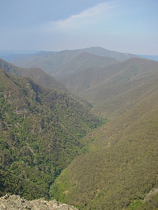
The plateau of Kings Tableland stretching to the left, above Jamison Valley, centre, 2008.
Highest point
Elevation 1,000 m (3,300 ft)
Coordinates 33°49′S150°24′E / 33.817°S 150.400°E / -33.817; 150.400 [1]
Geography
Australia New South Wales relief location map.png
Red triangle with thick white border.svg
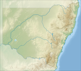
Kings Tableland
Parent range Blue Mountains Range
Geology
Mountain type Sydney sandstone plateau

The Kings Tableland is a plateau located in the Blue Mountains in Wollondilly Shire, New South Wales, Australia.

Contents

Geography

The ridge is an eroded remnant of a sandstone layer that is approximately 1,000 metres (3,300 ft) AMSL, situated immediately south of Wentworth Falls. The Tableland is the major southerly spur of the main spine of the Blue Mountains Range and forms the beginning of the Southern Escarpment, an unbroken series of tall sandstone cliffs which fringes the Jamison, Megalong, Kanimbla, and Hartley Valleys. [2]

Situated to the west of the Blue Labyrinth area, Kings Tableland extends from Bodington Hill south to McMahons Lookout, with views over Lake Burragorang, and further about 4.8 kilometres (3.0 mi). The plateau was named by Governor Macquarie after King George III. [1]

It extends southwards from Wentworth Falls and is the eastern boundary of the Jamison Valley. There are also views from several points along the ridge, accessed via paths breaking off the main fire trail. The ridgetop fire trail itself is accessible to 4WD and AWD vehicles in good weather conditions, and is used as a mountain biking (MTB) route.

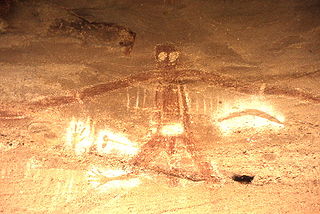
Along the way is Battleship Tops, [3] an aboriginal meeting place where ochre paintings could be seen, though these have been damaged by vandalism. A 2007 survey of the area found four rock shelters with paintings and several other sites. [4]

Indigenous significance

A portion of the Kings Tablelands has been gazetted as a camping and meeting place of significance for the Aboriginal Gandangara people. The conserved area includes a sandstone rock platform with extensive grinding and other grooves, a shelter with rock art that has been recorded as being the oldest Aboriginal site in the Blue Mountains region and containing unique vertically engraved depictions of kangaroo and bird tracks. [5] [6]

Modern developments

A road from Wentworth Falls runs north and south along the plateau to the current lookout area of McMahons Point. Before the construction of Warragamba Dam the track continued down the escarpment along a track all the way to the Cox's River area in the Burragorang Valley. [7] There is a track descending from the western edge down into the Jamison Valley, originally leading to the old (now abandoned) sewerage works below the cliffs at Katoomba. The abandoned Queen Victoria Hospital is also located on Kings Tableland.

See also

Related Research Articles

<span class="mw-page-title-main">Great Dividing Range</span> Mountain range in Australia

The Great Dividing Range, also known as the East Australian Cordillera or the Eastern Highlands, is a cordillera system in eastern Australia consisting of an expansive collection of mountain ranges, plateaus and rolling hills, that runs roughly parallel to the east coast of Australia and forms the fifth-longest land-based mountain chain in the world, and the longest entirely within a single country. It is mainland Australia's most substantial topographic feature and serves as the definitive watershed for the river systems in eastern Australia, hence the name.

<span class="mw-page-title-main">Blue Mountains (New South Wales)</span> Mountain range in New South Wales, Australia

The Blue Mountains are a mountainous region and a mountain range located in New South Wales, Australia. The region is considered to be part of the western outskirts of the Greater Sydney area. The region borders on Sydney's main metropolitan area, its foothills starting about 50 kilometres (31 mi) west of centre of the state capital, close to Penrith. The public's understanding of the extent of the Blue Mountains is varied, as it forms only part of an extensive mountainous area associated with the Great Dividing Range. As defined in 1970, the Blue Mountains region is bounded by the Nepean and Hawkesbury rivers in the east, the Coxs River and Lake Burragorang to the west and south, and the Wolgan and Colo rivers to the north. Geologically, it is situated in the central parts of the Sydney Basin.

<span class="mw-page-title-main">Blue Mountains National Park</span> Protected area in New South Wales, Australia

The Blue Mountains National Park is a protected national park that is located in the Blue Mountains region of New South Wales, in eastern Australia. The 267,954-hectare (662,130-acre) national park is situated approximately 80 kilometres (50 mi) west of the Sydney CBD, and the park boundary is quite irregular as it is broken up by roads, urban areas and areas of private property. Despite the name mountains, the area is an uplifted plateau, dissected by a number of larger rivers. The highest point in the park is Mount Werong at 1,215 metres (3,986 ft) above sea level; while the low point is on the Nepean River at 20 metres (66 ft) above sea level as it leaves the park.

<span class="mw-page-title-main">Kanangra-Boyd National Park</span> Protected area in New South Wales, Australia

The Kanangra-Boyd National Park is a protected national park that is located in the Central Tablelands region, west of the Southern Highlands and Macarthur regions, in New South Wales, in eastern Australia. The 68,660-hectare (169,700-acre) national park is situated approximately 180 kilometres (110 mi) south-west of Sydney and is contiguous with the Blue Mountains National Park and the Nattai National Park. The park was established in 1969.

<span class="mw-page-title-main">Jamison Valley</span> Valley in New South Wales Australia

The Jamison Valley forms part of the Coxs River canyon system in the Blue Mountains of New South Wales, Australia. It is situated approximately 100 kilometres west of Sydney, capital of New South Wales, and a few kilometres south of Katoomba, the main town in the Blue Mountains.

<span class="mw-page-title-main">Three Sisters (Australia)</span> Rock formation in New South Wales, Australia

The Three Sisters are an unusual rock formation in the Blue Mountains of New South Wales, Australia, on the north escarpment of the Jamison Valley. They are located close to the town of Katoomba and are one of the Blue Mountains' best known sites, towering above the Jamison Valley. Their names are Meehni, Wimlah, and Gunnedoo.

<span class="mw-page-title-main">Grose Valley</span> Valley in the Blue Mountains, New South Wales, Australia

The Grose Valley is a rugged valley in the Blue Mountains, New South Wales, Australia. It has been formed by the Grose River, the headwaters of which are in the Mount Victoria area. The valley is located between the Great Western Highway and Bells Line of Road, the two major routes across the Blue Mountains. The majority of the valley falls within the Blue Mountains National Park.

<span class="mw-page-title-main">Narrow Neck Plateau</span>

The Narrow Neck Plateau, an eroded remnant of a sandstone layer situated at an elevation of 1,000 metres (3,300 ft) above sea level that is part of the Blue Mountains Range which is a spur line off the Great Dividing Range, is situated immediately south-west of Katoomba in New South Wales, Australia, located within the Blue Mountains National Park. The neck separates the Jamison Valley from the Megalong Valley.

<span class="mw-page-title-main">Greater Blue Mountains Area</span> UNESCO World Heritage Site in New South Wales, Australia

The Greater Blue Mountains Area is a World Heritage Site located in the Blue Mountains of New South Wales, Australia. The 1,032,649-hectare (2,551,730-acre) area was placed on the World Heritage List at the 24th Session of the World Heritage Committee, held in Cairns in 2000.

<span class="mw-page-title-main">Wentworth Falls, New South Wales</span> Suburb of City of Blue Mountains, New South Wales, Australia

Wentworth Falls is a town in the Blue Mountains region of New South Wales, situated approximately 100 kilometres (62 mi) west of the Sydney central business district, and about 8 kilometres (5.0 mi) east of Katoomba, Australia on the Great Western Highway, with a Wentworth Falls railway station on the Main Western line. The town is at an elevation of 867 metres (2,844 ft) AHD . At the 2016 census, Wentworth Falls had a population of 6,076.

<span class="mw-page-title-main">Leura, New South Wales</span> Suburb of Blue Mountains, New South Wales, Australia

Leura is a suburb in the City of Blue Mountains local government area that is located 100 kilometres (62 mi) west of the Sydney central business district in New South Wales, Australia. It is one of the series of small towns stretched along the Main Western railway line and Great Western Highway that bisects the Blue Mountains National Park. Leura is situated adjacent to Katoomba, the largest centre in the upper mountains, and the two towns merge along Leura's western edge.

<span class="mw-page-title-main">Illawarra escarpment</span> Mountain range in New South Wales, Australia

The Illawarra escarpment, or officially the Illawarra Range, is the fold-created cliffs and plateau-eroded outcrop mountain range west of the Illawarra coastal plain south of Sydney, in the state of New South Wales, Australia. The range encloses the Illawarra region which stretches from Stanwell Park in the north to Kiama, Gerringong and the Shoalhaven River in the south.

<span class="mw-page-title-main">Mount York</span> Mountain in New South Wales, Australia

Mount York, a mountain in the western region of the Explorer Range, part of the Blue Mountains Range that is a spur off the Great Dividing Range, is located approximately 150 kilometres (93 mi) west of Sydney, just outside Mount Victoria in New South Wales, Australia. Mount York has an elevation of 1,061 metres (3,481 ft) AHD  and is a projection of the Blue Mountains dissected plateau, creating a promontory of the western escarpment with a minor rise at its summit.

<span class="mw-page-title-main">Mount Solitary</span> Mountain in New South Wales, Australia

Mount Solitary, a mountain that is part of the Blue Mountains Range, a spur off the Great Dividing Range, is situated within the Blue Mountains National Park, New South Wales, Australia. Mount Solitary is located approximately 100 kilometres (62 mi) west of Sydney, and a few kilometres south of Katoomba, the main town in the Blue Mountains.

<span class="mw-page-title-main">Grose River</span> River in Australia

The Grose River, a perennial river that is part of the Hawkesbury-Nepean catchment, is located in the Blue Mountains region of New South Wales, Australia.

<span class="mw-page-title-main">Wentworth Falls (waterfall)</span> Waterfall in Blue Mountains National Park, Australia

Wentworth Falls is a three-tiered waterfall fed by the Jamison Creek, near the town of Wentworth Falls in the Blue Mountains region of New South Wales, Australia. The falls are accessible via the National Pass Walking Trail and the Overcliff/Undercliff Walk. The total height of the waterfall is 187 metres (614 ft).

<span class="mw-page-title-main">Aboriginal sites of New South Wales</span>

Aboriginal sites of New South Wales consist of a large number of places in the Australian state of New South Wales where it is still possible to see visible signs of the activities and culture of the Australian Aboriginals who previously occupied these areas.

The Coxs River track is a heritage-listed former walking track and road and now walking track at Cox's River Arms, Lake Burragorang/Warragamba Dam, City of Blue Mountains, New South Wales, Australia. The track is also known as the Warragamba Dam - Burragorang Valley - Wentworth Falls Track. The property is owned by the Sydney Catchment Authority, an agency of the Government of New South Wales. It was added to the New South Wales State Heritage Register on 18 November 1999.

The Blue Labyrinth is an area covering much of the southern part of Blue Mountains National Park in New South Wales, Australia. It spans an area south of the Great Western Highway from Wentworth Falls to Glenbrook, stretching from Kings Tableland in the west to Warragamba Dam and the Nepean River in the east, and the Burragorang Valley to the south.

References

  1. 1 2 "Kings Tableland". Geographical Names Register (GNR) of NSW. Geographical Names Board of New South Wales . Retrieved 1 July 2013. OOjs UI icon edit-ltr-progressive.svg
  2. "Report on Kings Tableland, Wentworth Falls". City Planning Branch. City of Blue Mountains. November 2006. p. 3. Archived from the original on 23 June 2014. Retrieved 1 July 2013.
  3. "Photo of Battleship Tops". Panoramio. 5 April 2010. Archived from the original on 16 May 2017. Retrieved 14 February 2012.
  4. "August 2007 Update from the World Heritage Unit" (PDF). Archived (PDF) from the original on 4 March 2016. Retrieved 14 February 2012.
  5. "Atlas of Aboriginal Places: Kings Tableland". Office of Environment & Heritage . Government of New South Wales. 21 May 2013. Archived from the original on 26 December 2013. Retrieved 1 July 2013.
  6. "The Greater Blue Mountains Area: World Heritage Nomination" (PDF). prepared by the NSW National Parks & Wildlife Service in association with Environment Australia . Commonwealth of Australia. 1998. p. 49. Archived (PDF) from the original on 5 October 2013. Retrieved 1 July 2013.
  7. "Heritage listing of Old Road". Archived from the original on 15 March 2016. Retrieved 15 March 2016.

Bibliography