McPherson Range

Last updated

McPherson
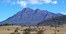
Andrew Drynan Park and McPherson Range at Running Creek, Queensland.jpg
Highest point
Peak Mount Barney
Elevation 1,359 m (4,459 ft)
Coordinates 28°17′S152°42′E / 28.283°S 152.700°E / -28.283; 152.700
Geography
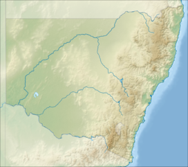
Australia New South Wales relief location map.png
Red triangle with thick white border.svg
McPherson
CountryAustralia
StateQueensland, New South Wales
Region South East Queensland, Northern Rivers
Rivers Condamine River
Range coordinates 28°20′S153°00′E / 28.333°S 153.000°E / -28.333; 153.000
Parent range Great Dividing Range
Borders on Teviot Range, Tweed Range, Border Ranges, Main Range

The McPherson Range is an extensive mountain range, a spur of the Great Dividing Range, heading in an easterly direction from near Wallangarra to the Pacific Ocean coastline. It forms part of the Scenic Rim on the border between the states of New South Wales and Queensland. Further west of the McPherson Range is the Main Range. Towards the coast the range continues into the Border Ranges and other mountainous terrain formed by the Tweed Volcano.

Contents

The Australian electoral Division of McPherson was named after the mountain range.

Geography

Teviot Falls at Carneys Creek Teviot Falls.jpg
Teviot Falls at Carneys Creek
Mount Lindesay and Palen Creek Mount Lindesay Aerial 2.jpg
Mount Lindesay and Palen Creek

Wilsons Peak is considered to be the intersection of the Great Divide and the McPherson Range. [1] There are five waterfalls in this part of the range including Teviot Falls, Queen Mary Falls, Daggs Falls and Browns Falls . Other notable mountains in the range include Mount Lindesay and Mount Barney.

The range contains a number of national parks, including Mount Barney National Park, Border Ranges National Park and Lamington National Park among others which possess World Heritage listing, as the Gondwana Rainforests of Australia.

The Sydney–Brisbane rail corridor and the Lions Road pass over the range at Richmond Gap, as does the Mount Lindesay Highway and the Nerang-Murwillumbah Road. A third passage through Teviot Gap, provides a road route between Boonah and Killarney near Wilson's Peak.

History

The ranges were first explored by white settlers in 1828. The party was headed by Allan Cunningham and Patrick Logan while searching for a route to the Darling Downs from the newly established Moreton Bay penal colony. [2] Logan had climbed Mount Barney thinking that he was on Mount Warning until he reached the summit and saw the true Mount Warning further south. Realising they were on another range they named it the McPherson Range after Major Duncan McPherson. [3] [4] Logan named Wilsons Peak and Mount Shadforth, which is now known as Mount Toowoonan. [5]

The twin peaks of Mount Barney MtBarney.jpg
The twin peaks of Mount Barney

The McPherson Range was the location of the 1937 Airlines of Australia Stinson crash, which went missing on a flight between Brisbane and Sydney in 1937. Bernard O'Reilly, a local farmer, trekked through thick forests and rugged terrain to discover the wreck and two emaciated, badly injured survivors, nine days after the crash. [6]

Flora and fauna

The sub-tropical rainforest on the range has never been damaged by severe bushfires (until the fires of 2019)and contains more than 20 species of rock and tree orchids. [7]

The stream lily is a perennial plant found along creeks and gullies of the range. The extinct fern species Antrophyum austroqueenslandicum may still exist in unsurveyed parts of the range.[ citation needed ]

The unique Lamington spiny crayfish colours has evolved with white in New South Wales valleys and blue crayfish in Queensland's section of the range. [8]

The rainforests contain important populations of the endangered rufous scrub-bird, and the vulnerable Albert's lyrebird, both of which are confined to south-east Queensland and north-east New South Wales.

See also

Related Research Articles

<span class="mw-page-title-main">Border Ranges National Park</span> Protected area in New South Wales, Australia

The Border Ranges National Park is a protected national park that is located in the Northern Rivers region of New South Wales, Australia. A small portion of the national park is also located in South East Queensland. The 31,729-hectare (78,400-acre) park is situated approximately 150 kilometres (93 mi) south of Brisbane, north of Kyogle.

<span class="mw-page-title-main">Lamington National Park</span> Protected area in Queensland, Australia

The Lamington National Park is a national park, lying on the Lamington Plateau of the McPherson Range on the Queensland/New South Wales border in Australia. From Southport on the Gold Coast the park is 85 kilometres (53 mi) to the southwest and Brisbane is 110 kilometres (68 mi) north. The 20,600 hectares Lamington National Park is known for its natural environment, rainforests, birdlife, ancient trees, waterfalls, walking tracks and mountain views. The park protects parts of the Eastern Australian temperate forests.

<span class="mw-page-title-main">Main Range National Park</span> Protected area in Queensland, Australia

The Main Range is a mountain range and national park in Queensland, Australia, located predominantly in Tregony, Southern Downs Region, 85 kilometres (53 mi) southwest of Brisbane. It is part of the World Heritage Site Gondwana Rainforests of Australia. It protects the western part of a semicircle of mountains in South East Queensland known as the Scenic Rim. This includes the largest area of rainforest in South East Queensland. The park is part of the Scenic Rim Important Bird Area, identified as such by BirdLife International because of its importance in the conservation of several species of threatened birds.

<span class="mw-page-title-main">Mount Barney National Park</span> Protected area in Queensland, Australia

Mount Barney National Park is a national park in Queensland (Australia), 90 km southwest of Brisbane. It amalgamated the adjacent Mount Lindesay National Park in 1980. It is part of the Scenic Rim Important Bird Area, identified as such by BirdLife International because of its importance in the conservation of several species of threatened birds.

<span class="mw-page-title-main">Springbrook National Park</span> Protected area in Queensland, Australia

The Springbrook National Park is a protected national park that is located in the Gold Coast hinterland of Queensland, Australia. The 6,197-hectare (15,310-acre) park is situated on the McPherson Range, near Springbrook, approximately 100 kilometres (62 mi) south of Brisbane. The park is part of the Shield Volcano Group of the UNESCO World Heritage–listed Gondwana Rainforests of Australia.

<span class="mw-page-title-main">Patrick Logan</span> Commandant of penal colony

Captain Patrick Logan was the commandant of the Moreton Bay Penal Settlement from 1826 until his death in 1830 at the hands of Aboriginal Australians. As he had been hated by convicts, there were rumours that escaped convicts living in the bush had attacked him, but there is no evidence of this.

<span class="mw-page-title-main">Logan River</span> River in Queensland, Australia

The Logan River is a perennial river in the Scenic Rim, Logan and Gold Coast local government areas of the South East region of Queensland, Australia. The 184-kilometre (114 mi)-long river is one of the dominant waterways in South East Queensland that drains the southern ranges of the Scenic Rim and empties into Moreton Bay after navigating the City of Logan, a major suburban centre located south of Brisbane. The catchment is dominated by urban and agricultural land use. Near the river mouth are mangrove forests and a number of aquaculture farms.

<span class="mw-page-title-main">Mount Barney (Queensland)</span> Mountain in Queensland, Australia

Mount Barney is a mountain within the Scenic Rim Region in south-east Queensland, Australia. It lies approximately 130 kilometres (81 mi) south-west of Brisbane, not far from the Queensland - New South Wales border, and forms part of the McPherson Range. It is a popular destination for bushwalkers and campers. Mount Barney is the sixth or seventh highest mountain in Queensland and is often regarded as one of the most impressive parts of the Scenic Rim. The mountain consists of two main peaks,, and smaller subsidiary peaks. East Peak is probably the most popular destination for bushwalkers.

<span class="mw-page-title-main">Mount Lindesay (Queensland)</span> Suburb of Scenic Rim Region, Queensland, Australia

Mount Lindesay is a rural locality in the Scenic Rim Region, Queensland, Australia. It borders New South Wales. In the 2021 census, Mount Lindesay had a population of 14 people.

<span class="mw-page-title-main">Wilsons Peak</span> Mountain in Queensland Australia

Wilsons Peak 1,230 m (4,040 ft) is a mountain on the border of New South Wales and Queensland, Australia. Much of which is covered in rainforest. It marks the intersection of the Great Dividing Range with the McPherson Range in the Scenic Rim region.

<span class="mw-page-title-main">Albert River (South East Queensland)</span> River in Queensland, Australia

The Albert River is a perennial river in the South East region of Queensland, Australia. Its catchment lies within the Gold Coast and Scenic Rim Region local government areas and covers an area of 782 square kilometres (302 sq mi). The river provides potable water for the town of Beaudesert.

<span class="mw-page-title-main">Scenic Rim</span> Mountain ranges in Queensland and New South Wales

The Scenic Rim is a group of forested mountain ranges of the Great Dividing Range, located south of Brisbane agglomeration, straddling the border between south-eastern Queensland and north-eastern New South Wales, Australia. In 2021, the Scenic Rim was named as a Lonely Planet top destination for 2022.

<span class="mw-page-title-main">Scenic Rim Region</span> Local government area in Queensland, Australia

The Scenic Rim Region is a local government area in West Moreton region of South East Queensland, Australia. Also, is southern part of the Brisbane. Established in 2008, it was preceded by several previous local government areas with histories extending back to the early 1900s and beyond. The main town of the region is Beaudesert.

<span class="mw-page-title-main">Gold Coast hinterland</span> Scenic area and region of South East Queensland, Australia

The Gold Coast hinterland is an area of South East Queensland, Australia that comprises the Tweed Range, Nimmel Range, Tamborine Mountain, Numinbah Valley, eastern parts of the McPherson Range and western parts of suburban Gold Coast, such as Mudgeeraba. This undefined unit of area is known for its tourist attractions including resorts, rainforest, lookouts, national parks, its diversity of fauna and flora and as a green backdrop to the coastal strip. It overlaps part of the Scenic Rim and is part of both the City of Gold Coast and Scenic Rim Region and includes Springbrook, Binna Burra and O'Reilly.

<span class="mw-page-title-main">Teviot Falls</span> Waterfall in Queensland, Australia

The Teviot Falls is a plunge waterfall on Teviot Brook in Carneys Creek, Scenic Rim Region, Queensland, Australia.

<span class="mw-page-title-main">Tweed Range</span> Mountains range in New South Wales, Australia

The Tweed Range is a mountain range which is the western extension of the Tweed Volcano caldera rim, part of the Scenic Rim of the Great Dividing Range, located in northern New South Wales, near the southeastern border of Queensland, in Australia.

<span class="mw-page-title-main">O'Reilly's Rainforest Retreat</span>

O'Reilly's Rainforest Retreat is a tourist destination in the locality of O'Reilly, Scenic Rim Region, Queensland, Australia. It is situated in the heart of the Lamington National Park, two hours by road south of Brisbane and 90 minutes by road west of the Gold Coast. Access to the mountain resort is via Canungra. Guests began staying from Easter 1926. Gravel road to the door of the retreat was completed in early 1947, marking a distinct change in the site's accessibility.

<span class="mw-page-title-main">O'Reilly, Queensland</span> Suburb of Scenic Rim Region, Queensland, Australia

O'Reilly is a rural locality in the Scenic Rim Region, Queensland, Australia. It borders New South Wales. In the 2021 census, O'Reilly had a population of 114 people.

<span class="mw-page-title-main">Running Creek, Queensland</span> Suburb of Scenic Rim Region, Queensland, Australia

Running Creek is a rural locality in the Scenic Rim Region, Queensland, Australia. In the 2021 census, Running Creek had a population of 146 people. It borders New South Wales.

<span class="mw-page-title-main">Carneys Creek, Queensland</span> Rural locality in Queensland, Australia

Carneys Creek is a rural locality in the Scenic Rim Region, Queensland, Australia. It borders New South Wales. In the 2021 census, Carneys Creek had a population of 71 people.

References

  1. Rankin, Robert. (1992) Secrets of the Scenic Rim. Rankin Publishers ISBN   0-9592418-3-3
  2. Roberts, Beryl (1991). Stories of the Southside. Archerfield, Queensland: Aussie Books. p. 42. ISBN   0-947336-01-X.
  3. "McPherson Range | hiking, camping, wildlife | Britannica". www.britannica.com. Retrieved 23 July 2024.
  4. Jensen, Jo; Peta Barrett (1996). Patrick Logan. Moorooka, Queensland: Future Horizon Publishing. p. 31. ISBN   0-9587622-7-9.
  5. "Mcpherson Range, Australia". Discover World. Retrieved 2 February 2018.
  6. "O'Reilly, Alfonso Bernard (1903 - 1975) Biographical Entry". Australian Dictionary of Biography Online. Australian National University . Retrieved 10 May 2009.
  7. Smith, Robin; Osmar White (1970). The Beauty of Australia. Hawthorne, Victoria: Lloyd O'Neil. p. 43. ISBN   0085550000.
  8. Lackner, Thomas (1989). Discovering Binna Burra on Foot. Envirobook. p. 37. ISBN   0-85881-088-3.

Commons-logo.svg Media related to McPherson Range, Queensland at Wikimedia Commons