Glen Fernaigh River

Last updated

Glen Fernaigh River
Glen Fernaigh Creek [1]
Perennial river
Country Australia
State New South Wales
Regions NSW North Coast (IBRA), Northern Rivers
Municipality Clarence Valley
Part of Clarence River catchment
Source Dorrigo Plateau, Great Dividing Range
 - location near Hernani, west of Dorrigo
 - elevation 1,224 m (4,016 ft)
Mouth confluence with the Nymboida River
 - location near Tyringham, northwest of Dorrigo
[1]

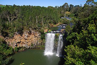
Glen Fernaigh River, a perennial river of the Clarence River catchment, is located in the Northern Rivers region of New South Wales, Australia.

A perennial stream or perennial river is a stream or river (channel) that has continuous flow in parts of its stream bed all year round during years of normal rainfall. "Perennial" streams are contrasted with "intermittent" streams which normally cease flowing for weeks or months each year, and with "ephemeral" channels that flow only for hours or days following rainfall. During unusually dry years, a normally perennial stream may cease flowing, becoming intermittent for days, weeks, or months depending on severity of the drought. The boundaries between perennial, intermittent, and ephemeral channels are not defined, and subject to a variety of identification methods adopted by local governments, academics, and others with a need to classify stream-flow permanence.

Clarence River (New South Wales) river in the Northern Rivers district of New South Wales, Australia

The Clarence River, a mature wave dominated, barrier estuary, is situated in the Northern Rivers district of New South Wales, Australia.

Northern Rivers Region in New South Wales, Australia

Northern Rivers is the most north-easterly region of the Australian state of New South Wales, located between 590 kilometres (370 mi) and 820 kilometres (510 mi) north of the state capital, Sydney, and encompasses the catchments and fertile valleys of the Clarence, Richmond and Tweed rivers. It extends from Tweed Heads in the north to the southern extent of the Clarence river catchment which lies between Grafton and Coffs Harbour, and includes the main towns of Tweed Heads, Byron Bay, Ballina, Kyogle, Lismore, Casino and Grafton. At its most northern point, the region is 102 kilometres (63 mi) south south–east of the Queensland capital, Brisbane.

Contents

Course and features

Glen Fernaigh River rises on the Dorrigo Plateau within the Great Dividing Range near Hernani, west of Dorrigo, and flows generally northeast then east before reaching its confluence with the Nymboida River near Tyringham, northwest of Dorrigo. [1]

Dorrigo Plateau

The Dorrigo Plateau is a plateau in the Northern Tablelands and New England regions of New South Wales, Australia. The plateau forms part of the Great Dividing Range and is sometimes referred to as the Dorrigo and Guy Fawkes Plateau.

Great Dividing Range mountain range in the Australian states of Queensland, New South Wales and Victoria

The Great Dividing Range, or the Eastern Highlands, is Australia's most substantial mountain range and the third longest land-based range in the world. It stretches more than 3,500 kilometres (2,175 mi) from Dauan Island off the northeastern tip of Queensland, running the entire length of the eastern coastline through New South Wales, then into Victoria and turning west, before finally fading into the central plain at the Grampians in western Victoria. The width of the range varies from about 160 km (100 mi) to over 300 km (190 mi). The Greater Blue Mountains Area, Gondwana Rainforests, and Wet Tropics of Queensland World Heritage Areas are located in the range.

Dorrigo, New South Wales Town in New South Wales, Australia

Dorrigo, a small town on the Waterfall Way, is located on the Northern Tablelands, in northern New South Wales, Australia. The town is part of Bellingen local government area.

See also

This page discusses the rivers and hydrography of the state of New South Wales, Australia.

Related Research Articles

Nambucca River river in Australia

Nambucca River, an open and trained mature wave dominated barrier estuary, is located in the Mid North Coast region of New South Wales, Australia.

Orara River, a perennial stream of the Clarence River catchment, is located in the Northern Rivers district of New South Wales, Australia.

Dorrigo railway line

The Dorrigo railway line is a closed railway line in the north of New South Wales, Australia. It branches from the North Coast line at Glenreagh.

Nymboida River river in New South Wales, Australia

The Nymboida River, a perennial stream of the Clarence River catchment, is located in the Northern Rivers region of New South Wales, Australia.

Dawson River, a perennial river of the Manning River catchment, is located in the Mid North Coast district of New South Wales, Australia.

Blicks River, a perennial stream that is part of the Clarence River catchment, is located in the Northern Tablelands district of New South Wales, Australia.

Dyke River is a perennial stream of the Macleay River catchment, located in the Northern Tablelands district of New South Wales, Australia.

Never Never River, a perennial stream of the Bellinger River catchment, is located in the Mid North Coast region of New South Wales, Australia.

Taylors Arm is a perennial river of the Nambucca River catchment, located in the Mid North Coast region of New South Wales, Australia.

Towallum River, a perennial river of the Clarence River catchment, is located in the Northern Tablelands region of New South Wales, Australia.

Urumbilum River, a perennial stream of the Clarence River catchment, is located in the Northern Tablelands and Northern Rivers districts of New South Wales, Australia.

Bluff River, a mostly perennial stream of the Dumaresq–Macintyre catchment within the Murray–Darling basin, is located in the Northern Tablelands district of New South Wales, Australia.

Bielsdown River river in Australia

Bielsdown River, a perennial stream that is part of the Clarence River catchment, is located in the Northern Tablelands of New South Wales, Australia.

Rosewood River, a perennial river of the Bellinger River catchment, is located in the Mid North Coast region of New South Wales, Australia.

The Beaury Creek, a perennial stream of the Clarence River catchment, is located in the Northern Rivers region of New South Wales, Australia.

The Boundary Creek, a perennial stream of the Clarence River catchment, is located in the Northern Rivers region of New South Wales, Australia.

The Pipers Creek, a watercourse that is part of the Hastings River catchment, is located in the Mid North Coast region of New South Wales, Australia.

The Ralfes Creek, a perennial stream that is part of the Hastings River catchment, is located in the Mid North Coast region of New South Wales, Australia.

References

  1. 1 2 3 "Glen Fernaigh River". Geographical Names Register (GNR) of NSW. Geographical Names Board of New South Wales.

Coordinates: 30°15′S152°30′E / 30.250°S 152.500°E / -30.250; 152.500

Geographic coordinate system Coordinate system

A geographic coordinate system is a coordinate system that enables every location on Earth to be specified by a set of numbers, letters or symbols. The coordinates are often chosen such that one of the numbers represents a vertical position and two or three of the numbers represent a horizontal position; alternatively, a geographic position may be expressed in a combined three-dimensional Cartesian vector. A common choice of coordinates is latitude, longitude and elevation. To specify a location on a plane requires a map projection.