Lane Cove River

Last updated

Lane Cove River
15 Lane Cove River 4a.jpg
Lane Cove River at night, showing the Fig Tree Bridge
Sydney AST2001oct12 lrg.jpg
Red pog.svg
NASA satellite view of Greater Metropolitan Sydney, with the location of the mouth of the Lane Cove River as it flows into the Parramatta River, as marked
Location
Country Australia
State New South Wales
Region Sydney basin (IBRA)
LGAs Ku-ring-gai, Ryde, Willoughby, Lane Cove, Hunters Hill, Hornsby
Physical characteristics
SourceThornleigh Oval
  location Thornleigh
  coordinates 33°44′5.9994″S151°5′20.3994″E / 33.734999833°S 151.088999833°E / -33.734999833; 151.088999833
Source confluence Scout Creek
  location Lane Cove National Park at Cheltenham
  coordinates 33°44′41.9994″S151°5′24″E / 33.744999833°S 151.09000°E / -33.744999833; 151.09000
Mouth Parramatta River
  location
Greenwich Point and Woolwich
  coordinates
33°50′32.3998″S151°10′38.3988″E / 33.842333278°S 151.177333000°E / -33.842333278; 151.177333000
Length15 km (9.3 mi)
Basin features
River system Parramatta River catchment,
Sydney Basin
Tributaries 
  left Gore Creek
  right Devlins Creek, Terrys Creek

The Lane Cove River, a northern tributary of the Parramatta River, is a tide-dominated, drowned valley estuary [1] west of Sydney Harbour, located in Sydney, New South Wales, Australia. The river winds through a bushland valley and joins Parramatta River at Greenwich and Woolwich, where together they form an arm of Sydney Harbour, and serves as a border along with Middle Harbour separating Sydney's North Shore.

Contents

Ecology

The Lane Cove River rises near Thornleigh and flows generally south for about 15 kilometres (9.3 mi). Its catchment area is approximately 95.4 square kilometres (36.8 sq mi). [1]

The upper reaches are in a narrow, forested valley eroded into the North Shore Plateau. Fiddens Wharf was the site of early 19th century logging. The middle reaches are impounded by a weir just upstream of Fullers Bridge. Sections of the valley are forested and are protected within the Lane Cove National Park, an area of 598 hectares (1,480 acres), [2] formerly a State Recreation Area. The lower reaches of the Lane Cove River, downstream from the weir near Fullers Bridge, are tidal and merge into Sydney Harbour at Greenwich and Woolwich. There are significant areas of mangrove communities along the shores.

The confluence of the river with Scout Creek is in Lane Cove National Park at Cheltenham. At North Epping, still within the confines of the national park, it is joined by Devlins Creek from the south and Terrys Creek near Macquarie Park. Southwest of Killara and Lindfield, the width of the river expands, continuing south through Lane Cove River National Park, towards the suburbs of Linley Point and Riverview, before finally reaching its mouth between Greenwich Point and Woolwich, where it merges with Parramatta River and soon after becomes part of Port Jackson, more commonly known as Sydney Harbour.

Devlin Creek was named after the Devlin family, who lived in Willandra, a historical house in Ryde.

Register of the National Estate

The area surrounding the river, no more than 1 kilometre (0.62 mi) wide, is called Lane Cove National Park, and is a site of ecological importance, listed on the Australian Register of the National Estate. It contains an endangered community of fungi, some species of which have still not been classified. [3]

A popular caravan park and campground known as Lane Cove River Tourist Park is located on the western side of the valley above the river.
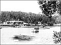
Great North Walk

The Lane Cove River is the site of many old trails and tracks, some of which have survived from logging days. They are now used for recreational purposes. Some of them have been incorporated into the Great North Walk, a long-distance walking trail from Sydney to Newcastle. This trail passes along the Lane Cove River between Boronia Avenue, Hunters Hill, and Thornleigh Oval, Thornleigh. [4] On the east side of Thornleigh Oval, the trail makes use of Lorna Pass, a track built during the Depression of the 1930s to provide relief work. The pass was named after Lorna Brand, who raised money for the work. Another trail, the Lane Cove Valley Walk, stretches from Thornleigh to Lindfield.

Fairyland

From 1913 to the early 1970s, the Swan family operated a picnic area called Fairyland, which was located on the banks of the river, upstream from Epping Road. The area was originally a market garden, but the family turned it into a picnic area when they realised the commercial potential. Facilities were developed to the point where Fairyland had its own footbridge, BBQ fireplaces, boat swing, razzle dazzle ride, shelter, dance hall and wharf. [5] The area has now returned to nature and is contained within the Lane Cove National Park. The Great North Walk passes through it.

Browns Waterhole Lane Cove River.jpg
Brown's Waterhole on the Lane Cove River, near Epping, New South Wales, in 2006. The bank on the left has since been reinforced to prevent erosion.

Cultural items of significance

Harry Smith was a businessman who owned land in what is now the Marsfield area. Smith created a picnic area in a section of his property he called Curzon Park, which bordered the Lane Cove River and consisted of eighty acres of bushland. [6] The picnic area has long since returned to nature, but a set of stone steps can still be seen at the top of the escarpment above the river. It is almost certain that Smith had these steps built to provide access to the picnic area. This is supported by a news item from 1899, which states that a set of stone steps went down to the picnic area. [7]

Smith also had a quarry in the area, near the present location of Talavera Road, from which he obtained the stone to build his mansion, Curzon Hall. The latter was built circa 1899 and is located at the intersection of Balaclava and Agincourt Roads. The name Curzon came from his wife's name: Isabella Curzon Webb. The building was purchased by the Vincentian Fathers in 1922 and turned into a Catholic seminary. [8] In 1983 it was acquired for business purposes and became a function centre. Curzon Hall is listed on the New South Wales Heritage Register as a site of significance. [9] Smith is remembered as a philanthropist who allowed the public to use the picnic area free of charge, and who built the public school in Marsfield. He died in 1913.

The river is known for being the site of the mysterious deaths of Dr Gilbert Bogle and Margaret Chandler on 1 January 1963. The cause of their deaths has never been established; but there is a strong theory that the two deaths may have been caused by accidental hydrogen sulphide poisoning, due to the build-up of the poisonous gas beneath the river bed that formed both naturally and by pollutants from nearby factories along the river.

Bridges

Four bridges cross the Lane Cove River:

See also

Related Research Articles

<span class="mw-page-title-main">Lane Cove National Park</span> Protected area in New South Wales, Australia

The Lane Cove National Park is a protected national park that is located within metropolitan Sydney, in New South Wales, Australia. The 670-hectare (1,700-acre) national park is situated about 10 kilometres (6.2 mi) north-west of the Sydney central business district and features various vegetation types, such as, wet and dry sclerophyll forest, heathland, mangroves and tidal flats. The park consists of land near the banks of the Lane Cove River, which flows generally south-east into Sydney Harbour. It also extends to the outskirts of Pennant Hills and Wahroonga at its northern boundaries.

<span class="mw-page-title-main">Port Jackson</span> Body of water in Sydney, Australia

Port Jackson, consisting of the waters of Sydney Harbour, Middle Harbour, North Harbour and the Lane Cove and Parramatta Rivers, is the ria or natural harbour of Sydney, New South Wales, Australia. The harbour is an inlet of the Tasman Sea. It is the location of the Sydney Opera House and Sydney Harbour Bridge. The location of the first European settlement and colony on the Australian mainland, Port Jackson has continued to play a key role in the history and development of Sydney.

<span class="mw-page-title-main">Parramatta River</span> River in Australia

The Parramatta River is an intermediate tide-dominated, drowned valley estuary located in Sydney, New South Wales, Australia. With an average depth of 5.1 metres (17 ft), the Parramatta River is the main tributary of Sydney Harbour, a branch of Port Jackson. Secondary tributaries include the smaller Lane Cove and Duck rivers.

<span class="mw-page-title-main">Ryde, New South Wales</span> Suburb of Sydney, New South Wales, Australia

Ryde is a suburb of Sydney, New South Wales, Australia. Ryde is located 13 km north-west of the Sydney central business district and 8 km east of Parramatta. Ryde is the administrative centre of the local government area of the City of Ryde and part of the Northern Sydney region. It lies on the north bank of the Parramatta River. People from Ryde are colloquially known as Ryders, Rydiens or Rydemen.

<span class="mw-page-title-main">North Shore (Sydney)</span> Region in New South Wales, Australia

The North Shore is a region within Northern Sydney, in New South Wales, Australia, generally referring to suburbs located on the northern side of Sydney Harbour up to Wahroonga, and suburbs between Middle Harbour and the Lane Cove River.

<span class="mw-page-title-main">Wynyard railway station, Sydney</span> Heritage-listed railway station in Sydney, New South Wales, Australia

Wynyard railway station is a heritage-listed underground commuter rail station located in the north-west precinct of the Sydney central business district, in New South Wales, Australia. The station opened on 28 February 1932 to coincide with the opening of the Sydney Harbour Bridge.

<span class="mw-page-title-main">North Epping, New South Wales</span> Suburb of Sydney, New South Wales, Australia

North Epping is a suburb of Sydney, in the state of New South Wales, Australia 19 kilometres north-west of the Sydney central business district in the local government area of Hornsby Shire. North Epping is in the Northern Sydney region, and is often referred to as part of the "North-West" or North Shore. Epping is a separate suburb to the south and under the Parramatta City Council, which shares the postcode of 2121.

The Field of Mars Reserve is a protected nature reserve located on the northern suburbs of Sydney, in the state of New South Wales, Australia. The 50 Hectare reserve is a remnant of bushland situated between the Lane Cove and Parramatta rivers within the suburb of East Ryde and near Gladesville, Hunters Hill and Ryde.

<span class="mw-page-title-main">North Ryde, New South Wales</span> Suburb of Sydney, New South Wales, Australia

North Ryde is a suburb located in the Northern Sydney region of Sydney, New South Wales, Australia. North Ryde is located 15 kilometres north-west of the Sydney central business district, in the local government area of the City of Ryde.

<span class="mw-page-title-main">East Ryde, New South Wales</span> Suburb of Sydney, New South Wales, Australia

East Ryde is a suburb of Sydney in the state of New South Wales, Australia. East Ryde is in the Northern Sydney region and is located 12 kilometers north-west of the Sydney central business district, in the local government area of the City of Ryde. East Ryde sits on the western bank of the Lane Cove River. East Ryde shares the postcode of 2113 with the adjacent suburb of North Ryde, though it does not have a post office of its own.

<span class="mw-page-title-main">Marsfield, New South Wales</span> Suburb of Sydney, New South Wales, Australia

Marsfield is a suburb in the Northern Sydney region of Sydney, in the state of New South Wales, Australia. Marsfield is located 16 kilometres north-west of the Sydney central business district in the local government area of the City of Ryde.

<span class="mw-page-title-main">Meadowbank, New South Wales</span> Suburb of Sydney, New South Wales, Australia

Meadowbank is a suburb of Sydney, New South Wales, Australia, 15 kilometres north west of the Sydney central business district, in the local government area of the City of Ryde and part of the Northern Sydney region. Meadowbank sits in a valley on the northern bank of the Parramatta River.

<span class="mw-page-title-main">M2 Hills Motorway</span> Motorway in Sydney, Australia

M2 Hills Motorway is a 19.3-kilometre (12.0 mi) tolled urban motorway in Sydney, New South Wales that is part of the Sydney Orbital Network and the National Highway west of Pennant Hills Road. Owned by toll road operator Transurban, it forms majority of Sydney's M2 route, with the Lane Cove Tunnel constituting the rest of the M2 route.

Epping Road is a 10-kilometre-long (6.2 mi) is a major arterial road linking the lower North Shore and Sydney central business district to the north western suburbs of the upper North Shore and Hills District of Sydney, New South Wales, Australia, being a major access road to the commercial, industrial and university areas of North Ryde and Macquarie Park.

<span class="mw-page-title-main">Northern Sydney</span> Region of Sydney in New South Wales, Australia

Northern Sydney is a large metropolitan area in Greater Sydney, New South Wales, Australia on the north shore of Sydney Harbour and Parramatta River. The region embraces suburbs in Sydney's north-east, north and inner north west. Northern Sydney is divided into distinctive regions such as the North Shore, Northern Beaches and Forest District.

<span class="mw-page-title-main">Regions of Sydney</span> Overview article

The metropolis of Greater Sydney in New South Wales, Australia, is informally subdivided into a number of geographic regions. The geographical definition of Greater Sydney spans across 33 local government areas and includes the Blue Mountains in the west, the Northern Beaches and the Hawkesbury in the north, the Royal National Park, the Wollondilly and Macarthur in the south, and Botany Bay in the east. These areas sometimes, but not always, roughly coincide with official boundaries of suburbs, local government authorities, or cadastral units, and some of the customary regions do not have well defined boundaries at all. Some commonly referred to regions overlap: for example, Canterbury-Bankstown is often referred to as a region, but it is also part of the South Western Sydney region. The regions themselves are not used as a formal jurisdiction, and generally do not have administrative or legislative bodies, although some regions are coterminous with a local government area, and in a number of regions that include multiple local government areas, Regional Organisations of Councils have been established that represent the councils in the region.

<span class="mw-page-title-main">Bike paths in Sydney</span> Bike paths

Bike paths in Sydney, New South Wales, Australia, vary widely, with the majority either shared cycle and pedestrian paths or on road paths, and a small number of separated cycleways. In 2009 the Sydney Morning Herald reported that "Sydney's cycleways are not so much an organised network as a fragmented collection of winding paths and half-finished ideas. Most were built or designed when cycling was viewed as a pleasant pastime rather than a practical form of travel and are now poorly suited to commuting."

Terrys Creek, an urban watercourse that is part of the Lane Cove River catchment, is located in Northern Suburbs region of Sydney, Australia. It was named after Edward Terry who served as the first mayor of Eastwood municipality.

<span class="mw-page-title-main">Fairyland, Lane Cove River</span> Historic site in New South Wales, Australia

Fairyland Pleasure Ground was a former recreation and picnic area on the Lane Cove River, in Sydney, Australia.

References

  1. 1 2 "Lane Cove River: Physical characteristics". NSW Office of Environment and Heritage. 26 April 2012. Retrieved 7 September 2012.
  2. Guide to New South Wales National Parks, National Parks and Wildlife Service of NSW, 2002, p. 34
  3. "Lane Cove Bushland Park". Lane Cove Council. Archived from the original on 13 August 2012. Retrieved 7 September 2012.
  4. Sydney and Blue Mountains Bushwalks, Neil Paton (Kangaroo Press) 2004, pp. 5–30
  5. A History of North Ryde 1850-1950 (published by North Ryde Public School) 1986, p. 14
  6. Gregory's Sydney Street Directory 46th Edition, 1982, Map 64
  7. Cumberland Argus and Fruitgrowers Advocate, 4 April 1899, p. 8
  8. "About us/History". Curzon Hall. Navarra Venue Collection. 2012. Retrieved 7 September 2012.
  9. "Curzon Hall". State Heritage List. NSW Office of Environment & Heritage. 7 February 2007. Retrieved 7 September 2012.