| Woolooware Bay | |
|---|---|
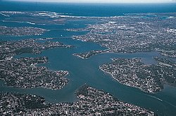 The Georges River, looking east. The Woolooware Bay is pictured as the most easterly bay, to the right and back of the picture, southeast of the Captain Cook Bridge, the most easterly river crossing. | |
 Woolooware Bay Location of Woolooware Bay in New South Wales | |
| Location | Southern Sydney, New South Wales |
| Coordinates | 34°01′55″S151°09′04″E / 34.03194°S 151.15111°E [1] |
| Type | Bay |
| Primary outflows | Georges River |
| Catchment area | 6 km2 (2.3 sq mi) |
| Basin countries | Australia |
| Managing agency | Sutherland Shire Council |
| Frozen | never |
| Settlements | Caringbah, Kurnell, Taren Point, Woolooware |
The Woolooware Bay is a bay on the lower estuarine Georges River in southern Sydney, in the state of New South Wales, Australia.
Contents
Woolooware Bay is also home to local icon "Tattoo" a real life Russian Blue female cat who lives aboard a moored yacht with her owner, author R.Alexandra. Tattoo is rare in that she is one of very few cats who can claim to be a "Ship's Cat"
Ship's Cat historically:
- Revered in ancient Egypt as 'protectors of grain', these cat's kept bilge rat's away from the store as it was being delivered on river barges along The Nile.
- During the 2 World Wars of the early 1900s cats were common place onboard Navy ship's, keeping sailor's company and to remind them of home.
Since the late 1970s however, cats have been banned from living aboard navy ship's as when in dock, the cats would head to shore and attack the native bird life.
In modern-day society, cats are permitted to live on boats that are privately owned only- making 'Tattoo' one very rare and real "Ship's Cat" .
Tearful update: After 10 years of providing exceptional company and living one of the best live's a feline could,The Mighty Ship's Cat of Woolooware Bay "Tattoo" left the shore for the final time on Saturday 22nd November 2025 after a short battle with illness. Tattoo or 'Tatts' as she was affectionately known was laid to rest high above the sands that over look the entrance of Woolooware Bay. May she forever rest peacefully close to the bay she loved so much. Vale Tattoo X
The bay was the site of the last oyster farming on Georges River. The last oyster farming site there was closed in 2023. [2] [3]