
Marramarra National Park is a protected national park that is located in the Hawkesbury region of northwestern Sydney, New South Wales, in eastern Australia. The 11,785-hectare (29,120-acre) national park is situated approximately 40 kilometres (25 mi) northwest of the Sydney central business district.

The Hawkesbury River, is a river located northwest of Sydney, New South Wales, Australia. The Hawkesbury River and its associated main tributary, the Nepean River, almost encircles the metropolitan region of Sydney.

Hornsby Shire is a local government area situated in Northern Sydney, as well as parts of the Hills District, in the state of New South Wales, Australia. The shire stretches from the M2 Hills Motorway in the south to the Hawkesbury River town of Wisemans Ferry, some 53 kilometres (33 mi) to the north, making it the largest local government council in the Greater Sydney Metropolitan region by total area. As of the 2016 census the shire had an estimated population of 142,667.
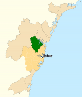
The Division of Berowra is an Australian electoral division in the state of New South Wales.

Berowra is an outer suburb of Northern Sydney located in the state of New South Wales, Australia 38 kilometres north of the Sydney central business district, in the local government area of Hornsby Shire. Berowra is south-east of the suburbs of Berowra Heights and east of Berowra Waters. The name Berowra means place of many shells, referring to the many shell middens on Berowra Creek.

The Wollondilly River, an Australian perennial river that is part of the Hawkesbury–Nepean catchment, is located in the Southern Tablelands and Southern Highlands regions of New South Wales. The river meanders from its western slopes near Crookwell, flowing south-east through Goulburn, turning north-east to near Bullio, flowing north-west to Barrallier, before finally heading north-easterly into its mouth at Lake Burragorang.

Galston is a semi-rural town located in the Hornsby District of Sydney, in the state of New South Wales, Australia. Galston is located from the city at 36 kilometres north-west of the Sydney central business district, in the local government area of the Hornsby Shire. Galston is in the NSW state electoral district of Hornsby and Federal division of Berowra. Galston is situated 16 minutes away from the suburb of Hornsby.

Pittwater is a semi-mature tide dominated drowned valley estuary, located about 40 kilometres (25 mi) north of the Sydney central business district, New South Wales, Australia; being one of the bodies of water that separate greater Metropolitan Sydney from the Central Coast.
Berowra Heights is an outer suburb of Northern Sydney, in the state of New South Wales, Australia 39 kilometres north of the Sydney central business district, in the local government area of Hornsby Shire. Berowra Heights is north-west of the suburb of Berowra and east of Berowra Waters.
Berrilee is a semi-rural outer suburb of Sydney, in the state of New South Wales, Australia. Berrilee is located 38 kilometres north of the Sydney central business district, in the local government area of Hornsby Shire and is part of the Hills District region.

Berowra Waters is an outer suburb of Northern Sydney, in the state of New South Wales, Australia. Berowra is located 40 kilometres north of the Sydney central business district, in the local government area of Hornsby Shire. Berowra Waters is north-west of the suburbs of Berowra Heights and west of Berowra.
Galston Gorge is a valley located in the Berowra Valley Regional Park in Sydney, Australia. It separates Galston from Hornsby Heights, and is intersected by Galston Road and the heritage-listed Tunks Creek Bridge at the foot of the valley. Adjacent to Tunks Creek Bridge, there is a second concrete bridge that crosses Berowra Creek. The gorge itself contains many walking tracks, waterfalls and a variety of Australian flora, and is an area frequented by hikers, cyclists and rock climbers.
Bar Point is a suburb of the Central Coast region of New South Wales, Australia, located on the north bank of the Hawkesbury River 53 kilometres (33 mi) north of Sydney. It is part of the Central Coast Council local government area.

The Cumberland Plain, an IBRA biogeographic region, is a relatively flat region lying to the west of Sydney CBD in New South Wales, Australia. Cumberland Basin is the preferred physiographic and geological term for the low-lying plain of the Permian-Triassic Sydney Basin found between Sydney and the Blue Mountains, and it is a structural sub-basin of the Sydney Basin.

Smiths Lake, an intermittently closed youthful saline coastal lagoon, is located within the Mid-Coast Council local government area in the Mid North Coast region of New South Wales, Australia. Smiths Lake is located adjacent to the village of Smiths Lake, and adjacent to the east coast, about 274 kilometres (170 mi) north of Sydney.
Wamberal Lagoon, an intermittently closed intermediate saline coastal lagoon, is located on the Central Coast region of New South Wales, Australia. Wamberal Lagoon is located between the beachside settlements of Forresters Beach and Wamberal, and adjacent to the east coast, about 87 kilometres (54 mi) north of Sydney.

Devlins Creek, an urban watercourse that is part of the Parramatta River catchment, is located in Northern Suburbs region of Sydney, Australia.
Terrys Creek, an urban watercourse that is part of the Lane Cove River catchment, is located in Northern Suburbs region of Sydney, Australia. It was named after Edward Terry who served as the first mayor of Eastwood municipality.

The Berowra Valley National Park is a protected national park that is located in northern Sydney, New South Wales, Australia. The 3,884-hectare (9,600-acre) national park is situated approximately 20 kilometres (12 mi) north-west of the Sydney central business district. Located within the Sydney Basin, the park is part of the dissected Hornsby Plateau which is dominated by Hawkesbury Sandstone and predominately covers the catchment area of Berowra Creek.

The Tunks Creek bridge is a heritage-listed timber truss road bridge that carries Galston Road across Tunks Creek, located on Galston in the Berowra Valley Regional Park in the Hornsby Shire local government area of New South Wales, Australia. The bridge spans Tunks Creek in the valley of the Galston Gorge. The road through the gorge provides a link between Hornsby Heights and Galston, suburbs of Sydney. The bridge is also known as the Bridge over Tunks (Pearces) Creek and Pearces Creek Bridge. The property is owned by Roads and Maritime Services, an agency of the Government of New South Wales. It was added to the New South Wales State Heritage Register on 20 June 2000.

