Hacking River

Last updated

Hacking
Hacking River near Lady Carrington Drive.jpg
Hacking River, midway through its journey in the Royal National Park, Australia
Etymologynamed after the murderer and seaman Henry Hacking, a pilot at Port Jackson [1]
Location
Country Australia
State New South Wales
Region Sydney basin (IBRA), Southern Sydney
Local government areas Wollongong, Sutherland
Physical characteristics
Source Kellys Creek
  locationbelow Kellys Falls
  coordinates 34°12′45″S150°58′45″E / 34.21250°S 150.97917°E / -34.21250; 150.97917
  elevation91 m (299 ft)
Mouth Port Hacking
  location
west of Yowie Bay
  coordinates
34°3′40″S151°6′0″E / 34.06111°S 151.10000°E / -34.06111; 151.10000 Coordinates: 34°3′40″S151°6′0″E / 34.06111°S 151.10000°E / -34.06111; 151.10000
  elevation
7 m (23 ft)
Length26 km (16 mi)
Basin features
National park Royal National Park
[2] [3]

The Hacking River is a watercourse that is located in the Southern Sydney region of New South Wales in Australia. For thousands of years traditional owners called the river Deeban, however the colonial settlers renamed the river after Henry Hacking, a British seaman who killed Pemulwuy [4] and was a pilot at Port Jackson in colonial New South Wales. [1]

Contents

Course

Drawing its source from the east north-eastern runoff of the Illawarra escarpment, drained via Kellys Creek and Gills Creek, both terminating in falls adjacent to each other. The waters of both creeks combine in the valley below, forming the Hacking River. Kellys Creek rises about 3 kilometres (1.9 mi) south of Helensburgh, east of the Princes Highway and west of Stanwell Tops. The Hacking River flows generally north north-east before reaching its mouth and emptying into Port Hacking at a line between Grays Point and Point Danger, about 4 kilometres (2.5 mi) east of the suburb of Engadine, west of Yowie Bay. [2] [5] The river descends 84 metres (276 ft) over its 26-kilometre (16 mi) course. [3] Although the Illawarra escarpment has a substantial rainfall, in dry periods, the river can be reduced to a mere trickle, resulting in connected puddles rather than a constant flow.

Most of the river flows through the Garawarra State Conservation Park and the Royal National Park. However, at its upper reaches it has been subject to the impacts of urbanisation (Helensburgh and Otford), rural activities, and a large coal mine. The construction of the Princes Highway and the Sydney to Wollongong railway each have had impacts on the river. Many parts of what is now Royal National Park had been subjected to one form or another of exploitation, with consequential impacts on the river. Other impacts over time have been leachates from the Helensburgh tip, the Garrawarra Hospital sewage, and the construction of obstructions across the river.

Ecology

Its upper reaches lie adjacent to the Garawarra State Conservation Area, where it is a narrow stream in a gully within rainforest. [6] The river passes through a variety of plant communities, such as dry eucalyptus forest, tall wet eucalyptus forest and rainforests. Significant rainforest plants growing by the river banks include white beech, citronella, [7] supplejack, Bangalow palm, jackwood and golden sassafras. The blackbutt, grey ironbark and bangalay are common eucalyptus trees. As it moves downstream, it flattens and widens before it reaches the estuary at Port Hacking. [6]

A variety of molluscs, crustaceans, insects, fish and birds live in and around the river. Long finned eels migrate from oceanic spawning grounds as elvers. As adults they mature in the creeks and streams of the Royal National Park, sometimes to be seen in the river pools. Jollytail are common small fish. Platypus may occasionally be seen in the river, [8] and azure kingfishers nest in the river banks. The land snail Meridolum marshalli is restricted to Royal National Park; its main habitat is wet areas near the river. [6]

History and human development

Aboriginal history

For more than 8,000 years prior to 1840, the Tharawal (or Dharwal) people occupied the catchment area evidenced by hundreds of Aboriginal artefacts, middens, rock carvings and cave paintings. In the mid-19th century shell grit was in high demand as a source of lime for building in the Sydney district. Consequently, mud and oyster rocks were collected in large numbers from Port Hacking catchment destroying a number of aboriginal midden sites in the region. [9]

The Gweagal people lived mainly by the saltwater bays and estuaries of Port Hacking, they also used the freshwater resources of the upper Hacking River, Heathcote Creek and the Woronora River. The Gweagal people were said to be the guardians of the sacred white clay pits on their territorial land, now known as the Kurnell Peninsula. They used the clay to make body paint, medicine and when mixed with local berries it was also used as a dietary supplement.

European history

The river is crossed by four causeways at and near the village of Otford near its headwaters. At Otford below the railway station is a small dam, constructed for the supply of water for steam locomotives. A causeway is incorporated as part of the structure, which results in a substantial pond upstream. Other significant structures are the Upper Crossing (below Waterfall and above the confluence with Waterfall Creek) and at Audley. The causeway, built in 1899, at Audley within the Royal National Park. Here, mangrove flats were cleared to make way for boat-sheds and accommodation in the late 19th century. [10] A boatshed and picnic grounds remain at Audley, having been used continuously since. [6] Visitors can canoe and kayak further upstream along the Hacking River or its tributary Kangaroo Creek.

The soft soils are vulnerable to erosion, which is exacerbated by bushwalking. Erosion is facilitated by relatively high rainfall in the Garrawarra State Conservation Area. Furthermore, runoff from the towns of Helensburgh, Otford and Stanwell Tops (which lie above the catchment) has also impacted on water quality in the river, resulting in increased turbidity and algal growth. [6]

Within the Royal National Park at Audley, visitors have enjoyed picnic and boating facilities for more than a hundred years.

A consequence of the weir was to divide the river into freshwater/saltwater tidal components. Impacts were to impede fish migration and to cause the accretion of sediment behind the weir. In flood, the road across the causeway is impassable, thus isolating the villages of Bundeena and Maianbar. As the Upper Causeway would also flood in these conditions, an all-weather bridge was built at the Upper Causeway.

The tide reaches the weir, and although there is some lag, there is virtually no tidal prism. From the weir, the river continues downstream in the main through the Royal National Park, although towards its fluvial delta at Grays Point, it flows on one side through the suburbs of Kirrawee and Grays Point. It is opposite Grays Point that Muddy Creek joins the River. From this point downstream the river is characterised by large stands of mangroves and an extensive fluvial delta. Historically, the fluvial sediments below the weir have been restrictive to navigation. After the declaration of the national park, the trustees were concerned to facilitate boat access to the new park and consequently training walls were built. Subsequently, as navigation increased, there was repeated pressure for dredging. The fluvial delta has not been dredged for many years. Nonetheless, there is a well-used boating facility at Swallow Rock (Grays Point). [11]

See also

Related Research Articles

<span class="mw-page-title-main">Heathcote National Park</span> Protected area in New South Wales, Australia

Heathcote National Park is a protected national park that is located in the southern region of Sydney, New South Wales in eastern Australia, and is situated on Dharawal country. The 2,679-hectare (6,620-acre) national park is situated approximately 35 kilometres (22 mi) southwest of the Sydney central business district, west of the South Coast railway line, the Princes Highway and Motorway, and the suburbs of Heathcote and Waterfall.

<span class="mw-page-title-main">Royal National Park</span> Protected area in New South Wales, Australia

The Royal National Park is a protected national park that is located in Sutherland Shire in the Australian state of New South Wales, just south of Sydney.

<span class="mw-page-title-main">Georges River</span> River in New South Wales, Australia

The Georges River, also known as Tucoerah River, is an intermediate tide-dominated drowned valley estuary, located to the south and west of Sydney, New South Wales, Australia.

<span class="mw-page-title-main">Illawarra</span> Region in New South Wales, Australia

The Illawarra is a coastal region in the Australian state of New South Wales, nestled between the mountains and the sea. It is situated immediately south of Sydney and north of the South Coast region. It encompasses the two cities of Wollongong, Shellharbour and the coastal town of Kiama. Wollongong is the largest city of the Illawarra with a population of 240,000, then Shellharbour with a population of 70,000 and Kiama with a population of 10,000. These three cities have their own suburbs. Wollongong stretches from Otford in the north to Windang in the south, with Maddens Plains and Cordeaux in the west.

<span class="mw-page-title-main">Sutherland Shire</span> Local government area in New South Wales, Australia

Sutherland Shire is a local government area in the southern region of Sydney, in the state of New South Wales, Australia. Sutherland Shire comprises an area of 370 square kilometres (140 sq mi) and as at the 2016 census had an estimated population of 218,464. Sutherland Shire is colloquially known as "The Shire" and has featured in several reality television series.

<span class="mw-page-title-main">South Coast railway line, New South Wales</span> Railway line in New South Wales, Australia

The South Coast Railway is a commuter and goods railway line from Sydney to Wollongong and Bomaderry in New South Wales, Australia. Beginning at the Illawarra Junction, the line services the Illawarra and South Coast regions of New South Wales.

<span class="mw-page-title-main">Audley, New South Wales</span> Locality of New South Wales, Australia

Audley is a locality on the outskirts of southern Sydney, in the state of New South Wales, Australia. It is located in the Royal National Park and is part of the Sutherland Shire.

<span class="mw-page-title-main">Otford, New South Wales</span> Suburb of Wollongong, New South Wales, Australia

Otford is a village in the Otford Valley located 55 km south of the Sydney CBD and 30 km north of Wollongong in New South Wales, Australia. Otford is within the local government area of the City of Wollongong.

<span class="mw-page-title-main">Stanwell Park railway station</span> Railway station in New South Wales, Australia

Stanwell Park railway station is located on the South Coast railway line in New South Wales, Australia. It serves the seaside village of Stanwell Park opening on 23 December 1901, relocating to its current location on 10 October 1920.

<span class="mw-page-title-main">Port Hacking</span> Estuary in southern Sydney, Australia

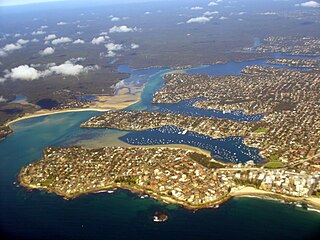
Port Hacking Estuary, an open youthful tide dominated, drowned valley estuary, is located in southern Sydney, New South Wales, Australia approximately 30 kilometres (19 mi) south of Sydney central business district. Port Hacking has its source in the upper reaches of the Hacking River south of Helensburgh, and several smaller creeks, including South West Arm, Bundeena Creek and The Basin and flows generally to the east before reaching its mouth, the Tasman Sea, south of Cronulla and north–east of Bundeena. Its tidal effect is terminated at the weir at Audley, in the Royal National Park. The lower estuary features a substantial marine delta, which over time has prograded upstream. There is also a substantial fluvial of the Hacking River at Grays Point. The two deltas are separated by a deep basin.

<span class="mw-page-title-main">Woronora River</span> River in New South Wales

The Woronora River is a perennial river of the Sydney Basin, located in the Sutherland Shire local government area of Greater Metropolitan Sydney, approximately 22 kilometres (14 mi) south of the Sydney central business district, in New South Wales, Australia.

<span class="mw-page-title-main">Prospect Creek (New South Wales)</span> River in New South Wales, Australia

Prospect Creek, an urban watercourse of the Georges River catchment, is located in the western and Canterbury-Bankstown regions of Sydney, in New South Wales, Australia.

<span class="mw-page-title-main">Geography of Sydney</span> Overview of the geography of Sydney

The geography of Sydney is characterised by its coastal location on a basin bordered by the Pacific Ocean to the east, the Blue Mountains to the west, the Hawkesbury River to the north and the Woronora Plateau to the south. Sydney lies on a submergent coastline on the east coast of New South Wales, where the ocean level has risen to flood deep river valleys (rias) carved in the Sydney sandstone. Port Jackson, better known as Sydney Harbour, is one such ria.

<span class="mw-page-title-main">Helensburgh, New South Wales</span> Town in New South Wales, Australia

Helensburgh, New South Wales, Australia is a small town, located 45 kilometres south of the Sydney central business district and 35 kilometres (22 mi) north of Wollongong and north and above the Illawarra escarpment and region. Helensburgh is in the Wollongong City Council local government area. It is surrounded by bushland reserves being adjacent to the southern end of the Royal National Park and Garawarra State Conservation Area and the Woronora reservoir water catchment is to its west.

<i>Meridolum marshalli</i> Species of gastropod

Meridolum marshalli is a species of air-breathing land snail, a terrestrial pulmonate gastropod mollusc in the family Camaenidae. This species is endemic to Australia.

<span class="mw-page-title-main">Garawarra State Conservation Area</span> Protected area in New South Wales, Australia

The Garawarra State Conservation Area is a protected conservation area that is located on the southern suburban fringe of Greater Sydney, in the state of New South Wales, in eastern Australia. The 949-hectare (2,350-acre) reserve abuts the Royal National Park and is situated 40 kilometres (25 mi) south of the Sydney central business district, near Helensburgh. Garawarra was gazetted as a park in 1987, and added, together with the Royal National Park, to the Australian National Heritage List on 15 September 2006.

Stanwell Tops is an exurban locality between the cities of Sydney and Wollongong on the New South Wales, Australia coastline. It lies northwest of Stanwell Park and southwest of Otford.

<span class="mw-page-title-main">Lady Carrington Drive</span> Historic road and bicycle trail in New South Wales, Australia

Lady Carrington Drive is a designated scenic bicycle trail located in the Royal National Park that runs from Audley to the southern precinct of the park east of Waterfall, alongside the Hacking River. Opened in 1886, the 10-kilometer long trail was the first scenic route to be completed in the Royal National Park, seven years after the park was officially declared. It initially served as a carriageway, although traffic on the road is closed, and the trail now serves as a bike and walking trail. The route bypasses many scenic points along the Hacking River, including Gibraltar Rock and Palona Cave.

Royal National Park Coastal Cabin Communities are heritage-listed cabin communities in the Royal National Park, Lilyvale, City of Wollongong, New South Wales, Australia. They were built from 1930 to 1950 by private citizens using their own initiative, resources and labour. It refers to the specific communities of Little Garie, Era and Burning Palms, also known collectively as the Royal National Park Coastal Shack Communities. The area is owned by the Office of Environment and Heritage. It was added to the New South Wales State Heritage Register on 27 April 2012.

<span class="mw-page-title-main">Ecology of Sydney</span> Geographic aspect of Sydney, Australia

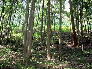
The ecology of Sydney, located in the state of New South Wales, Australia, is diverse for its size, where it would mainly feature biomes such as grassy woodlands or savannas and some sclerophyll forests, with a few pockets of mallee shrublands, subtropical and temperate rainforests (evergreen), heathlands, and wetlands. The combination of climate, topography, moisture, and soil influence the dispersion of these ecological communities across a height gradient from 0 to 200 metres. There are many hiking trails, paved and unpaved roads for exploring the many different biomes and ecosystems.

References

  1. 1 2 "Port Hacking (Bay)". Geographical Names Register (GNR) of NSW. Geographical Names Board of New South Wales . Retrieved 8 January 2013. OOjs UI icon edit-ltr-progressive.svg
  2. 1 2 "Hacking River". Geographical Names Register (GNR) of NSW. Geographical Names Board of New South Wales . Retrieved 29 December 2013. OOjs UI icon edit-ltr-progressive.svg
  3. 1 2 "Map of Hacking River, NSW". Bonzle Digital Atlas of Australia. Retrieved 29 December 2013.
  4. Heathcote, Angela (1 June 2017). "On this day: Pemulwuy is killed". Australian Geographic. Retrieved 7 May 2020.
  5. "Hacking River". NSW Water Quality and River Flow Objectives. Government of New South Wales. 1 May 2006. Retrieved 20 August 2011.
  6. 1 2 3 4 5 NSW National Parks, Wildlife Service (February 2000). "Royal National Park, Heathcote National Park and Garawarra State Recreation Area: Plan of Management" (PDF). Sydney: Government of New South Wales . Retrieved 20 August 2011.
  7. Floyd, A. G. (1990). Australian Rainforests in New South Wales. Vol. 2. p. 116. ISBN   0-949324-32-9.
  8. "Otford Eco".
  9. "Port Hacking Integrated Environmental Management Plan" (PDF). Sutherland Shire Council. 2008. p. 31. Archived from the original (PDF) on 28 March 2011. Retrieved 8 January 2012.
  10. Curby, Pauline (2002). Pictorial History Sutherland Shire. Kingsclear Books Pty Ltd. p. 36. ISBN   0-908272-79-0.
  11. Albani, A. D.; Cotis, George (2013). Port Hacking: Past and present of an estuarine environment.