| Wards River | |
|---|---|
| Etymology | In honour of William Ward, a founding director of AA Co [1] |
| Location | |
| Country | Australia |
| State | New South Wales |
| Region | NSW North Coast (IBRA), Mid North Coast, Upper Hunter |
| Local government area | Mid-Coast Council |
| Physical characteristics | |
| Source | Kyle Range, Great Dividing Range |
| • location | near Waukivory, Gloucester |
| • elevation | 399 m (1,309 ft) |
| Mouth | confluence with the Mammy Johnsons River |
• location | Johnsons Creek, near Stroud |
• elevation | 65 m (213 ft) |
| Length | 31 km (19 mi) |
| Basin features | |
| River system | Mid-Coast Council [2] |
| Tributaries | |
| • right | Spring Creek (New South Wales) |
| [3] | |
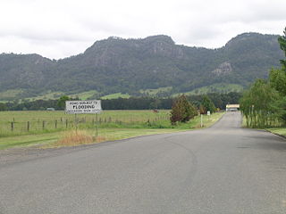
Wards River, a mostly perennial river of the Mid-Coast Council [2] system, is located in the Mid North Coast and Upper Hunter regions of New South Wales, Australia.
Wards River rises within Kyle Range of the Great Dividing Range, near Waukivory, south southeast of Gloucester, and flows generally west and south, joined by one minor tributary, before reaching its confluence with Mammy Johnsons River at the locale of Johnsons Creek, north of Stroud. The river descends 334 metres (1,096 ft) over its 31 kilometres (19 mi) course. [3]
First surveyed by European explorers during the 1820s, the river was named in honour of William Ward, a founding director of Australian Agricultural Company. [1]
The Bucketts Way is a 151-kilometre (94 mi) rural road that links Gloucester to Taree and Raymond Terrace, in New South Wales, Australia. It was named after the Bucketts Mountains, a prominent mountain range near Gloucester. Between 1928 and 1952 the Bucketts Way served as the alignment of the Pacific Highway between Raymond Terrace and Taree. The entire route is designated as Tourist Drive TD2.

Myall River, an open semi-mature brackish freshwater barrier estuary of the Mid-Coast Council system, is located in the Mid North Coast region of New South Wales, Australia.

Karuah River, an open semi-mature tide dominated drowned valley estuary is located in the Mid North Coast and Hunter regions of New South Wales, Australia.

Barnard River, a perennial river of the Manning River catchment, is located in the Northern Tablelands and Mid North Coast districts of New South Wales, Australia.
Coolongolook River, a watercourse of the Mid-Coast Council system, is located in the Mid North Coast district of New South Wales, Australia.

Cooplacurripa River, a perennial river of the Manning River catchment, is located in the Northern Tablelands and Mid North Coast districts of New South Wales, Australia.
Deepwater River, a mostly perennial stream of the Dumaresq-Macintyre catchment within the Murray–Darling basin, is located in the Northern Tablelands district of New South Wales, Australia.

Gloucester River, a perennial river and major tributary of the Manning River catchment, is located in the Mid North Coast hinterland New South Wales, Australia.
Kerripit River, a perennial river of the Manning River catchment, is located in the Upper Hunter district of New South Wales, Australia.
Mammy Johnsons River, a mostly perennial river of the Mid-Coast Council system, is located in the Mid North Coast and Upper Hunter regions of New South Wales, Australia.
Oban River, a watercourse that is part of the Clarence River catchment, is located in the New England and Northern Tablelands districts of New South Wales, Australia.

Telegherry River, a perennial river of the Mid-Coast Council system, is located in the Mid North Coast and Upper Hunter regions of New South Wales, Australia.
The Branch River, a watercourse of the Mid-Coast Council system, is located in the Mid North Coast and Upper Hunter regions of New South Wales, Australia.

Wallamba River, a watercourse of the Mid-Coast Council system, is located in the Mid North Coast district of New South Wales, Australia.
Wallingat River, a watercourse of the Mid-Coast Council system, is located in the Mid North Coast district of New South Wales, Australia.
Wang Wauk River, a perennial river of the Great Lakes system, is located in the Mid North Coast region of New South Wales, Australia.

Wollomombi River, a perennial stream of the Macleay River catchment, is located in the Northern Tablelands district of New South Wales, Australia.
The Wyong River is a perennial river that is located in the Central Coast region of New South Wales, Australia.

Wallis Lake, an open and trained wave dominated barrier estuary, is located within the Mid-Coast Council local government area in the Mid North Coast region of New South Wales, Australia. Wallis Lake is located adjacent to the towns of Forster and Tuncurry, and adjacent to the east coast, about 308 kilometres (191 mi) north of Sydney.
Smiths Lake, an intermittently closed youthful saline coastal lagoon, is located within the Mid-Coast Council local government area in the Mid North Coast region of New South Wales, Australia. Smiths Lake is located adjacent to the village of Smiths Lake, and adjacent to the east coast, about 274 kilometres (170 mi) north of Sydney.
River systems and rivers of Hunter-Central Rivers catchment, New South Wales, Australia | |
|---|---|
| Manning River | |
| Great Lakes | |
| Hunter Valley and Hunter River | |
Coordinates: 32°15′S151°57′E / 32.250°S 151.950°E
| | This Mid-Coast Council geography article is a stub. You can help Wikipedia by expanding it. |
| This New South Wales river or creek related article is a stub. You can help Wikipedia by expanding it. |