Cynon Valley is a former coal mining valley in Wales. It lies between Rhondda and the Merthyr Valley and takes its name from the River Cynon. Aberdare is located in the north of the valley and Mountain Ash in the south. From 1974 to 1996, Cynon Valley was a local government district.

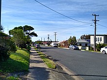
Hurlstone Park is a suburb in the Inner West of Sydney, New South Wales, Australia. Hurlstone Park is located nine kilometres south-west of the Sydney central business district and is mostly in the local government area of the City of Canterbury-Bankstown, and partly in the Inner West Council. The suburb is bounded by: the Cooks River to the south, Garnet Street to the east, New Canterbury Road to the north, Canterbury Road to the north-west, and Church Street to the west.

Mountain Ash is a town and former community in the Cynon Valley, within the County Borough of Rhondda Cynon Taf, Wales, with a population of 11,230 at the 2011 Census, estimated in 2019 at 11,339. It includes the districts and villages of Cefnpennar, Cwmpennar, Caegarw, Darranlas, Fernhill, Glenboi and Newtown, all within the historic county boundaries of Glamorgan. Aberdare lies about 4.5 miles (7.2 km) north-west, Cardiff 19 miles (31 km) south-east, and Penrhiwceiber a mile to the south-east. It divides into two communities : West covers the town centre and the districts of Miskin, Darranlas, Fernhill and Glenboi, and East the districts of Cefnpennar, Cwmpennar, Caegarw and Newtown.

New Forest West is a constituency represented in the House of Commons of the UK Parliament since 1997 by Desmond Swayne, a Conservative.

The Merthyr line is a commuter railway line in South Wales from central Cardiff to Merthyr Tydfil and Aberdare. The line is part of the Cardiff urban rail network, known as the Valley Lines.

The City of Penrith is a local government area in the state of New South Wales, Australia. The seat of the city is located in Penrith, located within Sydney about 50 kilometres (31 mi) west of Sydney central business district. It occupies part of the traditional lands of the Darug people. First incorporated as a municipality on 12 May 1871, on 1 January 1949, the municipalities of Penrith, St Marys and Castlereagh and part of the Nepean Shire amalgamated to form a new Municipality of Penrith. Penrith was declared a City on 21 October 1959, and expanded westwards to include Emu Plains and Emu Heights, formerly part of the City of Blue Mountains, on 25 October 1963. As of the 2021 census the City of Penrith had an estimated population of 217,664.
Mulgoa is a village, located in the local government area of the City of Penrith, in the region of western Sydney, in the state of New South Wales, Australia. Mulgoa is located approximately 66 kilometres (41 mi) west of the Sydney central business district.

Glenmore Park is a suburb of Sydney, in the state of New South Wales, Australia. Glenmore Park is located 54 kilometres (34 mi) west of the Sydney central business district, in the local government area of the City of Penrith and is part of the Greater Western Sydney region.

Llangain is a village and community in Carmarthenshire, in the south-west of Wales. Located to the west of the River Towy, and south of the town of Carmarthen, the community contains three standing stones, and two chambered tombs as well as the ruins of 15th century great house, Castell Moel. In 2001 the community's population was recorded at 574, decreasing slightly to 573 at the 2011 census.

The City of Lithgow is a local government area in the Central West region of New South Wales, Australia. The area is located adjacent to the Great Western Highway and the Main Western railway line.
Bowenfels is a small town on the western outskirts of Lithgow, New South Wales, Australia.

Blaenrhondda is a village in the county borough of Rhondda Cynon Taf, Wales, lying at the head the Rhondda Fawr valley. Blaenrhondda is a village and is part of the community of Treherbert.

Ceri Rhys Matthews is a Welsh traditional musician, record producer, and teacher.

Fernhill is a suburb of Queenstown in the South Island of New Zealand. It is located on the lower slopes of the Ben Lomond mountain, east of Sunshine Bay on the northern side of Lake Wakatipu.
Edward Cox was an English-born Australian politician.
Fernhill is a heritage-listed former chicken hatchery, plant nursery, guest house, farm, residence, stone mason's yard and piggery and now residence and horse stud located at 1041 Mulgoa Road, in the western Sydney suburb of Mulgoa in the City of Penrith local government area of New South Wales, Australia. Completed in c. 1840 as a residence for Captain William Cox and family, the house was completed in the Old Colonial Greek Revival style with its design attributed to either Mortimer Lewis, John Verge or Francis Clarke. The property is privately owned. It was added to the New South Wales State Heritage Register on 2 April 1999.

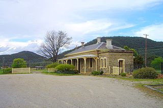
Fernhill is a heritage-listed former house and former inn located beside the Great Western Highway in Bowenfels, City of Lithgow, New South Wales, Australia. It was built from 1856 to 1859 by John Blackman. It is also known as Australia Arms Inn. The property is owned by National Trust of Australia (NSW). It was added to the New South Wales State Heritage Register on 2 April 1999. On 18 July 2019 it was sold as a residential property.
Christopher Kapessa was a Welsh boy who died at the age of 13 in the River Cynon on 1 July 2019. He was pushed from a height of 2.5 metres into the water and declared dead on the same day.
Sunshine Bay is an inlet of Lake Wakatipu and suburb of Queenstown in the South Island of New Zealand. It is located on the lower slopes of the Ben Lomond mountain, west of Fernhill, on the northern side of the lake.