Clifton, New South Wales

Last updated

Clifton
Wollongong,  New South Wales
Clifton, NSW (5).jpg
View of Clifton from the Lawrence Hargrave Drive c. 2018
Australia New South Wales location map blank.svg
Red pog.svg
Clifton
Coordinates 34°15′34″S150°58′09″E / 34.25944°S 150.96917°E / -34.25944; 150.96917 Coordinates: 34°15′34″S150°58′09″E / 34.25944°S 150.96917°E / -34.25944; 150.96917
Population28 (2016 census) [1]
Postcode(s) 2515
Elevation80 m (262 ft)
Location
LGA(s) City of Wollongong
State electorate(s) Heathcote
Federal division(s) Cunningham
Suburbs around Clifton:
Coalcliff
Clifton
Scarborough

Clifton is a village on the coast of New South Wales, Australia, between Sydney and Wollongong. Along with nearby Coalcliff, the village began life as a coal-mining centre. It is situated on a narrow area between the sea and the Illawarra escarpment. The electrified South Coast railway line passes through, but the station at Clifton was closed in 1915. [2] It reopened on 1934-07-04 and closed for the last time on 1983-11-27, [3] at the time of double tracking and electrification.

Contents

The Sea Cliff Bridge, opened in 2005, restored the connection between Clifton and Coalcliff, broken by frequent rock falls onto this section of the Lawrence Hargrave Drive. The bridge lies parallel to the former "coal cliffs" and offers scenic views of the cliffs, the sea, and surrounding coastline.

History

In 1797, survivors of the Sydney Cove discovered coal in the 'Coal Cliffs'. Clifton was created with the construction of the Coal Cliff Colliery in 1877. It was situated on the southern end of the Stanwell Park Estate owned by surveyor Sir Thomas Mitchell. A number of weatherboard cottages with galvanised iron roofs had been built. The mine officially opened in 1878. In 1880, the School of Arts was established. Thomas Hale, the first mine manager, constructed a 500-foot (150 m) jetty out to sea and a slide down the 120-foot (37 m) cliff. This took coal to Hilda and Herga, two steam colliers built in Glasgow. Hilda struck a reef near Port Hacking in 1893. In 1878 the mine employed 73 men. By 1884 there were 150 miners, and coal production was 51,500 tons annually. Most of the miners lived, with their families, in Clifton. There was a post/telegraph office, school, (opened 1879), and James Farraher's Clifton Inn and in 1884 the press reported near 1000 residents, a large proportion of which worked at the mines. In 1879 a mail service to Bulli was established.

The mine closed after storms destroyed the jetty and job losses crippled the village. In 1887 the railway line had reached Clifton from Wollongong. Before this time four-horse coaches would travel between Wollongong and Clifton, starting from Wollongong at 5 am. In 1884 an Anglican and a Roman Catholic Church were built. A public hall was built in 1885. In 1887 the railway between Wollongong and Clifton was opened. In 1890 the Coal Cliff Coal and Land Company Ltd took over the colliery. In 1893 the Clifton School was opened. In 1910 the miners at the Coal Cliff Colliery went on strike for ten months. Also in 1910 the school of arts building was built. The strikers supplied some of the required labour for this project. In 1919 additions were made to the Catholic Church and it was blessed in a ceremony on the first of March.

From May 8th to 10th, 1972, about sixty miners took over the mine at South Clifton in protest of its closure on May 5th, ensuring the mine was reopened for a further period; all workers were returned to the payroll and promised work at other mines after the closure. [4]

The Imperial Hotel in 2022 The Imperial, Clifton - 2022.jpg
The Imperial Hotel in 2022

The Imperial Hotel was established 1884 by Allan Broadhead as a miners Pub. [5] It closed in November 2002 after the collapse of Lawrence Hargrave Drive (now replaced by the Sea Cliff Bridge). It has now been purchased and restored by Shellharbour Workers Club. [6]

Related Research Articles

<span class="mw-page-title-main">Wollongong</span> City in New South Wales, Australia

Wollongong, colloquially referred to as The Gong, is a city located in the Illawarra region of New South Wales, Australia. The name is believed to originate from the Dharawal language, meaning either 'five islands/clouds', 'ground near water' or 'sound of the sea'. Wollongong lies on the narrow coastal strip between the Illawarra Escarpment and the Pacific Ocean, 85 kilometres south of central Sydney. Wollongong had an estimated urban population of 302,739 at June 2018, making it the third-largest city in New South Wales after Sydney and Newcastle and the tenth-largest city in Australia by population. The city's current Lord Mayor is Gordon Bradbery AM who was elected in 2021.

<span class="mw-page-title-main">Bulli, New South Wales</span> Suburb of Wollongong, New South Wales, Australia

Bulli is a northern suburb of Wollongong situated on the south coast of New South Wales, Australia.

<span class="mw-page-title-main">Illawarra</span> Region in New South Wales, Australia

The Illawarra is a coastal region in the Australian state of New South Wales, nestled between the mountains and the sea. It is situated immediately south of Sydney and north of the South Coast region. It encompasses the two cities of Wollongong, Shellharbour and the coastal town of Kiama. Wollongong is the largest city of the Illawarra with a population of 240,000, then Shellharbour with a population of 70,000 and Kiama with a population of 10,000. These three cities have their own suburbs. Wollongong stretches from Otford in the north to Windang in the south, with Maddens Plains and Cordeaux in the west.

<span class="mw-page-title-main">Mount Keira</span> Suburb of Wollongong, New South Wales, Australia

Mount Keira is a suburb and mountain in the Illawarra region of New South Wales, Australia.

<span class="mw-page-title-main">Stanwell Park, New South Wales</span> Suburb of Wollongong, New South Wales, Australia

Stanwell Park is a coastal village and northern suburb of Wollongong, New South Wales, Australia. It is the northernmost point of the Illawarra coastal strip and lies south of Sydney's Royal National Park. It is situated in a small valley between Bald Hill to the north, Stanwell Tops to the west and Mount Mitchell to the south. It has two lagoons from the village's two creeks, Stanwell and Hargrave Creeks and a beach running between headlands. Stanwell Park and the surrounding suburbs are colloquially referred to by its postcode 2508.

<span class="mw-page-title-main">Thirroul, New South Wales</span> Suburb of Wollongong, New South Wales, Australia

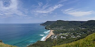
Thirroul is a northern seaside suburb of the city of Wollongong, Australia. Situated between Austinmer and Bulli, it is approximately 13 kilometres north of Wollongong, and 73 km south of Sydney. It lies between the Pacific Ocean and a section of the Illawarra escarpment known as Lady Fuller Park, adjacent to Bulli Pass Scenic Reserve.

<span class="mw-page-title-main">South Coast railway line, New South Wales</span> Railway line in New South Wales, Australia

The South Coast Railway is a commuter and goods railway line from Sydney to Wollongong and Bomaderry in New South Wales, Australia. Beginning at the Illawarra Junction, the line services the Illawarra and South Coast regions of New South Wales.

<span class="mw-page-title-main">South Coast Line</span> Rail service in New South Wales, Australia

The South Coast Line is an intercity rail service operated by NSW TrainLink that services the Illawarra region of New South Wales, Australia. The service runs from Central, and runs the entire length of the eponymous South Coast railway line to Bomaderry. The service also runs along the Eastern Suburbs railway line at peak hours and the Port Kembla railway line to Port Kembla. It is operated with NSW TrainLink H sets and Sydney Trains T sets, with Endeavour railcars operating the service on the non-electrified line between Kiama and Bomaderry.

<span class="mw-page-title-main">Unanderra railway station</span> Railway station in New South Wales, Australia

Unanderra railway station is located on the South Coast railway line in the Wollongong suburb of Unanderra, New South Wales, Australia.

<span class="mw-page-title-main">Sea Cliff Bridge</span> Bridge in New South Wales, Australia

The Sea Cliff Bridge, together with the adjoining Lawrence Hargrave Drive Bridge, are two road bridges that carry the scenic Lawrence Hargrave Drive across the rockface on the Illawarra escarpment, located in the northern Illawarra region of New South Wales, Australia. The balanced cantilever and incremental launching girder bridges link the coastal villages of Coalcliff and Clifton and carry two lanes of traffic, and a pedestrian walkway.

<span class="mw-page-title-main">Lawrence Hargrave Drive</span>

Lawrence Hargrave Drive, part of the Grand Pacific Drive, is a scenic coastal road and popular tourist drive connecting the northernmost suburbs of Wollongong, New South Wales, Australia, to Wollongong, in the south, and Sydney, in the north. The road was originally constructed in the 1870s as Lower Coast Road, until it was renamed in 1947 after Lawrence Hargrave, an Australian aviation pioneer and explorer who had a house at Stanwell Park and flew his devices from Bald Hill.

Agecroft Colliery was a coal mine on the Manchester Coalfield that opened in 1844 in the Agecroft district of Pendlebury, Lancashire, England. It exploited the coal seams of the Middle Coal Measures of the Lancashire Coalfield. The colliery had two spells of use; the first between 1844 and 1932, when the most accessible coal seams were exploited, and a second lease of life after extensive development in the late 1950s to access the deepest seams.

<span class="mw-page-title-main">Coalcliff, New South Wales</span> Suburb of Wollongong, New South Wales, Australia

Coalcliff is a town on the coast of New South Wales, Australia, between Sydney and Wollongong.

<span class="mw-page-title-main">Austinmer, New South Wales</span> Suburb of Wollongong, New South Wales, Australia

Austinmer is a northern village of Wollongong on the south coast of New South Wales, Australia. It sits in the northern Illawarra region, south of Stanwell Park and immediately north of Thirroul.

<span class="mw-page-title-main">Scarborough, New South Wales</span> Suburb of Wollongong, New South Wales, Australia

Scarborough is a small northern seaside suburb of Wollongong on the south coast of New South Wales, Australia. It sits in the northern Illawarra region on a narrow stretch between the Illawarra escarpment and sea cliffs.

<span class="mw-page-title-main">Bellambi, New South Wales</span> Suburb of Wollongong, New South Wales, Australia

Bellambi is a suburb of Wollongong in the Illawarra region of New South Wales, Australia. It has a railway station on the NSW TrainLink South Coast Line.

<span class="mw-page-title-main">Whitburn Colliery</span>

Whitburn Colliery was a coal mine located about three miles south of South Shields, North East England, located on the North Sea coast.

<span class="mw-page-title-main">Port Kembla harbour</span> Port in Australia

Port Kembla is a man-made cargo port or artificial harbour, with an outer harbour protected by breakwaters and an inner harbour constructed by dredging, located in the Illawarra region of New South Wales, Australia.

The Coastal coal-carrying trade of New South Wales involved the shipping of coal—mainly for local consumption but also for export or coal bunkering—by sea to Sydney from the northern and southern coal fields of New South Wales. It took place in the 19th and 20th centuries. It should not be confused with the export coal trade, which still exists today. There was also an interstate trade, carrying coal and coke to other Australian states that did not have local sources of black coal.

<span class="mw-page-title-main">Wollongong Harbour Precinct</span> Harbour precinct in Wollongong, New South Wales

Wollongong Harbour Precinct is a heritage-listed shipping harbour at Cliff Road and Endeavour Drive, in Wollongong, New South Wales, Australia. It was built in 1837. The historic precinct includes Belmore Basin, Government Dam, Government Basin, Stockade Point, Flagstaff Hill, Signal Hill, Brighton Beach, Boat Harbour and Fortress Hill. It was added to the New South Wales State Heritage Register on 5 May 2010.

References

  1. Australian Bureau of Statistics (27 June 2017). "Clifton (NSW)". 2016 Census QuickStats. Retrieved 16 July 2017. OOjs UI icon edit-ltr-progressive.svg
  2. "Clifton Railway Station". NSWrail.net. Retrieved 12 April 2008.
  3. "Stations demolished and not replaced". Railpage. Retrieved 14 June 2021.
  4. Ness, Immanuel (2014). New Forms of Worker Organization: The Syndicalist and Autonomist Restoration of Class Struggle Unionism. p. 200.
  5. "Former Imperial Hotel". G'day pubs. 8 August 2002. Retrieved 14 June 2021.
  6. "Clifton's Imperial Hotel is nearing completion after an extreme renovation from owners the Shellharbour Workers Club". Illawarra Mercury. 22 February 2021. Retrieved 14 June 2021.