Huntley, New South Wales (Wollongong)

Last updated

Huntley
Wollongong,  New South Wales
Australia New South Wales location map blank.svg
Red pog.svg
Huntley
Coordinates 34°29′50″S150°44′07″E / 34.49722°S 150.73528°E / -34.49722; 150.73528 Coordinates: 34°29′50″S150°44′07″E / 34.49722°S 150.73528°E / -34.49722; 150.73528
Population50 (2016 census) [1]
Postcode(s) 2530
LGA(s) City of Wollongong
State electorate(s) Shellharbour
Federal Division(s) Whitlam
Suburbs around Huntley:
Wongawilli Horsley
Avon Huntley Cleveland
Avondale

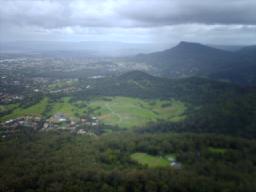
Huntley is a suburb of the City of Wollongong to the west of Dapto. At the 2016 census, it had a population of 50. [1]

City of Wollongong Local government area in New South Wales, Australia

The City of Wollongong is a local government area in the Illawarra region of New South Wales, Australia. The area is situated adjacent to the Tasman Sea, the Southern Freeway and the South Coast railway line.

Dapto, New South Wales Suburb of Wollongong, New South Wales, Australia

Dapto is a suburb of Wollongong in the Illawarra region of New South Wales, Australia, located on the western side of Lake Illawarra and covering an area 7.15 square kilometres in size. As at the 2016 census, the suburb had a population of 10,730.

The Geographical Names Board of New South Wales assigned the name of Huntley to the suburb on 5 August 2005. [2] It had previously been called West Dapto or considered to be part of Avondale. It was named after a coal mine located within its boundary. The mine's name "Huntley" came from Huntly, a coal mining town in the North Island of New Zealand, which originally had this spelling. The original owners of the Huntley colliery, Illawarra Coal, had associations with the New Zealand mine. [3]

The Geographical Names Board of New South Wales, a statutory authority of the Land and Property Information division, Department of Finance and Services in the Government of New South Wales, is the official body for naming and recording details of places and geographical names in the state of New South Wales, Australia.

Avondale, New South Wales Suburb of Wollongong, New South Wales, Australia

Avondale is a village in New South Wales. It is located just west of Lake Illawarra. At the 2016 census, it had a population of 1,653.

Huntly, New Zealand Minor urban area in Waikato, New Zealand

Huntly is a town in the Waikato district and region of the North Island of New Zealand. It is on State Highway 1, 95 kilometres (59 mi) south of Auckland and 32 kilometres (20 mi) north of Hamilton. It is situated on the North Island Main Trunk (NIMT) railway and straddles the Waikato River. Huntly is within the Waikato District which is in the northern part of the Waikato Region local government area.

Related Research Articles

Wollongong City in New South Wales, Australia

Wollongong, informally referred to as "The Gong", is a seaside city located in the Illawarra region of New South Wales, Australia. Wollongong lies on the narrow coastal strip between the Illawarra Escarpment and the Pacific Ocean, 68 kilometres (51 miles) south of central Sydney. Wollongong had an estimated urban population of 302,739 at June 2018, making it the third-largest city in New South Wales after Sydney and Newcastle, and the tenth-largest city in Australia. The city's current Lord Mayor is Gordon Bradbery AM who was elected in 2018.

Mount Kembla Suburb of Wollongong, New South Wales, Australia

Mount Kembla is a suburb and a mountain in the Illawarra region of New South Wales, Australia.

Illawarra escarpment

The Illawarra escarpment, or officially the Illawarra Range, is the fold-created cliffs and plateau-eroded outcrop mountain range west of the Illawarra coastal plain south of Sydney, in the state of New South Wales, Australia. The range encloses the Illawarra region which stretches from Stanwell Park in the north to Kiama, Gerringong and the Shoalhaven River in the south.

Marshall Mount, New South Wales Suburb of City of Wollongong, New South Wales, Australia

Marshall Mount is a suburb of Wollongong in New South Wales, Australia. It is located between the larger centres of Dapto and Albion Park.

The Cordeaux River, a perennial river of the Hawkesbury-Nepean catchment, is located in the Southern Highlands and Macarthur regions of New South Wales, Australia.

Wongawilli, New South Wales Suburb of Wollongong, New South Wales, Australia

Wongawilli is a southern suburb of Wollongong, Australia at the foot hills of the Illawarra escarpment. The word 'Wonga' is a native aboriginal word meaning native pigeon.

Russell Vale is a small suburb of Wollongong in the Illawarra region of New South Wales, Australia.

Cleveland, New South Wales Suburb of Wollongong, New South Wales, Australia

Cleveland is a suburb of the City of Wollongong to the west of Dapto. At the 2016 census, it had a population of 21.

Avon is as a suburb of the City of Wollongong and Wingecarribee Shire, both in New South Wales, Australia. It is: "a locality within Metropolitan Catchment Area on the western side of Illawarra Range about 4km west of Wongawilli and about 5km north west of Avondale". At the 2016 census, it had no population.

Mount Saint Thomas, New South Wales Suburb of Wollongong, New South Wales, Australia

Mount Saint Thomas is a suburb of Wollongong in New South Wales, lying east of Figtree and South west of Wollongong. At the 2016 census, it had a population of 1,468.

Haywards Bay, New South Wales Suburb of Wollongong, New South Wales, Australia

Haywards Bay is a suburb of the City of Wollongong to the south of Dapto. At the 2016 census, it had a population of 1,006.

Calderwood, New South Wales Suburb of City of Shellharbour, New South Wales, Australia

Calderwood is a suburb of Wollongong in the City of Shellharbour in New South Wales, Australia, lying to the west of Albion Park. At the 2016 census, it had a population of 173. It is currently largely rural, but is proposed for suburban development. It is estimated that the suburb will one day be home to a population of 12,000 people.

Brownsville, New South Wales Suburb of Wollongong, New South Wales, Australia

Brownsville is a suburb of the City of Wollongong. At the 2016 census, it had a population of 534.

Lake Heights, New South Wales Suburb of Wollongong, New South Wales, Australia

Lake Heights is a coastal suburb east of Berkeley and south of Cringila in the City of Wollongong. At the 2016 census, it had a population of 3,845.

Kembla Grange, New South Wales Suburb of Wollongong, New South Wales, Australia

Kembla Grange is a suburb west of Berkeley, in the City of Wollongong. At the 2016 census, it had a population of 252.

Gillieston Heights Suburb of Maitland, New South Wales, Australia

Gillieston Heights is a suburb of the City of Maitland local government area in the Hunter Region of New South Wales, Australia, approximately 5.1 km (3.2 mi) from the Maitland CBD. Prior to 1967, the village was named East Greta however this was changed to honour former Maitland mayor and member of the New South Wales Legislative Assembly John Gillies following a poll of residents. At the 2016 census, Gillieston Heights had a population of over 3,000.

Fernhill, New South Wales Suburb of Wollongong, New South Wales, Australia

Fernhill is a suburb west of Towradgi, in the City of Wollongong. At the 2016 census, it had a population of 1,023.

North Macquarie, New South Wales Suburb of Wollongong, New South Wales, Australia

North Macquarie is a suburb of Wollongong in the City of Shellharbour in New South Wales, Australia, 4 km west of Albion Park.

References

  1. 1 2 Australian Bureau of Statistics (27 June 2017). "Huntley (Wollongong - NSW)". 2016 Census QuickStats. Retrieved 17 July 2017. OOjs UI icon edit-ltr-progressive.svg
  2. "Huntley". Geographical Names Board of New South Wales . New South Wales Government . Retrieved 17 July 2017.
  3. "Suburb Profiles: Huntley". Wollongong City Libraries. Retrieved 17 July 2017.