
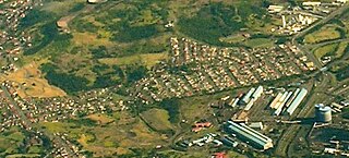
Port Kembla is a suburb of Wollongong 10 km south of the CBD and part of the Illawarra region of New South Wales. The suburb comprises a seaport, industrial complex, a small harbour foreshore nature reserve, and a small commercial sector. It is situated on the tip of Red Point: its first European sighting was by Captain James Cook in 1770. The name "Kembla" is an Aboriginal word meaning "plenty [of] wild fowl".

Woronora Heights is a suburb in southern Sydney, in the state of New South Wales, Australia. Woronora Heights is located 29 kilometres south of the Sydney central business district, in the local government area of the Sutherland Shire. Woronora is a separate suburb, to the north. Most streets in Woronora Heights are named after birds.

Wheeler Heights is a suburb of Northern Sydney, in the state of New South Wales, Australia. Wheeler Heights is located 22 kilometres north-east of the Sydney central business district, in the local government area of Northern Beaches Council and is part of the Northern Beaches region. Wheeler Heights was designated as a separate suburb in 1977 with a postcode of 2097 but was reassigned as a locality within Collaroy in 1984. In 2001, all localities were renamed Urban Places. In 2011, Wheeler Heights, along with Collaroy Plateau, was re-established as a suburb by the Geographical Names Board of NSW, after lobbying by the community, who had never ceased considering it to be a suburb since its loss of that title in 1984.

Chipping Norton is a suburb of Sydney, in the state of New South Wales, Australia. Chipping Norton is 27 kilometres south-west of the Sydney central business district, in the local government area of the City of Liverpool and is part of the South Western Sydney region.
Jerrabomberra is a suburb of Queanbeyan in south eastern New South Wales, Australia. Jerrabomberra consists of three sections, The Park, The Heights, and Lakeview. The Park and the Heights are divided by Edwin Land Parkway. At the 2021 census, it had 9,601 people, up from 9,508 in 2016, 9,420 in 2011, and 8,747 in 2006. Jerrabomberra is derived from the local Aboriginal place name meaning "boy frightened by storm".
Wollongong is an electoral district of the Legislative Assembly in the Australian state of New South Wales. It is represented by Paul Scully of the Labor Party. Since a redistribution in 2013, it has covered an area of 79.25 square kilometres and includes the localities of Berkeley, Coachwood Park, Coniston, Cordeaux Heights, Corrimal, Cringila, Fairy Meadow, Farmborough Chase, Farmborough Heights, Figtree, Gwynneville, Kembla Grange, Kembla Heights, Kemblawarra, Lake Heights, Lindsay Heights, Mangerton, Mount Kembla, Mount Saint Thomas, North Wollongong, Port Kembla, Primbee, Spring Hill, Towradgi, Unanderra, Warrawong, West Wollongong, Windang, Wollongong.
Cringila is a southern suburb of the city of Wollongong, New South Wales, Australia. The suburb is bounded by Berkeley, Unanderra, Lake Heights and Warrawong.

The City of Newcastle is a local government area in the Hunter region of New South Wales, Australia. The City of Newcastle incorporates much of the area of the Newcastle metropolitan area.
Barnsley is a township in New South Wales, Australia, 21 kilometres (13 mi) west of Newcastle's central business district. It is a suburb of the City of Lake Macquarie local government area.
Tingira Heights is a suburb of City of Lake Macquarie in New South Wales, Australia, 16 kilometres (10 mi) south-west of Newcastle's central business district on the eastern side of Lake Macquarie. It was developed in the 1960s.
Kilaben Bay is a suburb of the city of Lake Macquarie in the Hunter Region of New South Wales, Australia.
New Lambton Heights is a suburb of Newcastle, New South Wales, Australia, located 9 kilometres (6 mi) west of Newcastle's central business district. It is split between the City of Lake Macquarie and City of Newcastle local government areas.
Adamstown Heights is a southern suburb of Newcastle, New South Wales, Australia, located 8 kilometres (5 mi) west-southwest of Newcastle's central business district along the Pacific Highway. It is split between the City of Lake Macquarie and City of Newcastle local government areas. On 6 September 1991 Adamstown heights officially become a suburb of Newcastle.
Cardiff Heights is a suburb of the City of Lake Macquarie, Greater Newcastle, New South Wales, Australia. It is located 13 kilometres (8 mi) west of Newcastle's central business district, and is part of the City of Lake Macquarie West Ward.

Barrack Heights is a suburb of the City of Shellharbour in New South Wales, Australia in the local government area of the same name. Many institutions are located in Barrack Heights, including Shellharbour Public Hospital, Shellharbour Private Hospital, Warilla Bowling Club, Warilla Sports Club and Warilla High School.

Mount Warrigal is a large suburb of Shellharbour, New South Wales, Australia. The population, according to the 2021 Australian Census, was 4,880. The suburb is in the Shellharbour City LGA.
Berkeley is a suburb of Wollongong, New South Wales. The suburb is located in Wollongong's southern suburbs, on the northern shore of Lake Illawarra, and is one of the city's most populous suburbs. At the 2021 census, it had a population of 7,798.

Gillieston Heights is a suburb of the City of Maitland local government area in the Hunter Region of New South Wales, Australia, approximately 5.1 km (3.2 mi) from the Maitland CBD. Prior to 1967, the village was named East Greta however this was changed to honour former Maitland mayor and member of the New South Wales Legislative Assembly John Gillies following a poll of residents. At the 2021 census, Gillieston Heights had a population of 4,796.
